Difference between revisions of "2015-06-03 48 16"
imported>Micsnare ([live picture] [http://www.openstreetmap.org/?lat=48.15255631&lon=16.38851452&zoom=16&layers=B000FTF @48.1526,16.3885]) |
imported>FippeBot m (Location) |
||
| (9 intermediate revisions by 2 users not shown) | |||
| Line 15: | Line 15: | ||
}} | }} | ||
| − | + | ||
__NOTOC__ | __NOTOC__ | ||
== Location == | == Location == | ||
| − | + | ||
| + | |||
| + | [[Image:Hashhouse.jpg | thumb | left | This wonderful pretty house was next to our hashpoint...isn't it pretty?]] | ||
| + | |||
| + | The Hashpoint was located in directly in Vienna's 10th district. | ||
== Participants == | == Participants == | ||
| − | + | ||
| − | + | * [[User:Crankl|Crankl]] | |
| + | * [[User:B2c|B2c]] | ||
| + | * [[User:Micsnare|Micsnare]] | ||
== Plans == | == Plans == | ||
| − | + | ||
| + | It was tuesday late afternoon when Micsnare checked the Hash Coordinates for the next day. As soon as she realized it was a home match, as the hash lay directly in Vienna, she sent out an IM to her fellow hash buddies B2c and Crankl. The hash was located in a allotment garden residential estate, easily reachable by public transport. Finally a hashpoint in near their homebase again. | ||
| + | The plan was to meet up at 6pm near a subway & tram station, Reumannplatz. Well, that was the plan. | ||
== Expedition == | == Expedition == | ||
<!-- how it all turned out. your narrative goes here. --> | <!-- how it all turned out. your narrative goes here. --> | ||
| + | |||
| + | As said above the plan was to meet up at (around) 6pm at Reumannplatz. Unfortunately Micsnare had a crazy busy day and couldn't make to said place at 6pm, she was forced to reschedule it for half an hour later. So the new plan was 6.30pm. Since the guys were already on the way, B2c and Crankl decided to cherish the good weather and go for a beer instead. So, arriving a little later than planned, Micsnare finally met the guys and had a little drink herself. Micsnare had also planned on mapping the hash with open-street maps, but failed to find an appropriate Android app (can anyone recommend a good one?!). | ||
| + | |||
| + | After finishing the beers the 3 hashers made their way to the tram station. From there it was only 5 or 6 stops to the closest point, reachable by foot. The hash was surprisingly easy to find. The usual hash-dance wasn't required at this point, it was pretty straight forward. | ||
| + | We took our photos and screenshots and off we were, since it was a residential area we didn't wanna hang out there too long anyway... | ||
| + | |||
| + | On their way home they stopped at a pub, which had Guinness and Cider ready waiting for them.... the rest is history as we say. | ||
| + | |||
| + | == Original Geohash Droid Post == | ||
| + | |||
| + | *We're there, yay ;) -- [[User:Micsnare|Micsnare]] ([[User talk:Micsnare|talk]]) [http://www.openstreetmap.org/?lat=48.15299516&lon=16.38531846&zoom=16&layers=B000FTF @48.1530,16.3853] 13:40, 3 June 2015 (EDT) | ||
== Tracklog == | == Tracklog == | ||
| Line 34: | Line 53: | ||
== Photos == | == Photos == | ||
| − | < | + | <gallery caption="Photo Gallery" widths="320px" heights="213px" perrow="3"> |
| − | Image: | + | Image:IMG 20150603 190743.jpg | Crankl waiting for the tram. |
| − | + | Image:Route.jpg | The alley up to the hashpoint. | |
| − | + | Image:Hashhouse.jpg | This wonderful house marked the hashpoint. | |
| − | + | Image:IMG 20150603 193408.jpg | Crankl and Micsnare on the hashpoint. | |
| − | Image:2015-06- | + | Image:B2c sharp.jpg | B2c looking sharp as ever. |
| + | Image:B2c Crankl.jpg| Two happy hashers :) | ||
| + | Image:IMG 20150603 193508.jpg | Stupid grin(tm). | ||
| + | Image:Screenshot 2015-06-03-19-33-07.png | Proof. | ||
| + | Image:Screenshot 2015-06-03-19-33-49.png | More Proof. | ||
| + | Image:IMG 20150603 193829.jpg | The hashpoint from afar. | ||
</gallery> | </gallery> | ||
== Achievements == | == Achievements == | ||
{{#vardefine:ribbonwidth|800px}} | {{#vardefine:ribbonwidth|800px}} | ||
| − | |||
| + | * [[User:Micsnare|Micsnare]] | ||
| + | {{Public transport geohash|name=micsnare|latitude=48|longitude=16|date=2015-06-03}} | ||
| + | |||
| + | * [[User:B2c|B2c]] | ||
| + | {{Public transport geohash|name=B2c|latitude=48|longitude=16|date=2015-06-03}} | ||
| − | + | * [[User:Crankl|Crankl]] | |
| − | + | {{Public transport geohash|name=Crankl|latitude=48|longitude=16|date=2015-06-03}} | |
| − | |||
| − | |||
| − | |||
| − | |||
| − | |||
| − | |||
| − | |||
[[Category:Expeditions]] | [[Category:Expeditions]] | ||
| − | |||
[[Category:Expeditions with photos]] | [[Category:Expeditions with photos]] | ||
| − | |||
| − | |||
| − | |||
| − | |||
| − | |||
[[Category:Coordinates reached]] | [[Category:Coordinates reached]] | ||
| − | + | {{location|AT|W}} | |
| − | |||
| − | |||
| − | |||
| − | |||
| − | |||
| − | |||
| − | |||
| − | |||
| − | |||
| − | |||
| − | |||
| − | |||
| − | |||
| − | |||
| − | |||
| − | |||
| − | |||
Latest revision as of 03:53, 15 August 2019
| Wed 3 Jun 2015 in 48,16: 48.1525477, 16.3884927 geohashing.info google osm bing/os kml crox |
Location

The Hashpoint was located in directly in Vienna's 10th district.
Participants
Plans
It was tuesday late afternoon when Micsnare checked the Hash Coordinates for the next day. As soon as she realized it was a home match, as the hash lay directly in Vienna, she sent out an IM to her fellow hash buddies B2c and Crankl. The hash was located in a allotment garden residential estate, easily reachable by public transport. Finally a hashpoint in near their homebase again. The plan was to meet up at 6pm near a subway & tram station, Reumannplatz. Well, that was the plan.
Expedition
As said above the plan was to meet up at (around) 6pm at Reumannplatz. Unfortunately Micsnare had a crazy busy day and couldn't make to said place at 6pm, she was forced to reschedule it for half an hour later. So the new plan was 6.30pm. Since the guys were already on the way, B2c and Crankl decided to cherish the good weather and go for a beer instead. So, arriving a little later than planned, Micsnare finally met the guys and had a little drink herself. Micsnare had also planned on mapping the hash with open-street maps, but failed to find an appropriate Android app (can anyone recommend a good one?!).
After finishing the beers the 3 hashers made their way to the tram station. From there it was only 5 or 6 stops to the closest point, reachable by foot. The hash was surprisingly easy to find. The usual hash-dance wasn't required at this point, it was pretty straight forward. We took our photos and screenshots and off we were, since it was a residential area we didn't wanna hang out there too long anyway...
On their way home they stopped at a pub, which had Guinness and Cider ready waiting for them.... the rest is history as we say.
Original Geohash Droid Post
- We're there, yay ;) -- Micsnare (talk) @48.1530,16.3853 13:40, 3 June 2015 (EDT)
Tracklog
Photos
- Photo Gallery
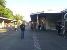
Crankl waiting for the tram.

The alley up to the hashpoint.
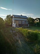
This wonderful house marked the hashpoint.
Crankl and Micsnare on the hashpoint.

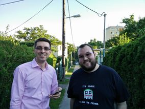
B2c looking sharp as ever.
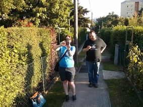
Two happy hashers :)
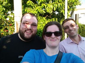
Stupid grin(tm).
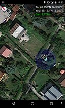
Proof.
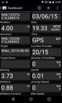
More Proof.
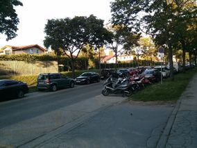
The hashpoint from afar.


Achievements
micsnare earned the Public transport geohash achievement
|
B2c earned the Public transport geohash achievement
|
Crankl earned the Public transport geohash achievement
|