Difference between revisions of "2015-06-18 49 8"
From Geohashing
imported>Tads (create) |
imported>Tads |
||
| Line 18: | Line 18: | ||
__NOTOC__ | __NOTOC__ | ||
== Location == | == Location == | ||
| − | + | The hashpoint was located in a wood near Grube Prinz von Hessen close to Darmstadt | |
== Participants == | == Participants == | ||
| − | + | [[User:Tads|Tads]] ([[User talk:Tads|talk]]) | |
| − | |||
| − | |||
| − | |||
| − | |||
== Expedition == | == Expedition == | ||
| − | + | Overall it has been a rainy day, but then it cleared up in the afternoon. So I went on my bike and did the short trip (~8km) to the hashpoint close to the [https://de.wikipedia.org/wiki/Grube_Prinz_von_Hessen "Grube Prinz von Hessen"]. I found the coordinates of the hashpoint in a wood, there was nothing spectacular around. After I marked the location with a large wooden X, I cycled to the Oberwaldhaus and the Oberfeld, took some photos and then continued home. | |
| − | |||
| − | |||
| − | |||
== Photos == | == Photos == | ||
| − | |||
| − | |||
| − | |||
<gallery perrow="5"> | <gallery perrow="5"> | ||
| + | Image:Tads_proof_2015-06-18_49_8.png | proof | ||
| + | Image:Tads_marker_2015-06-18_49_8.jpg | marker | ||
</gallery> | </gallery> | ||
| Line 49: | Line 41: | ||
[[Category:New report]] | [[Category:New report]] | ||
| − | |||
| − | |||
| − | |||
| − | |||
| − | |||
| − | |||
| − | |||
[[Category:Expeditions]] | [[Category:Expeditions]] | ||
| − | |||
[[Category:Expeditions with photos]] | [[Category:Expeditions with photos]] | ||
| − | |||
| − | |||
| − | |||
| − | |||
| − | |||
[[Category:Coordinates reached]] | [[Category:Coordinates reached]] | ||
| − | |||
| − | |||
| − | |||
| − | |||
| − | |||
| − | |||
| − | |||
| − | |||
| − | |||
| − | |||
| − | |||
| − | |||
| − | |||
| − | |||
| − | |||
| − | |||
| − | |||
| − | |||
Revision as of 09:45, 19 June 2015
| Thu 18 Jun 2015 in 49,8: 49.8955037, 8.7350365 geohashing.info google osm bing/os kml crox |
Location
The hashpoint was located in a wood near Grube Prinz von Hessen close to Darmstadt
Participants
Expedition
Overall it has been a rainy day, but then it cleared up in the afternoon. So I went on my bike and did the short trip (~8km) to the hashpoint close to the "Grube Prinz von Hessen". I found the coordinates of the hashpoint in a wood, there was nothing spectacular around. After I marked the location with a large wooden X, I cycled to the Oberwaldhaus and the Oberfeld, took some photos and then continued home.
Photos
proof
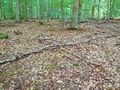
marker

