Difference between revisions of "2015-06-21 43 -86"
imported>Mcbaneg (→Location) |
imported>FippeBot m (Location) |
||
| (6 intermediate revisions by one other user not shown) | |||
| Line 24: | Line 24: | ||
<!-- who attended: If you link to your wiki user name in this section, your expedition will be picked up by the various statistics generated for geohashing. You may use three tildes ~ as a shortcut to automatically insert the user signature of the account you are editing with. | <!-- who attended: If you link to your wiki user name in this section, your expedition will be picked up by the various statistics generated for geohashing. You may use three tildes ~ as a shortcut to automatically insert the user signature of the account you are editing with. | ||
--> | --> | ||
| + | *[[User:Mcbaneg|Mcbaneg]] ([[User talk:Mcbaneg|talk]]) | ||
| + | *Rebekah | ||
| + | *Katja | ||
| + | *Susanne (driver, did not brave raptor-like vegetation) | ||
== Plans == | == Plans == | ||
| Line 33: | Line 37: | ||
*Arrived at briar patch. -- [[User:Mcbaneg|Mcbaneg]] ([[User talk:Mcbaneg|talk]]) [http://www.openstreetmap.org/?lat=43.52627943&lon=-86.48233936&zoom=16&layers=B000FTF @43.5263,-86.4823] 14:14, 21 June 2015 (EDT) | *Arrived at briar patch. -- [[User:Mcbaneg|Mcbaneg]] ([[User talk:Mcbaneg|talk]]) [http://www.openstreetmap.org/?lat=43.52627943&lon=-86.48233936&zoom=16&layers=B000FTF @43.5263,-86.4823] 14:14, 21 June 2015 (EDT) | ||
| − | + | ||
| − | + | It was Father's Day and we were deciding between a visit to the new Japanese garden at the sculpture park and a trip to the lakeshore to visit a state park we like and have dinner with some friends. As if the latter didn't already sound better, a hashpoint was just a few meters off the road on the way. Decision made. | |
| + | |||
| + | I thought the hashpoint might actually be on the roadside, and we might have a nice view over Lake Michigan. No luck on either front: it was a good six meters inside a mass of very thorny vegetation, within a forest that prevented any lake view. Nonetheless three of our party picked our way through the briars to reach the spot. | ||
== Photos == | == Photos == | ||
| Line 41: | Line 47: | ||
--> | --> | ||
<gallery perrow="5"> | <gallery perrow="5"> | ||
| + | Image:2015-06-21 43 -86_2.jpg | G, heading in. | ||
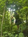
| + | Image:2015-06-21 43 -86_3.jpg | G, at hashpoint. | ||
| + | Image:2015-06-21 43 -86_4.jpg | K, heading in. | ||
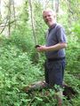
| + | Image:2015-06-21 43 -86_5.jpg | R, heading in. | ||
| + | Image:2015-06-21 43 -86_10.jpg | Local vegetation. | ||
| + | Image:2015-06-21 43 -86_proof.png | Proof. | ||
</gallery> | </gallery> | ||
| − | |||
| − | |||
| − | |||
| − | |||
| − | |||
| − | |||
| − | |||
| − | |||
| − | |||
| − | |||
| − | |||
| − | |||
| − | |||
| − | |||
| − | |||
| − | |||
[[Category:Expeditions]] | [[Category:Expeditions]] | ||
| − | |||
[[Category:Expeditions with photos]] | [[Category:Expeditions with photos]] | ||
| − | |||
| − | |||
| − | |||
| − | |||
| − | |||
[[Category:Coordinates reached]] | [[Category:Coordinates reached]] | ||
| − | + | {{location|US|MI|OA}} | |
| − | |||
| − | |||
| − | |||
| − | |||
| − | |||
| − | |||
| − | |||
| − | |||
| − | |||
| − | |||
| − | |||
| − | |||
| − | |||
| − | |||
| − | |||
| − | |||
| − | |||
Latest revision as of 01:06, 7 August 2019
| Sun 21 Jun 2015 in 43,-86: 43.5262709, -86.4823409 geohashing.info google osm bing/os kml crox |
Location
Just off route B15 ("Scenic Drive") west of Rothbury, MI, USA
Participants
Plans
Expedition
- Arrived at briar patch. -- Mcbaneg (talk) @43.5263,-86.4823 14:14, 21 June 2015 (EDT)
It was Father's Day and we were deciding between a visit to the new Japanese garden at the sculpture park and a trip to the lakeshore to visit a state park we like and have dinner with some friends. As if the latter didn't already sound better, a hashpoint was just a few meters off the road on the way. Decision made.
I thought the hashpoint might actually be on the roadside, and we might have a nice view over Lake Michigan. No luck on either front: it was a good six meters inside a mass of very thorny vegetation, within a forest that prevented any lake view. Nonetheless three of our party picked our way through the briars to reach the spot.
Photos
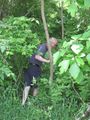
G, heading in.
G, at hashpoint.
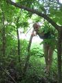
K, heading in.
R, heading in.
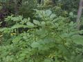
Local vegetation.
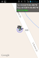
Proof.


