Difference between revisions of "2015-06-24 49 8"
imported>DODO (→Location) |
imported>FippeBot m (Location) |
||
| (10 intermediate revisions by one other user not shown) | |||
| Line 24: | Line 24: | ||
<!-- who attended: If you link to your wiki user name in this section, your expedition will be picked up by the various statistics generated for geohashing. You may use three tildes ~ as a shortcut to automatically insert the user signature of the account you are editing with. | <!-- who attended: If you link to your wiki user name in this section, your expedition will be picked up by the various statistics generated for geohashing. You may use three tildes ~ as a shortcut to automatically insert the user signature of the account you are editing with. | ||
--> | --> | ||
| + | [[User:DODO|DODO]] | ||
== Plans == | == Plans == | ||
<!-- what were the original plans --> | <!-- what were the original plans --> | ||
| + | Go there on my bull before work. | ||
== Expedition == | == Expedition == | ||
| − | + | Todays hashpoint was just 7 KM from home. Definitely to close not to go. As I didn't have a lot of time I took my bull in the early morning to go there before work. The ride was as expected. I've been on this road for several times and didn't expect any surprises. I had to leave the road some 100 m before the hashpoint. I rode along a forest path and after a while a fence started at my left side. Damn, that's the direction of the hash. I hope it'll stop soon enough. I rode on up to 60 m to the hash when it was in a right angle to the path and the fence was still on my left side. There was something like a gate so I could try to enter the fenced territory, but first I walked a bit further. Maybe the fence will end? And I didn't believe my eyes, just 30 m further the fence suddenly stopped, just to continue 5 m further, leaving a broad and overgrown way between the two fences. | |
| + | |||
| + | It was still quite early in the morning and the morning dew was hanging in the gras, just waiting for me to come along and take it with me when I walked through the knee high gras.The hashpoint came nearer and nearer and still there were fences on both sides of me but then, just when garmin was close to a right angle again, the fences stopped again and a small path crossed my way, which gave place to the hash today. Some hash dancing, some pictures and I quick walked back to my bull and rode home again to change my wet shoes before I continued my ride to work. | ||
| + | |||
| + | PS: When I came home from work I found 4 small black raptors that were biting me and I still feel some itching all over my body. So I have no photographical proof of it but I definitely fought some of them. | ||
== Tracklog == | == Tracklog == | ||
<!-- if your GPS device keeps a log, you may post a link here --> | <!-- if your GPS device keeps a log, you may post a link here --> | ||
| + | [https://www.komoot.de/tour/5517216 15 KM Bullriding] | ||
== Photos == | == Photos == | ||
| Line 38: | Line 45: | ||
Image:2012-##-## ## ## Alpha.jpg | Witty Comment | Image:2012-##-## ## ## Alpha.jpg | Witty Comment | ||
--> | --> | ||
| − | <gallery perrow=" | + | <gallery perrow="4"> |
| + | Image:2015-06-24_4_8-2.jpg|I parked the bull 54m from the hash.. | ||
| + | Image:2015-06-24_4_8-1.jpg|...on a path... | ||
| + | Image:2015-06-24_4_8-3.jpg|...next to this fence... | ||
| + | Image:2015-06-24_4_8-4.jpg|...that opened for this passthrough... | ||
| + | Image:2015-06-24_4_8-6.jpg|... which leads directly to another path... | ||
| + | Image:2015-06-24_4_8-5.jpg|... with the hash ... | ||
| + | Image:2015-06-24_4_8-8.jpg| ... where a hasher with very wet shoes... | ||
| + | Image:2015-06-24_4_8-7.jpg|... was happy because he found it | ||
</gallery> | </gallery> | ||
| − | == Achievements == | + | ==Achievements== |
| − | |||
| − | |||
| + | {{land geohash | ||
| + | | latitude = 49 | ||
| + | | longitude = 8 | ||
| + | | date = 2015-06-24 | ||
| + | | name = DODO | ||
| + | }} | ||
| − | + | {{Velociraptor geohash | |
| − | + | | latitude = 49 | |
| − | + | | longitude = 8 | |
| − | + | | date = 2015-06-24 | |
| − | + | | name = DODO | |
| − | + | }} | |
| − | |||
| − | |||
| − | |||
| − | |||
| − | |||
[[Category:Expeditions]] | [[Category:Expeditions]] | ||
| − | |||
[[Category:Expeditions with photos]] | [[Category:Expeditions with photos]] | ||
| − | |||
| − | |||
| − | |||
| − | |||
| − | |||
[[Category:Coordinates reached]] | [[Category:Coordinates reached]] | ||
| − | + | {{location|DE|RP|RP}} | |
| − | |||
| − | |||
| − | |||
| − | |||
| − | |||
| − | |||
| − | |||
| − | |||
| − | |||
| − | |||
| − | |||
| − | |||
| − | |||
| − | |||
| − | |||
| − | |||
| − | |||
Latest revision as of 04:08, 15 August 2019
| Wed 24 Jun 2015 in 49,8: 49.3491501, 8.3503810 geohashing.info google osm bing/os kml crox |
Location
On a forestial path between Speyer and Iggelheim.
Participants
Plans
Go there on my bull before work.
Expedition
Todays hashpoint was just 7 KM from home. Definitely to close not to go. As I didn't have a lot of time I took my bull in the early morning to go there before work. The ride was as expected. I've been on this road for several times and didn't expect any surprises. I had to leave the road some 100 m before the hashpoint. I rode along a forest path and after a while a fence started at my left side. Damn, that's the direction of the hash. I hope it'll stop soon enough. I rode on up to 60 m to the hash when it was in a right angle to the path and the fence was still on my left side. There was something like a gate so I could try to enter the fenced territory, but first I walked a bit further. Maybe the fence will end? And I didn't believe my eyes, just 30 m further the fence suddenly stopped, just to continue 5 m further, leaving a broad and overgrown way between the two fences.
It was still quite early in the morning and the morning dew was hanging in the gras, just waiting for me to come along and take it with me when I walked through the knee high gras.The hashpoint came nearer and nearer and still there were fences on both sides of me but then, just when garmin was close to a right angle again, the fences stopped again and a small path crossed my way, which gave place to the hash today. Some hash dancing, some pictures and I quick walked back to my bull and rode home again to change my wet shoes before I continued my ride to work.
PS: When I came home from work I found 4 small black raptors that were biting me and I still feel some itching all over my body. So I have no photographical proof of it but I definitely fought some of them.
Tracklog
Photos
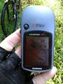
I parked the bull 54m from the hash..

...on a path...
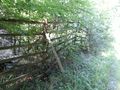
...next to this fence...
...that opened for this passthrough...
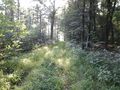
... which leads directly to another path...
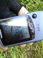
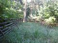
... with the hash ...
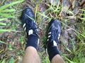
... where a hasher with very wet shoes...

... was happy because he found it


Achievements
DODO earned the Land geohash achievement
|
DODO earned the Velociraptor Geohash Achievement
|