Difference between revisions of "2015-07-11 39 -89"
imported>Mystrsyko |
imported>FippeBot m (Location) |
||
| (3 intermediate revisions by one other user not shown) | |||
| Line 1: | Line 1: | ||
| + | [[Image:2015-07-11 39 -89 panorama1.jpg|1100px]]<br> | ||
{{meetup graticule | {{meetup graticule | ||
| lat=39 | | lat=39 | ||
| Line 12: | Line 13: | ||
== Participants == | == Participants == | ||
*[[User:Mystrsyko|Mystrsyko]] | *[[User:Mystrsyko|Mystrsyko]] | ||
| + | *[[User:Dolphintreasure|Dolphintreasure]] | ||
== Plans == | == Plans == | ||
| Line 17: | Line 19: | ||
== Expedition == | == Expedition == | ||
| − | + | This hash looked like it would be withing pretty easy bike distance, so I decided that after I finished work at 5pm I would change clothes and bike out to the point. However, as things tend to go in life, that didn't work out as planned. I was stuck at work until 6:20pm, and just as I left for home my phone went off letting me know of a severe thunderstorm warning issued by the National Weather Service. As much as I wanted to get a [[Drowned Rat Geohash|Drowned Rat]] acheivement, a storm strong enough to draw a warning from the NWS is not something one should be outside in, so I decided to delay my departure until it had passed. | |
| + | |||
| + | This delay actually worked out in my favor. It gave [[User:Dolphintreasure|DolphinTreasure]] a chance to go, and we decided to drive instead of bike so we wouldn't have to worry about the storms in the area. Despite getting turned around once, we made our way to the area near the point and parked the car at a nearby gas station. The storm that had drawn the warning had since died, and we were in a nice little area surrounded by storms but without any overhead. Not having to fear lightning (yet), we made our way into the empty lot, which was quite muddy and gave Dolphintreasure trouble with her shoes. Finding the point was pretty easy given it was in an empty field, and I took some photos of the area before we headed back to the car. | ||
| − | |||
| − | |||
== Photos == | == Photos == | ||
| − | < | + | <gallery widths="250px" heights="190px" perrow="4"> |
| − | Image: | + | Image:2015-07-11 39 -89 storm.jpg|Many storms were in the area |
| − | -- | + | Image:2015-07-11 39 -89 dollar.jpg|Dolphintreasure found a dollar bill on the side of the road! |
| − | + | Image:2015-07-11 39 -89 grins.jpg|Successfull geohashers | |
| + | Image:2015-07-11 39 -89 proof.png|Proof | ||
</gallery> | </gallery> | ||
== Achievements == | == Achievements == | ||
{{#vardefine:ribbonwidth|800px}} | {{#vardefine:ribbonwidth|800px}} | ||
| − | + | {{land geohash | |
| − | + | | latitude = 39 | |
| − | + | | longitude = -89 | |
| − | + | | date = 2015-07-11 | |
| + | | name = Mystrsyko & Dolphintreasure | ||
| − | + | }} | |
| − | |||
| − | |||
| − | |||
| − | |||
| − | |||
[[Category:Expeditions]] | [[Category:Expeditions]] | ||
| − | |||
[[Category:Expeditions with photos]] | [[Category:Expeditions with photos]] | ||
| − | |||
| − | |||
| − | |||
| − | |||
| − | |||
[[Category:Coordinates reached]] | [[Category:Coordinates reached]] | ||
| − | + | {{location|US|IL|SM}} | |
| − | |||
| − | |||
| − | |||
| − | |||
| − | |||
| − | |||
| − | |||
| − | |||
| − | |||
| − | |||
| − | |||
| − | |||
| − | |||
| − | |||
| − | |||
| − | |||
| − | |||
Latest revision as of 04:19, 15 August 2019

| Sat 11 Jul 2015 in 39,-89: 39.7579840, -89.7341191 geohashing.info google osm bing/os kml crox |
Location
In what appears to be an empty lot at the corner of Archer Elevator Rd and Yucan Dr, in Springfield
Participants
Plans
Bike out there in the evening after I leave work, probably after 6pm
Expedition
This hash looked like it would be withing pretty easy bike distance, so I decided that after I finished work at 5pm I would change clothes and bike out to the point. However, as things tend to go in life, that didn't work out as planned. I was stuck at work until 6:20pm, and just as I left for home my phone went off letting me know of a severe thunderstorm warning issued by the National Weather Service. As much as I wanted to get a Drowned Rat acheivement, a storm strong enough to draw a warning from the NWS is not something one should be outside in, so I decided to delay my departure until it had passed.
This delay actually worked out in my favor. It gave DolphinTreasure a chance to go, and we decided to drive instead of bike so we wouldn't have to worry about the storms in the area. Despite getting turned around once, we made our way to the area near the point and parked the car at a nearby gas station. The storm that had drawn the warning had since died, and we were in a nice little area surrounded by storms but without any overhead. Not having to fear lightning (yet), we made our way into the empty lot, which was quite muddy and gave Dolphintreasure trouble with her shoes. Finding the point was pretty easy given it was in an empty field, and I took some photos of the area before we headed back to the car.
Photos
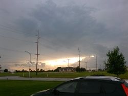
Many storms were in the area

Dolphintreasure found a dollar bill on the side of the road!

Successfull geohashers
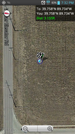
Proof


Achievements
Mystrsyko & Dolphintreasure earned the Land geohash achievement
|