Difference between revisions of "2015-07-12 48 11"
imported>Klaus |
imported>FippeBot m (Location) |
||
| (5 intermediate revisions by one other user not shown) | |||
| Line 1: | Line 1: | ||
| − | |||
| − | |||
| − | |||
| − | |||
| − | |||
| − | |||
| − | |||
| − | |||
| − | |||
| − | |||
{{meetup graticule | {{meetup graticule | ||
| lat=48 | | lat=48 | ||
| Line 14: | Line 4: | ||
| date=2015-07-12 | | date=2015-07-12 | ||
}} | }} | ||
| + | |||
| + | [[Image:{{{image|2015-07-12_48_11_geohash.jpg}}}|thumb|left]] | ||
__NOTOC__ | __NOTOC__ | ||
| Line 43: | Line 35: | ||
== Tracklog == | == Tracklog == | ||
| − | + | see below | |
== Photos == | == Photos == | ||
| − | |||
| − | |||
| − | |||
| − | |||
<gallery perrow="5"> | <gallery perrow="5"> | ||
| + | Image:2015-07-12_48_11_isar.jpg | View from the bridge on the Isar river | ||
| + | Image:2015-07-12_48_11_geohash.jpg | View from the geohash, unfortunately quite blurry | ||
| + | Image:2015-07-12_48_11_proof.jpg | Proof, unfortunately quite blurry, too (48.03254, 11.53631) | ||
| + | Image:2015-07-12_48_11_route.png | Tracklog | ||
</gallery> | </gallery> | ||
| Line 72: | Line 64: | ||
[[Category:Expeditions]] | [[Category:Expeditions]] | ||
| − | + | [[Category:Expeditions with photos]] | |
[[Category:Coordinates reached]] | [[Category:Coordinates reached]] | ||
| + | {{location|DE|BY|M}} | ||
Latest revision as of 04:20, 15 August 2019
| Sun 12 Jul 2015 in 48,11: 48.0325129, 11.5363002 geohashing.info google osm bing/os kml crox |

Location
In the forest next to Grünwald, München
Participants
Plans
I noticed that the hash already on Friday... was not sure, if I would have some time on Sunday evening to visit it, so I didn't announce it or plan anything.
Expedition
I had some time!
First of all, luckily Grünwald and thus the hash was still in the inner circle (Zone 4) of MVV public transit, so I didn't have to pay anything extra. Unfortunately, I'm staying in the very north of Munich and thus had to travel through the complete inner city twice (back and forth, linear distance according to my Garmin 20km) which is 1 hour each way.
So I left at around 18:30, took the S8 and S7, arrived in Höllriegelskreuth around 19:30 and walked to Grünwald. I had to cross the river Isar, and walked through the (exclusive) residential areas of Grünwald. Fun fact: Grünwald is the municipial with the highest average income in Germany (147% higher as the German average)!
The hash was easy to reach, except for the last 200m which were thick forest. The geohash was very near to some houses, but still in the (public ?) forest and I think nobody noticed me.
I didn't stay for long, and walked back to "Derbolfinger Platz", where I took the bus 25 at 20:52, the U1 and the S8 back to my hotel.
Tracklog
see below
Photos
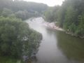
View from the bridge on the Isar river

View from the geohash, unfortunately quite blurry

Proof, unfortunately quite blurry, too (48.03254, 11.53631)
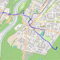
Tracklog


Achievements
Klaus earned the Land geohash achievement
|
Klaus earned the Public transport geohash achievement
|