Difference between revisions of "2015-07-15 49 8"
From Geohashing
imported>Tads (new page from template) |
imported>Tads |
||
| Line 19: | Line 19: | ||
== Location == | == Location == | ||
| − | + | The hashpoint was located on a field close to Griesheim. | |
== Participants == | == Participants == | ||
| − | + | [[User:Tads|Tads]] ([[User talk:Tads|talk]]) | |
| − | |||
== Plans == | == Plans == | ||
<!-- what were the original plans --> | <!-- what were the original plans --> | ||
| − | + | ToDo | |
== Expedition == | == Expedition == | ||
<!-- how it all turned out. your narrative goes here. --> | <!-- how it all turned out. your narrative goes here. --> | ||
| − | + | ToDo | |
| − | |||
| − | |||
== Photos == | == Photos == | ||
| Line 39: | Line 36: | ||
--> | --> | ||
<gallery perrow="5"> | <gallery perrow="5"> | ||
| + | Image:Tads_proof_2015-07-15_49_8.png | GPS Proof | ||
| + | Image:Tads_marker_2015-07-15_49_8.jpg | Marker xkcd | ||
| + | Image:Tads_marker2_2015-07-15_49_8.jpg | Marker x | ||
| + | Image:Tads_east_2015-07-15_49_8.jpg | View to the east | ||
| + | Image:Tads_north_2015-07-15_49_8.jpg | View to the north | ||
| + | Image:Tads_south_2015-07-15_49_8.jpg | View to the south | ||
| + | Image:Tads_west_2015-07-15_49_8.jpg | View to the west | ||
</gallery> | </gallery> | ||
| Line 45: | Line 49: | ||
<!-- Add any achievement ribbons you earned below, or remove this section --> | <!-- Add any achievement ribbons you earned below, or remove this section --> | ||
| − | |||
| − | |||
| − | |||
| − | |||
| − | |||
| − | |||
| − | |||
| − | |||
| − | + | [[Category:New report]] | |
| + | |||
[[Category:Expeditions]] | [[Category:Expeditions]] | ||
| − | |||
[[Category:Expeditions with photos]] | [[Category:Expeditions with photos]] | ||
| − | |||
| − | |||
| − | |||
| − | |||
| − | |||
[[Category:Coordinates reached]] | [[Category:Coordinates reached]] | ||
| − | |||
| − | |||
| − | |||
| − | |||
| − | |||
| − | |||
| − | |||
| − | |||
| − | |||
| − | |||
| − | |||
| − | |||
| − | |||
| − | |||
| − | |||
| − | |||
| − | |||
| − | |||
Revision as of 21:20, 15 July 2015
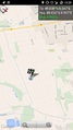
| Wed 15 Jul 2015 in 49,8: 49.8377639, 8.5473690 geohashing.info google osm bing/os kml crox |
Location
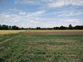
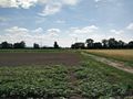
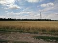
The hashpoint was located on a field close to Griesheim.
Participants
Plans
ToDo
Expedition
ToDo
Photos
GPS Proof
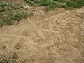
Marker xkcd
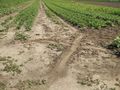
Marker x
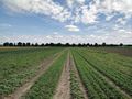
View to the east
View to the north
View to the south
View to the west


