Difference between revisions of "2015-07-17 49 11"
imported>Schnatterfleck (Enough little patio greenery for the better part of southern Germany [http://www.openstreetmap.org/?lat=49.50320000&lon=11.05080000&zoom=16&layers=B000FTF @49.5032,11.0508]) |
imported>FippeBot m (Location) |
||
| (9 intermediate revisions by 2 users not shown) | |||
| Line 20: | Line 20: | ||
== Location == | == Location == | ||
<!-- where you've surveyed the hash to be --> | <!-- where you've surveyed the hash to be --> | ||
| + | The watering pipeline in a field of celery near Kraftshof. | ||
== Participants == | == Participants == | ||
<!-- who attended: If you link to your wiki user name in this section, your expedition will be picked up by the various statistics generated for geohashing. You may use three tildes ~ as a shortcut to automatically insert the user signature of the account you are editing with. | <!-- who attended: If you link to your wiki user name in this section, your expedition will be picked up by the various statistics generated for geohashing. You may use three tildes ~ as a shortcut to automatically insert the user signature of the account you are editing with. | ||
--> | --> | ||
| + | [[User:Schnatterfleck|Schnatterfleck]] ([[User talk:Schnatterfleck|talk]]) | ||
== Plans == | == Plans == | ||
| Line 30: | Line 32: | ||
== Expedition == | == Expedition == | ||
<!-- how it all turned out. your narrative goes here. --> | <!-- how it all turned out. your narrative goes here. --> | ||
| + | Friday and some overtime to spend... And a hashpoint in reach! :-) | ||
| + | So I took a small detour with my bike through the Knoblauchsland ("garlic land" - ridiculous but accurate 500 year old name). | ||
| + | First I went through Nurembergs northern city and drove along the airport runway. | ||
| + | Then there were just plants. And lettuce. And vegetables. Some flowers. More plants. Going on for kilometres without and. A very special landscape. | ||
| + | Oh, and there are the various watering devices. It was 35°C and the sun was burning. But unfortunately the sprinkler right at the hashpoint was turned off. Damn. Would have been perfect. | ||
| + | Nonetheless - a very nice and refreshing (I got my dosage of sprinkler water on the way back :-) ) little adventure. | ||
== Tracklog == | == Tracklog == | ||
| Line 43: | Line 51: | ||
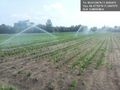
Image:2015-07-17_49_11_Schnatterfleck_1437135797174.jpg | Enough little patio greenery for the better part of southern Germany [http://www.openstreetmap.org/?lat=49.50320000&lon=11.05080000&zoom=16&layers=B000FTF @49.5032,11.0508] | Image:2015-07-17_49_11_Schnatterfleck_1437135797174.jpg | Enough little patio greenery for the better part of southern Germany [http://www.openstreetmap.org/?lat=49.50320000&lon=11.05080000&zoom=16&layers=B000FTF @49.5032,11.0508] | ||
| + | |||
| + | Image:2015-07-17_49_11_Schnatterfleck_-1.jpg | Another watering device. In the background you can make out the tower of Nuremberg's airport. [http://www.openstreetmap.org/?lat=49.50320000&lon=11.05060000&zoom=16&layers=B000FTF @49.5032,11.0506] | ||
| + | |||
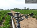
| + | Image:2015-07-17_49_11_Schnatterfleck_1437136367233.jpg | This watering device is located right at the hashpoint. [http://www.openstreetmap.org/?lat=49.51250000&lon=11.04330000&zoom=16&layers=B000FTF @49.5125,11.0433] | ||
| + | |||
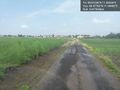
| + | Image:2015-07-17_49_11_Schnatterfleck_1437136402617.jpg | Interesting construction... [http://www.openstreetmap.org/?lat=49.51250000&lon=11.04330000&zoom=16&layers=B000FTF @49.5125,11.0433] | ||
| + | |||
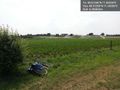
| + | Image:2015-07-17_49_11_Schnatterfleck_1437136470356.jpg | Bike near hashpoint. Artificial rain in the background. [http://www.openstreetmap.org/?lat=49.51250000&lon=11.04330000&zoom=16&layers=B000FTF @49.5125,11.0433] | ||
| + | |||
| + | Image:2015-07-17_49_11_Schnatterfleck_1437138626301.jpg | Finally getting really wet :-) [http://www.openstreetmap.org/?lat=49.47750000&lon=11.04470000&zoom=16&layers=B000FTF @49.4775,11.0447] | ||
| + | |||
| + | Image:2015-07-17_49_11_Schnatterfleck_1437138649277.jpg | Small rainbow (lower left) and asparagus field (also left) [http://www.openstreetmap.org/?lat=49.47760000&lon=11.04460000&zoom=16&layers=B000FTF @49.4776,11.0446] | ||
</gallery> | </gallery> | ||
| Line 51: | Line 71: | ||
<!-- =============== USEFUL CATEGORIES FOLLOW ================ | <!-- =============== USEFUL CATEGORIES FOLLOW ================ | ||
Delete the next line ONLY if you have chosen the appropriate categories below. If you are unsure, don't worry. People will read your report and help you with the classification. --> | Delete the next line ONLY if you have chosen the appropriate categories below. If you are unsure, don't worry. People will read your report and help you with the classification. --> | ||
| − | |||
<!-- Potential categories. Please include all the ones appropriate to your expedition --> | <!-- Potential categories. Please include all the ones appropriate to your expedition --> | ||
| Line 60: | Line 79: | ||
<!-- If all those plans are never acted upon, change [[Category:Expedition planning]] to [[Category:Not reached - Did not attempt]]. --> | <!-- If all those plans are never acted upon, change [[Category:Expedition planning]] to [[Category:Not reached - Did not attempt]]. --> | ||
| − | |||
[[Category:Expeditions]] | [[Category:Expeditions]] | ||
| − | |||
[[Category:Expeditions with photos]] | [[Category:Expeditions with photos]] | ||
| − | |||
| − | |||
| − | |||
| − | |||
| − | |||
[[Category:Coordinates reached]] | [[Category:Coordinates reached]] | ||
| − | + | {{location|DE|BY|N}} | |
| − | |||
| − | |||
| − | |||
| − | |||
| − | |||
| − | |||
| − | |||
| − | |||
| − | |||
| − | |||
| − | |||
| − | |||
| − | |||
| − | |||
| − | |||
| − | |||
| − | |||
Latest revision as of 04:23, 15 August 2019
| Fri 17 Jul 2015 in 49,11: 49.5124496, 11.0433368 geohashing.info google osm bing/os kml crox |
Location
The watering pipeline in a field of celery near Kraftshof.
Participants
Plans
Expedition
Friday and some overtime to spend... And a hashpoint in reach! :-) So I took a small detour with my bike through the Knoblauchsland ("garlic land" - ridiculous but accurate 500 year old name). First I went through Nurembergs northern city and drove along the airport runway. Then there were just plants. And lettuce. And vegetables. Some flowers. More plants. Going on for kilometres without and. A very special landscape. Oh, and there are the various watering devices. It was 35°C and the sun was burning. But unfortunately the sprinkler right at the hashpoint was turned off. Damn. Would have been perfect. Nonetheless - a very nice and refreshing (I got my dosage of sprinkler water on the way back :-) ) little adventure.
Tracklog
Photos
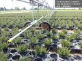
Massively parallel automated plant pot watering @49.5014,11.0523
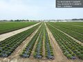
Enough little patio greenery for the better part of southern Germany @49.5032,11.0508
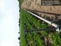
Another watering device. In the background you can make out the tower of Nuremberg's airport. @49.5032,11.0506
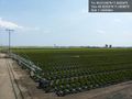
This watering device is located right at the hashpoint. @49.5125,11.0433
Interesting construction... @49.5125,11.0433
Bike near hashpoint. Artificial rain in the background. @49.5125,11.0433
Finally getting really wet :-) @49.4775,11.0447
Small rainbow (lower left) and asparagus field (also left) @49.4776,11.0446


