Difference between revisions of "2015-07-19 47 11"
imported>TheOneRing (Created page with "{{meetup graticule | lat=47 | lon=11 | date=2015-07-19 }} == Location == The geohash is in the city of Mittenwald. == Who Went == *TheOneRing - by public...") |
imported>FippeBot m (Location) |
||
| (2 intermediate revisions by one other user not shown) | |||
| Line 11: | Line 11: | ||
*[[User:TheOneRing|TheOneRing]] - by public transport. | *[[User:TheOneRing|TheOneRing]] - by public transport. | ||
| − | == The | + | == The Expedition == |
=== TheOneRing === | === TheOneRing === | ||
| − | From home, Mittenwald | + | From home, Mittenwald was easy to reach by train, so I took a chance. Mittenwald is close to the German-Austrian border and I passed it when I was geohashing in Innsbruck [[2015-01-18 47 11 | earlier this year]]. |
| + | |||
| + | Checking the time table of DB, I recognised that between two trains I could take were two hours delay, so I took the earlier one. Good choice, more about that later. | ||
| + | |||
| + | From the train station the geohash was about 300m away. Half past eleven, mission accomplished. And now? Well, I planned to walk through Mittenwald and maybe to find a restaurant or a cafe, but I still was indecisive. Already from the geohash, I saw the valley station of the Karwendelbahn, a funicular, and decided to take a closer look. | ||
| + | |||
| + | And here started part two of the tour, beginning with a very good decision: tickets weren't that expensive, so I went up. On top, there were signs to a point for panoramic views; my first goal. After walking back, I was again indecisive what to do next. There was a loop round, and well why not. | ||
| + | |||
| + | The different in Altitude were just about 100m, but the scenic view...indescribable. Photographs can only give a rough impression. Something I didn't know at the beginning: I was crossing the German-Austrian border, because a very small part of the trail is on Austrian territory. | ||
| + | |||
| + | After one hour or so, I completed the loop. Maybe you can be faster, but then you miss most of the impressive view. Afterwards, I took the next funicular to the valley station and walked back to the train station. | ||
| + | |||
| + | And exactly when I arrived at the train station, it started to rain. In the end, I was lucky to have taken the earlier train, because this way I completed the geohash and the framework programme. | ||
| + | |||
| + | Wonderful tour, really really great. | ||
| + | |||
| + | == Photos == | ||
| + | <gallery perrow="4"> | ||
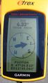
| + | Image:20150719_47_11GPS.jpg|Coordinates reached... | ||
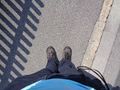
| + | Image:20150719_47_11Geohash.jpg|...here | ||
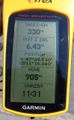
| + | Image:20150719_47_11Info.jpg|Some more information | ||
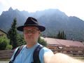
| + | Image:20150719_47_11Me.jpg|The hasher, the Karwendel in the background | ||
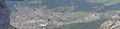
| + | Image:20150719_47_11Surrounding1.jpg|View from the geohash | ||
| + | Image:20150719_47_11Surrounding2.jpg|The river Isar near the geohash | ||
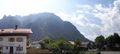
| + | Image:20150719_47_11Mittenwald.jpg|The city of Mittenwald, the arrow marks the geohash | ||
| + | Image:20150719_47_11Karwendel.jpg|Panoramic view over some Karwendel peaks | ||
| + | </gallery> | ||
| + | |||
| + | == Achievements == | ||
| + | {{land geohash | latitude = 47 | longitude = 11 | date = 2015-07-19 | name = TheOneRing}} | ||
| + | {{Public transport geohash | latitude = 47 | longitude = 11 | date = 2015-07-19 | name = TheOneRing}} | ||
| + | |||
| + | [[Category:Expeditions]] | ||
| + | [[Category:Expeditions with photos]] | ||
| + | [[Category:Coordinates reached]] | ||
| + | {{location|DE|BY|GAP}} | ||
Latest revision as of 01:09, 7 August 2019
| Sun 19 Jul 2015 in 47,11: 47.4417786, 11.2674051 geohashing.info google osm bing/os kml crox |
Location
The geohash is in the city of Mittenwald.
Who Went
- TheOneRing - by public transport.
The Expedition
TheOneRing
From home, Mittenwald was easy to reach by train, so I took a chance. Mittenwald is close to the German-Austrian border and I passed it when I was geohashing in Innsbruck earlier this year.
Checking the time table of DB, I recognised that between two trains I could take were two hours delay, so I took the earlier one. Good choice, more about that later.
From the train station the geohash was about 300m away. Half past eleven, mission accomplished. And now? Well, I planned to walk through Mittenwald and maybe to find a restaurant or a cafe, but I still was indecisive. Already from the geohash, I saw the valley station of the Karwendelbahn, a funicular, and decided to take a closer look.
And here started part two of the tour, beginning with a very good decision: tickets weren't that expensive, so I went up. On top, there were signs to a point for panoramic views; my first goal. After walking back, I was again indecisive what to do next. There was a loop round, and well why not.
The different in Altitude were just about 100m, but the scenic view...indescribable. Photographs can only give a rough impression. Something I didn't know at the beginning: I was crossing the German-Austrian border, because a very small part of the trail is on Austrian territory.
After one hour or so, I completed the loop. Maybe you can be faster, but then you miss most of the impressive view. Afterwards, I took the next funicular to the valley station and walked back to the train station.
And exactly when I arrived at the train station, it started to rain. In the end, I was lucky to have taken the earlier train, because this way I completed the geohash and the framework programme.
Wonderful tour, really really great.
Photos
Coordinates reached...
...here
Some more information
The hasher, the Karwendel in the background
View from the geohash
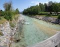
The river Isar near the geohash
The city of Mittenwald, the arrow marks the geohash
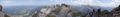
Panoramic view over some Karwendel peaks


Achievements
TheOneRing earned the Land geohash achievement
|
TheOneRing earned the Public transport geohash achievement
|