Difference between revisions of "2015-07-22 51 9"
imported>GeorgDerReisende (new report) |
imported>GeorgDerReisende (expedition report for Hofgeismar-Hümme) |
||
| Line 1: | Line 1: | ||
| − | |||
| − | |||
| − | |||
| − | |||
| − | |||
| − | |||
| − | |||
| − | |||
| − | |||
| − | |||
{{meetup graticule | {{meetup graticule | ||
| lat=51 | | lat=51 | ||
| Line 19: | Line 9: | ||
== Location == | == Location == | ||
| − | + | ||
| + | The hash lay on a field way beside the village Hümme. | ||
== Participants == | == Participants == | ||
| − | + | ||
| − | + | [[User:GeorgDerReisende|GeorgDerReisende]] | |
== Plans == | == Plans == | ||
| − | + | ||
| + | Hitchhiking. | ||
== Expedition == | == Expedition == | ||
| − | |||
| − | + | I left home at 11:15 and started to hitchhike at 12:20. The fourth car stopped and I arrived at Hofgeismar at 12:35. Then I walked to my usual spot to hitchhike further north and there I waited one hour. I started to walk along the national road, tried to hitchhike at another place, but nobody stopped and I had to walk to the village Schöneberg, where I got at least a lift to Hümme. At Hümme I arrived at 15:00. I walked to the hash and found it in the middle of the field way. I walked there and looked to the GPS and read seven, five, three, one meter. Zero. There was no need for a dance. I looked around, then I walked to the village, made a break, walked to the national road and started to hitchhike. I started to hitchhike at 16:05. The tenth car stopped and I got a direct lift to Kassel, where I arrived at 16:43, at home at 17:30. | |
| − | |||
== Photos == | == Photos == | ||
| − | |||
| − | |||
| − | |||
<gallery perrow="5"> | <gallery perrow="5"> | ||
| + | Image:2015-07-22 51 9 GeorgDerReisende 9664.jpg | the way to hash | ||
| + | Image:2015-07-22 51 9 GeorgDerReisende 9666.jpg | arrived | ||
| + | Image:2015-07-22 51 9 GeorgDerReisende 9714.jpg | proof of no dance | ||
| + | Image:2015-07-22 51 9 GeorgDerReisende 9668.jpg | the north | ||
| + | Image:2015-07-22 51 9 GeorgDerReisende 9669.jpg | the south | ||
| + | Image:2015-07-22 51 9 GeorgDerReisende 9670.jpg | the east | ||
| + | Image:2015-07-22 51 9 GeorgDerReisende 9671.jpg | the west | ||
| + | Image:2015-07-22 51 9 GeorgDerReisende 9672.jpg | the geohasher | ||
| + | Image:2015-07-22 51 9 GeorgDerReisende 9673.jpg | behind the trees of the west: the rivulet Esse | ||
| + | Image:2015-07-22 51 9 GeorgDerReisende 9676.jpg | behind the trees of the east: the national road | ||
| + | Image:2015-07-22 51 9 GeorgDerReisende 9689.jpg | the main street of Hümme | ||
</gallery> | </gallery> | ||
| Line 45: | Line 43: | ||
<!-- Add any achievement ribbons you earned below, or remove this section --> | <!-- Add any achievement ribbons you earned below, or remove this section --> | ||
| − | + | {{Thumbs Up | latitude = 51 | longitude = 9 | date = 2015-07-22 | name = GeorgDerReisende }} | |
| − | |||
| − | |||
| − | + | [[Category:Expeditions]] | |
| − | |||
| − | [[Category: | ||
| − | |||
| − | + | [[Category:Expeditions with photos]] | |
| − | |||
| − | |||
| − | |||
| − | |||
| − | |||
| − | |||
| − | |||
| − | |||
| − | |||
[[Category:Coordinates reached]] | [[Category:Coordinates reached]] | ||
| − | |||
| − | |||
| − | |||
| − | |||
| − | |||
| − | |||
| − | |||
| − | |||
| − | |||
| − | |||
| − | |||
| − | |||
| − | |||
| − | |||
| − | |||
| − | |||
| − | |||
| − | |||
Revision as of 16:26, 22 July 2015
| Wed 22 Jul 2015 in 51,9: 51.5441048, 9.4118321 geohashing.info google osm bing/os kml crox |
Location
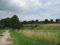
The hash lay on a field way beside the village Hümme.
Participants
Plans
Hitchhiking.
Expedition
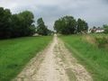
I left home at 11:15 and started to hitchhike at 12:20. The fourth car stopped and I arrived at Hofgeismar at 12:35. Then I walked to my usual spot to hitchhike further north and there I waited one hour. I started to walk along the national road, tried to hitchhike at another place, but nobody stopped and I had to walk to the village Schöneberg, where I got at least a lift to Hümme. At Hümme I arrived at 15:00. I walked to the hash and found it in the middle of the field way. I walked there and looked to the GPS and read seven, five, three, one meter. Zero. There was no need for a dance. I looked around, then I walked to the village, made a break, walked to the national road and started to hitchhike. I started to hitchhike at 16:05. The tenth car stopped and I got a direct lift to Kassel, where I arrived at 16:43, at home at 17:30.
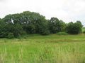
Photos
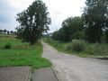
the way to hash

arrived
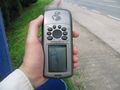
proof of no dance
the north
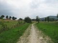
the south
the east
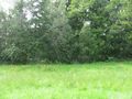
the west
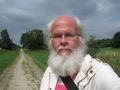
the geohasher
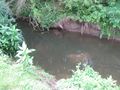
behind the trees of the west: the rivulet Esse
behind the trees of the east: the national road
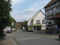
the main street of Hümme


Achievements
GeorgDerReisende earned the Thumbs Up Geohash Achievement
|