Difference between revisions of "2015-08-09 49 8"
From Geohashing
imported>Tads (Created page with "{{subst:Expedition |lat = 49 |lon = 8 |date = 2015-08-09 }}") |
imported>FippeBot m (Location) |
||
| (3 intermediate revisions by 2 users not shown) | |||
| Line 1: | Line 1: | ||
| − | |||
| − | |||
| − | |||
| − | |||
| − | |||
| − | |||
| − | |||
| − | |||
| − | |||
| − | |||
{{meetup graticule | {{meetup graticule | ||
| lat=49 | | lat=49 | ||
| Line 19: | Line 9: | ||
== Location == | == Location == | ||
| − | + | crop field in Egelsbach (between Frankfurt and Darmstadt) | |
== Participants == | == Participants == | ||
| − | + | [[User:Tads|Tads]] ([[User talk:Tads|talk]]) | |
| − | |||
| − | |||
| − | |||
| − | |||
== Expedition == | == Expedition == | ||
| − | + | This was a rather quick expedition as the hash was just 10km away from my home. I chose to bike to the hash location in the evening, when it was not so hot any more. The location was easy to find, on a already harvested crop field in Egelsbach. There I had a short rest, took some pictures and marked the spot. The setting sun provided a beautiful scenery. | |
| − | + | The total bike track distance was 23km. | |
| − | |||
== Photos == | == Photos == | ||
| − | |||
| − | |||
| − | |||
<gallery perrow="5"> | <gallery perrow="5"> | ||
| + | Image:tads_2015-08-09_49_8_location.jpg | The hash location, setting sun | ||
| + | Image:tads_2015-08-09_49_8_marker.jpg | Marker: xkcd and date | ||
| + | Image:tads_2015-08-09_49_8_proof.png | GPS proof | ||
</gallery> | </gallery> | ||
| Line 45: | Line 30: | ||
<!-- Add any achievement ribbons you earned below, or remove this section --> | <!-- Add any achievement ribbons you earned below, or remove this section --> | ||
| − | |||
| − | |||
| − | |||
| − | |||
| − | |||
| − | |||
| − | |||
| − | |||
| − | |||
| − | |||
| − | |||
| − | |||
[[Category:Expeditions]] | [[Category:Expeditions]] | ||
| − | |||
[[Category:Expeditions with photos]] | [[Category:Expeditions with photos]] | ||
| − | |||
| − | |||
| − | |||
| − | |||
| − | |||
[[Category:Coordinates reached]] | [[Category:Coordinates reached]] | ||
| − | + | {{location|DE|HE|OF}} | |
| − | |||
| − | |||
| − | |||
| − | |||
| − | |||
| − | |||
| − | |||
| − | |||
| − | |||
| − | |||
| − | |||
| − | |||
| − | |||
| − | |||
| − | |||
| − | |||
| − | |||
Latest revision as of 04:44, 15 August 2019
| Sun 9 Aug 2015 in 49,8: 49.9569199, 8.6773131 geohashing.info google osm bing/os kml crox |
Location
crop field in Egelsbach (between Frankfurt and Darmstadt)
Participants
Expedition
This was a rather quick expedition as the hash was just 10km away from my home. I chose to bike to the hash location in the evening, when it was not so hot any more. The location was easy to find, on a already harvested crop field in Egelsbach. There I had a short rest, took some pictures and marked the spot. The setting sun provided a beautiful scenery.
The total bike track distance was 23km.
Photos
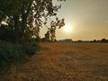
The hash location, setting sun
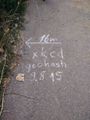
Marker: xkcd and date
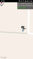
GPS proof


