Difference between revisions of "2015-08-14 49 8"
imported>Elimik31 (Created page with "{{subst:Expedition |lat = 49 |lon = 8 |date = 2015-08-14 }}") |
imported>FippeBot m (Location) |
||
| (7 intermediate revisions by 3 users not shown) | |||
| Line 1: | Line 1: | ||
| − | |||
| − | |||
| − | |||
| − | |||
| − | |||
| − | |||
| − | |||
| − | |||
| − | |||
| − | |||
{{meetup graticule | {{meetup graticule | ||
| lat=49 | | lat=49 | ||
| Line 14: | Line 4: | ||
| date=2015-08-14 | | date=2015-08-14 | ||
}} | }} | ||
| − | |||
| − | |||
| − | |||
== Location == | == Location == | ||
| − | + | Close to the Rhine harbor in Karlsruhe, 10 m from a gravel track in a foresty area. Hopefully it is accessible. | |
== Participants == | == Participants == | ||
| − | + | [[user:elimik31|elimik31]] | |
| − | |||
== Plans == | == Plans == | ||
| − | + | === [[user:elimik31|elimik31]] === | |
| + | |||
| + | I am coming back to my hometown of Karlsruhe about 10 pm. | ||
| + | No guarantee that I will be in time, however this might even become a midnight geohash. | ||
| + | |||
| + | It would be the first with my new Garmin GPS device. The weater forecast promises a thunderstorm, if it is too dangerous I will cancel it. | ||
| + | I fear that the terrain might be swampy. Since this is less than 8 km from home, I want to still try it. | ||
== Expedition == | == Expedition == | ||
| − | |||
| − | + | Wow... So this was really close, timewise. My bus to Karlsruhe came late, which is why I started bicycling to the hash point only at 23:30. | |
| − | + | With a speed of slightly under 30km/h I somehow made it in time. | |
| + | |||
| + | To begin with, it was really frightening to ride this fast on forest tracks in the dark. | ||
| + | The light on my bicycle works really well, but still, I was navigating mostly by my new Garmin GPS device, without seeing much. | ||
| + | Then the last 10m through the forest were really hard. I was walking through dense 2m tall grass-like plants | ||
| + | (I didn't see what exactly they were), the earth was really wet and I could barely move forward, while not even seeing anything. | ||
| + | I felt like in a jungle during midnight. I thought that with every step, I might fall into some water, but I had to hurry. | ||
| + | There were animal sounds, movements in the grass and I felt really helpless... that was my scariest geohashing experience yet. | ||
| + | Luckily, I didn't drop anything, otherwise it would have been near impossible to find. | ||
| + | |||
| + | In the end, I reached the hash coordinates. When I finally changed the settings of the device to show the GPS accuracy, it was already | ||
| + | a minute after 12:00 am, but I think that I was at the geohash coordinates right at midnight. There was no heavy rain or storm as the | ||
| + | weather forecast had promised. I got wet because of the wet grass, but I think that doesn't suffice for the drowned rat achievement. | ||
| + | As a light source I had used a key chain flashlight, but I had to keep turning the generator handle to keep it lit. So it was not | ||
| + | much of a help. | ||
| + | |||
== Photos == | == Photos == | ||
| − | < | + | <gallery perrow="4"> |
| − | Image: | + | Image:2015-08-14_49_8_proof_screenshot.jpg| Screenshot from the Garmin device and proof that I was there. It was taken 5 minutes late. I have been at the approximate location in time at 12 am, but I had to change some setting before taking it and this was difficult in the dark while fearing to drop it. I first tried a photo of the screen with my smartphone, but this turned out blurry as the camera lens got wet. The device is new, so it cost me some time...]] |
| − | + | Image:2015-08-14_49_8_me_wet.jpg| Me on the track 10 m from the geohash location. Here I arrived about 23:56, but the photo was taken after I had reached the hashpoint and returned. I was happy to be back near my bycicle. | |
| − | |||
</gallery> | </gallery> | ||
== Achievements == | == Achievements == | ||
| − | |||
| − | |||
| − | + | * Land Geohash | |
| − | |||
| − | |||
| − | + | {{Midnight geohash | |
| − | + | | latitude = 49 | |
| − | + | | longitude = 8 | |
| − | -- | + | | date = 2015-08-14 |
| − | + | | name = elimik31 | |
| − | + | }} | |
| − | |||
[[Category:Expeditions]] | [[Category:Expeditions]] | ||
| − | |||
[[Category:Expeditions with photos]] | [[Category:Expeditions with photos]] | ||
| − | |||
| − | |||
| − | |||
| − | |||
| − | |||
[[Category:Coordinates reached]] | [[Category:Coordinates reached]] | ||
| − | + | {{location|DE|BW|KA|city=true}} | |
| − | |||
| − | |||
| − | |||
| − | |||
| − | |||
| − | |||
| − | |||
| − | |||
| − | |||
| − | |||
| − | |||
| − | |||
| − | |||
| − | |||
| − | |||
| − | |||
| − | |||
Latest revision as of 04:47, 15 August 2019
| Fri 14 Aug 2015 in 49,8: 49.0077248, 8.3059386 geohashing.info google osm bing/os kml crox |
Location
Close to the Rhine harbor in Karlsruhe, 10 m from a gravel track in a foresty area. Hopefully it is accessible.
Participants
Plans
elimik31
I am coming back to my hometown of Karlsruhe about 10 pm. No guarantee that I will be in time, however this might even become a midnight geohash.
It would be the first with my new Garmin GPS device. The weater forecast promises a thunderstorm, if it is too dangerous I will cancel it. I fear that the terrain might be swampy. Since this is less than 8 km from home, I want to still try it.
Expedition
Wow... So this was really close, timewise. My bus to Karlsruhe came late, which is why I started bicycling to the hash point only at 23:30. With a speed of slightly under 30km/h I somehow made it in time.
To begin with, it was really frightening to ride this fast on forest tracks in the dark. The light on my bicycle works really well, but still, I was navigating mostly by my new Garmin GPS device, without seeing much. Then the last 10m through the forest were really hard. I was walking through dense 2m tall grass-like plants (I didn't see what exactly they were), the earth was really wet and I could barely move forward, while not even seeing anything. I felt like in a jungle during midnight. I thought that with every step, I might fall into some water, but I had to hurry. There were animal sounds, movements in the grass and I felt really helpless... that was my scariest geohashing experience yet. Luckily, I didn't drop anything, otherwise it would have been near impossible to find.
In the end, I reached the hash coordinates. When I finally changed the settings of the device to show the GPS accuracy, it was already a minute after 12:00 am, but I think that I was at the geohash coordinates right at midnight. There was no heavy rain or storm as the weather forecast had promised. I got wet because of the wet grass, but I think that doesn't suffice for the drowned rat achievement. As a light source I had used a key chain flashlight, but I had to keep turning the generator handle to keep it lit. So it was not much of a help.
Photos
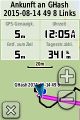
Screenshot from the Garmin device and proof that I was there. It was taken 5 minutes late. I have been at the approximate location in time at 12 am, but I had to change some setting before taking it and this was difficult in the dark while fearing to drop it. I first tried a photo of the screen with my smartphone, but this turned out blurry as the camera lens got wet. The device is new, so it cost me some time...]]

Me on the track 10 m from the geohash location. Here I arrived about 23:56, but the photo was taken after I had reached the hashpoint and returned. I was happy to be back near my bycicle.


Achievements
- Land Geohash
elimik31 earned the Midnight Geohash achievement
|