Difference between revisions of "2015-08-15 53 -2"
imported>Yewbarrow (add land geohash achievement, and categories) |
imported>Yewbarrow (change image sort order, add bicycle geohash achievement) |
||
| Line 47: | Line 47: | ||
Image:8378 track looking west.jpg | looking west along the track - bike helmet marking the spot | Image:8378 track looking west.jpg | looking west along the track - bike helmet marking the spot | ||
Image:8380 track looking east.jpg | looking east along the track - bike helmet marking the spot | Image:8380 track looking east.jpg | looking east along the track - bike helmet marking the spot | ||
| + | Image:8382 fixing a puncture.jpg | fixing my puncture | ||
Image:8381 quarry.jpg | the most (indeed, only) interesting thing visible from the location, what appeared to be a quarry of some type | Image:8381 quarry.jpg | the most (indeed, only) interesting thing visible from the location, what appeared to be a quarry of some type | ||
| − | |||
| − | |||
</gallery> | </gallery> | ||
| Line 63: | Line 62: | ||
| image = 8376 yewbarrow.jpg | | image = 8376 yewbarrow.jpg | ||
}} | }} | ||
| − | + | {{bicycle geohash | |
| − | + | | latitude = 53 | |
| − | + | | longitude = -2 | |
| + | | date = 2015-08-15 | ||
| + | | name = [[user:yewbarrow|yewbarrow]] | ||
| + | | distance = 57km in total | ||
| + | | bothways = true (optional) | ||
| + | | image = 8382 fixing a puncture.jpg | ||
| + | }} | ||
[[Category:Expeditions]] | [[Category:Expeditions]] | ||
[[Category:Expeditions with photos]] | [[Category:Expeditions with photos]] | ||
[[Category:Coordinates reached]] | [[Category:Coordinates reached]] | ||
Revision as of 22:13, 15 August 2015
| Sat 15 Aug 2015 in 53,-2: 53.4134064, -2.4930074 geohashing.info google osm bing/os kml crox |
Location
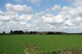
Woodend Lane, between Warrington and Partington. Looks to be just a few metres away from a track / footpath.
Participants
Plans
yewbarrow is hoping to be there at 4pm BST... Never done this before, so let's see if I can get there.
Expedition
It was a sunny day, so was all ideal for a smooth cycle out here from South Manchester. Somewhere soon after starting, I got a slow puncture in the rear tyre. I pumped it up both in Urmston and Partington. Eventually I (yewbarrow) arrived at about 4.03pm... The location turned out to be directly on the farm track / footpath, so very easy to find, without even incurring nettle stings while heading off the path to the north as I originally expected to have to do. After spending ages fixing the puncture, I headed off to find a few geocaches with the remainder of the afternoon.
Tracklog
Photos
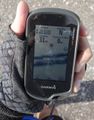
GPS at the location

yewbarrow
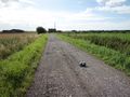
looking west along the track - bike helmet marking the spot
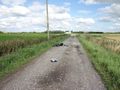
looking east along the track - bike helmet marking the spot
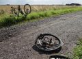
fixing my puncture
the most (indeed, only) interesting thing visible from the location, what appeared to be a quarry of some type


Achievements
yewbarrow earned the Land geohash achievement
|
yewbarrow earned the Bicycle geohash achievement
|