Difference between revisions of "2015-08-17 42 -85"
imported>Mcbaneg (Created page with "<!-- If you did not specify these parameters in the template, please substitute appropriate values for IMAGE, LAT, LON, and DATE (YYYY-MM-DD format) {{{image|dummy.jpg}}}|...") |
imported>Mcbaneg (→Photos) |
||
| Line 39: | Line 39: | ||
--> | --> | ||
<gallery perrow="4"> | <gallery perrow="4"> | ||
| − | Image:2015-08-17 42 - | + | Image:2015-08-17 42 -85_017.png | Proof. |
Image:2015-08-17 42 -85_014.jpg | Grin. | Image:2015-08-17 42 -85_014.jpg | Grin. | ||
Image:2015-08-17 42 -85_012.jpg | View to south from hashpoint. | Image:2015-08-17 42 -85_012.jpg | View to south from hashpoint. | ||
Revision as of 23:55, 18 August 2015

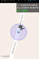
| Mon 17 Aug 2015 in 42,-85: 42.8031303, -85.6664663 geohashing.info google osm bing/os kml crox |
Location
east side of Division Avenue between 84th and 100th Streets, Byron Center, MI
Participants
Expedition
Roadside hashpoint that was easily accessible with a modest detour on the way home from work. I got within GPS error distances very easily, though I couldn't get a reading below 3 m. As best I could figure the wavery and inconsistent GPS wanted me to move east. I refused because of the thicket of poison ivy that was growing on the hillside next to the road.
From the hashpoint I continued to the greengrocer where I found excellent local sweet corn for $3/dozen. Rejoice with me.
Photos
Proof.

Grin.
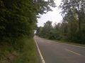
View to south from hashpoint.
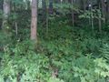
I consider myself a dedicated geohasher - blackberry brambles do not deter me - but I am NOT hashdancing in this stuff.
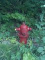
I guess firemen generally have thick clothes and tall boots and worse occupational hazards than poison ivy, so maybe they don't mind.


