Difference between revisions of "2015-08-24 50 8"
From Geohashing
imported>Tads (Created page with "{{subst:Expedition |lat = 50 |lon = 8 |date = 2015-08-24 }}") |
imported>FippeBot m (Location) |
||
| (2 intermediate revisions by one other user not shown) | |||
| Line 1: | Line 1: | ||
| − | |||
| − | |||
| − | |||
| − | |||
| − | |||
| − | |||
| − | |||
| − | |||
| − | |||
| − | |||
{{meetup graticule | {{meetup graticule | ||
| lat=50 | | lat=50 | ||
| Line 19: | Line 9: | ||
== Location == | == Location == | ||
| − | + | on a small path in Schwalbach near Frankfurt | |
== Participants == | == Participants == | ||
| − | + | [[User:Tads|Tads]] ([[User talk:Tads|talk]]) | |
| − | |||
== Plans == | == Plans == | ||
| − | + | I will come through Frankfurt with the train anyway, so I'll take a detour to catch the geohash. | |
== Expedition == | == Expedition == | ||
| − | + | As planned, I got off my train in Frankfurt-West to take the S-Bahn to Niederhöchstadt. From there it was only a short walk to the hashpoint. | |
| + | It was located just at the border of "Schwalbach im Taunus" close to Frankfurt. | ||
| − | + | The weather was really bad, but at least I had the rain jacket with me which kept me dry on the inside. After quickly taking the necessary pictures, I went back to the S-Bahn station from where I continued my travel home to Darmstadt. | |
| − | |||
== Photos == | == Photos == | ||
| − | < | + | <gallery perrow="3"> |
| − | Image: | + | Image:tads_2015-08-24_50_8_proof.png | GPS proof |
| − | -- | + | Image:tads_2015-08-24_50_8_path.jpg | Path to the hash location. |
| − | + | Image:tads_2015-08-24_50_8_spot.jpg | Slight mark on the ground. | |
</gallery> | </gallery> | ||
| Line 45: | Line 34: | ||
<!-- Add any achievement ribbons you earned below, or remove this section --> | <!-- Add any achievement ribbons you earned below, or remove this section --> | ||
| − | |||
| − | |||
| − | |||
| − | |||
| − | |||
| − | |||
| − | |||
| − | |||
| − | |||
| − | |||
| − | |||
[[Category:Expeditions]] | [[Category:Expeditions]] | ||
| − | |||
[[Category:Expeditions with photos]] | [[Category:Expeditions with photos]] | ||
| − | |||
| − | |||
| − | |||
| − | |||
| − | |||
[[Category:Coordinates reached]] | [[Category:Coordinates reached]] | ||
| − | + | {{location|DE|HE|MTK}} | |
| − | |||
| − | |||
| − | |||
| − | |||
| − | |||
| − | |||
| − | |||
| − | |||
| − | |||
| − | |||
| − | |||
| − | |||
| − | |||
| − | |||
| − | |||
| − | |||
| − | |||
Latest revision as of 04:54, 15 August 2019
| Mon 24 Aug 2015 in 50,8: 50.1513459, 8.5444568 geohashing.info google osm bing/os kml crox |
Location
on a small path in Schwalbach near Frankfurt
Participants
Plans
I will come through Frankfurt with the train anyway, so I'll take a detour to catch the geohash.
Expedition
As planned, I got off my train in Frankfurt-West to take the S-Bahn to Niederhöchstadt. From there it was only a short walk to the hashpoint. It was located just at the border of "Schwalbach im Taunus" close to Frankfurt.
The weather was really bad, but at least I had the rain jacket with me which kept me dry on the inside. After quickly taking the necessary pictures, I went back to the S-Bahn station from where I continued my travel home to Darmstadt.
Photos
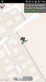
GPS proof
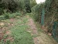
Path to the hash location.
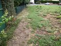
Slight mark on the ground.


