Difference between revisions of "2015-09-11 49 7"
From Geohashing
imported>Strongblackcoffee |
imported>FippeBot m (Location) |
||
| (3 intermediate revisions by 2 users not shown) | |||
| Line 1: | Line 1: | ||
<!-- If you did not specify these parameters in the template, please substitute appropriate values for IMAGE, LAT, LON, and DATE (YYYY-MM-DD format) | <!-- If you did not specify these parameters in the template, please substitute appropriate values for IMAGE, LAT, LON, and DATE (YYYY-MM-DD format) | ||
| − | |||
| − | |||
Remove this section if you don't want an image at the top (left) of your report. You should remove the "Image:" or "File:" | Remove this section if you don't want an image at the top (left) of your report. You should remove the "Image:" or "File:" | ||
| Line 39: | Line 37: | ||
--> | --> | ||
<gallery perrow="5"> | <gallery perrow="5"> | ||
| − | Image: Geohash-2015-09-11_49_7.jpg | | + | Image: Geohash-2015-09-11_49_7.jpg | the proof is in the pudding. |
</gallery> | </gallery> | ||
| − | |||
| − | |||
| − | |||
| − | |||
| − | |||
| − | |||
| − | |||
| − | |||
| − | |||
| − | |||
| − | |||
| − | |||
[[Category:Expeditions]] | [[Category:Expeditions]] | ||
| − | |||
[[Category:Expeditions with photos]] | [[Category:Expeditions with photos]] | ||
| − | |||
| − | |||
| − | |||
| − | |||
| − | |||
[[Category:Coordinates reached]] | [[Category:Coordinates reached]] | ||
| − | + | {{location|DE|SL|WND}} | |
| − | |||
| − | |||
| − | |||
| − | |||
| − | |||
| − | |||
| − | |||
| − | |||
| − | |||
| − | |||
| − | |||
| − | |||
| − | |||
| − | |||
| − | |||
| − | |||
| − | |||
Latest revision as of 01:18, 7 August 2019
| Fri 11 Sep 2015 in 49,7: 49.4925934, 7.2019514 geohashing.info google osm bing/os kml crox |
Location
On a field near Leitersweiler.
Participants
Plans
My first ever geohash. As I wasn't sure what to expect, I organized to have three fellow geocachers budding along, and we planed a few caches along the way...
Expedition
We found it, on the edge of a field. It was already dark. Afterwards, we found a geocache in an old WW2 Nazi bunker. Awesome adventure!
Photos
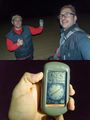
the proof is in the pudding.
