Difference between revisions of "2015-10-09 51 13"
imported>Danatar (An expedition message sent via Geohash Droid for Android.) |
imported>FippeBot m (Location) |
||
| (4 intermediate revisions by one other user not shown) | |||
| Line 1: | Line 1: | ||
| − | |||
| − | |||
| − | |||
| − | |||
| − | |||
| − | |||
| − | |||
| − | |||
| − | |||
| − | |||
{{meetup graticule | {{meetup graticule | ||
| lat=51 | | lat=51 | ||
| Line 14: | Line 4: | ||
| date=2015-10-09 | | date=2015-10-09 | ||
}} | }} | ||
| − | |||
| − | |||
__NOTOC__ | __NOTOC__ | ||
== Location == | == Location == | ||
| − | + | Today's location is on or next to a small road near a subdivision of Großschirma, not far from the Autobahn A4. | |
| + | |||
| + | Country: Germany; State: Sachsen; District: Mittelsachsen. | ||
| + | |||
== Participants == | == Participants == | ||
| − | + | [[User:Danatar|Danatar]] | |
| − | |||
| − | |||
| − | |||
== Expedition == | == Expedition == | ||
| − | + | I was on my way back from a training in Zwickau. This hashpoint was not far from the Autobahn, which I left at the Berbersdorf exit. Two exits earlier would have been much better, because there was a traffic jam. I drove along small and not-so-small country roads through Goßberg and Reichenbach, before I turned into the small road that went to the hashpoint. I stopped the car on a small patch of grass about 10 meters from the hashpoint, next to a small creek. Reaching the spot was not easy because it kept evading me. I reached the coordinates a bit north of the road, about 2 meters in the underbrush. Only a short bit later it was one meter south of the road. | |
| + | |||
| + | *Coordinates reached! -- [[User:Danatar|Danatar]] ([[User talk:Danatar|talk]]) [http://www.openstreetmap.org/?lat=51.00493495&lon=13.30140375&zoom=16&layers=B000FTF @51.0049,13.3014] 17:58, 9 October 2015 (CEST) | ||
| + | |||
| + | Not staying long, I hopped back into the car and started to drive back along the road. When I drove alongside a cow pasture, all the cows came towards me, so I stopped again and petted the one that came nearest to the fence. I would have stayed longer, but there was a car coming down the road behind me and I didn't want to block the narrow road. Only a short while later I was back on the Autobahn, driving to Dresden. | ||
| − | |||
| − | |||
| − | |||
| − | |||
| − | |||
| − | |||
<gallery perrow="5"> | <gallery perrow="5"> | ||
| + | Image:2015-10-09_51_13_near.jpg|almost there | ||
| + | Image:2015-10-09_51_13_gps.jpg|GPS | ||
| + | Image:2015-10-09_51_13_hp.jpg|coordinates reached | ||
| + | Image:2015-10-09_51_13_spot.jpg|hashpoint (one version) | ||
| + | Image:2015-10-09_51_13_pano.jpg|panorama | ||
| + | Image:2015-10-09_51_13_bach.jpg|the nearby creek | ||
| + | Image:2015-10-09_51_13_kuh1.jpg|cows coming | ||
| + | Image:2015-10-09_51_13_kuh2.jpg|cows watching | ||
| + | Image:2015-10-09_51_13_kuh3.jpg|cow eating | ||
</gallery> | </gallery> | ||
| + | Somehow my camera was set to a fixed ISO-100 setting, so the pictures are all a bit dark and blurred. | ||
| − | |||
| − | |||
| − | |||
| − | + | == Tracklog == | |
| − | + | [http://www.everytrail.com/view_trip.php?trip_id=3409898&code=15616cee4a42333d759c8c3182e8cf08 Triton tracklog] | |
| − | |||
| − | |||
| − | |||
| − | |||
| − | |||
| − | |||
| − | |||
[[Category:Expeditions]] | [[Category:Expeditions]] | ||
| − | |||
[[Category:Expeditions with photos]] | [[Category:Expeditions with photos]] | ||
| − | |||
| − | |||
| − | |||
| − | |||
| − | |||
[[Category:Coordinates reached]] | [[Category:Coordinates reached]] | ||
| − | + | [[Category:Danatar]] | |
| − | + | {{location|DE|SN|FG}} | |
| − | |||
| − | |||
| − | |||
| − | |||
| − | |||
| − | |||
| − | |||
| − | |||
| − | |||
| − | |||
| − | [[Category: | ||
| − | |||
| − | |||
| − | |||
| − | |||
| − | |||
Latest revision as of 05:23, 15 August 2019
| Fri 9 Oct 2015 in 51,13: 51.0049153, 13.3013955 geohashing.info google osm bing/os kml crox |
Location
Today's location is on or next to a small road near a subdivision of Großschirma, not far from the Autobahn A4.
Country: Germany; State: Sachsen; District: Mittelsachsen.
Participants
Expedition
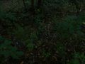
I was on my way back from a training in Zwickau. This hashpoint was not far from the Autobahn, which I left at the Berbersdorf exit. Two exits earlier would have been much better, because there was a traffic jam. I drove along small and not-so-small country roads through Goßberg and Reichenbach, before I turned into the small road that went to the hashpoint. I stopped the car on a small patch of grass about 10 meters from the hashpoint, next to a small creek. Reaching the spot was not easy because it kept evading me. I reached the coordinates a bit north of the road, about 2 meters in the underbrush. Only a short bit later it was one meter south of the road.
- Coordinates reached! -- Danatar (talk) @51.0049,13.3014 17:58, 9 October 2015 (CEST)
Not staying long, I hopped back into the car and started to drive back along the road. When I drove alongside a cow pasture, all the cows came towards me, so I stopped again and petted the one that came nearest to the fence. I would have stayed longer, but there was a car coming down the road behind me and I didn't want to block the narrow road. Only a short while later I was back on the Autobahn, driving to Dresden.
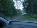
almost there
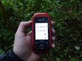
GPS
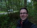
coordinates reached
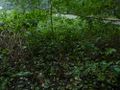
hashpoint (one version)

panorama
the nearby creek
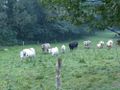
cows coming
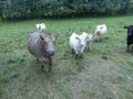
cows watching
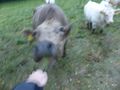
cow eating


Somehow my camera was set to a fixed ISO-100 setting, so the pictures are all a bit dark and blurred.