Difference between revisions of "2015-10-13 50 11"
imported>FriedrichFröbel |
imported>Sourcerer m (/* Sorted out the categories /*) |
||
| Line 34: | Line 34: | ||
</gallery> | </gallery> | ||
| − | |||
| − | |||
| − | |||
| − | |||
| − | |||
| − | |||
| − | |||
| − | |||
| − | |||
| − | |||
| − | |||
| − | |||
[[Category:Expeditions]] | [[Category:Expeditions]] | ||
| − | |||
[[Category:Expeditions with photos]] | [[Category:Expeditions with photos]] | ||
| − | |||
| − | |||
| − | |||
| − | |||
| − | |||
[[Category:Coordinates reached]] | [[Category:Coordinates reached]] | ||
| − | |||
| − | |||
| − | |||
| − | |||
| − | |||
| − | |||
| − | |||
| − | |||
| − | |||
| − | |||
| − | |||
| − | |||
| − | |||
| − | |||
| − | |||
| − | |||
| − | |||
| − | |||
Revision as of 18:20, 13 October 2015
| Tue 13 Oct 2015 in 50,11: 50.6963171, 11.3149675 geohashing.info google osm bing/os kml crox |
Location
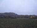
It is situated in a part of the Thuringian town Rudolstadt on the way to Zeigerheim. Next to the ground zero there is a small road. The ground zero itself is on a field which was wet and muddy - probably caused by the current weather conditions.
Expedition
FriedrichFröbel
Geohashing - a big mystery we always wanted to do some day. But every time such a point appeared it was not possible for us to visit it. Until today when everything fitted well.
But before going outdoors, we had to read about the special requirements needed to be able to post an entry of our visit. After doing this, we started our way to our first Geohash very early.
With only 1 °C on the thermometer we drove to the point of interest where we had to get a GPS position - not very easy when you are using a mobile phone. But after waiting for some time, this problem was solved and a new one appeared: We were not able to get to the exact coordinates - even after some time and lots of movements. So we finally decided to let the exact coordinates be the exact ones and decided to pin it on the inaccuracy of the mobile phone’s location recognition.
But let us change to the location itself again. It is situated in a part of the Thuringian town Rudolstadt on the way to Zeigerheim. Next to the ground zero there is a small road. The ground zero itself is on a field which was wet and muddy - probably caused by the current weather conditions.
As already mentioned we decided to go back home after we had waited for around 30 minutes. Our hands were blue and numb - we hope our next Geohash will give us the opportunity to visit it at higher temperatures.
Photos

Ground zero near the street
Foggy view in the dark
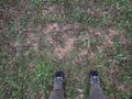
At ground zero
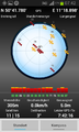
Coordinates


