Difference between revisions of "2015-11-08 47 11"
imported>TheOneRing (Created page with "{{meetup graticule | lat=47 | lon=11 | date=2015-11-08 }} == Location == The geohash is on a meadow between Raisting and Pähl. == Who Went == *[[User:TheOneRing|TheOneRing]...") |
imported>TheOneRing |
||
| Line 30: | Line 30: | ||
== Photos == | == Photos == | ||
=== TheOneRing === | === TheOneRing === | ||
| − | <gallery perrow=" | + | <gallery perrow="4"> |
| − | Image: | + | Image:20151108_47_11GPS.jpg|Coordinates reached |
| − | + | Image:20151108_47_11Info.jpg|Some more information | |
| − | Image: | + | Image:20151108_47_11Geohash.jpg|Here it is |
| − | Image: | + | Image:20151108_47_11Me.jpg|The hasher |
| − | Image: | ||
| − | |||
</gallery> | </gallery> | ||
Revision as of 19:53, 8 November 2015
| Sun 8 Nov 2015 in 47,11: 47.9053471, 11.1586973 geohashing.info google osm bing/os kml crox |
Contents
Location
The geohash is on a meadow between Raisting and Pähl.
Who Went
- TheOneRing - walking.
The Expedition
TheOneRing
This geohash was once again in walking distance: 6.3km as the bird flies. Naturally, streets don't go that way, so in the end it was about 9.2km one way, 18.5km in total.
But first things first. Last week I was in Switzerland, without the opportunity to go geohashing in my old home graticule. Seeing the close geohash today, this was more than an option.
I was thinking about going by bike and eventually decided in favour of walking. The weather was nice, sunny and up to 20°C, which is unusual for beginning of November.
I started at 11am, and headed towards Raisting. Raisting, you say? I heard that before, and you are right. First part of the tour was identical to one geohash last year. At the entry of Raisting, I left that route and walked along harvested fields. Many people were going by bike or horse and used the nice weather like me.
With about 1km to go I had to walk next to a street with frequent traffic but the shoulders were dry and easy to walk on.
At the geohash, I had a small rest and took the usual photographs. I was thinking about taking a different way back home, but I wanted to take more photos of the scenery.
On my way back, I was overtaken by three riders on horses, which might be an interesting idea for an upcoming geohash. (I have never ridden yet, which is a problem.)
A very nice tour today, and a good act of sports (at least my legs think so).
Photos
TheOneRing
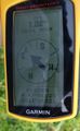
Coordinates reached
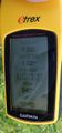
Some more information
Here it is

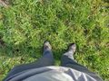
The hasher


Achievements
TheOneRing earned the Land geohash achievement
|
TheOneRing earned the Walk geohash Achievement
|