Difference between revisions of "2015-11-12 47 8"
From Geohashing
imported>Lysogeny (→Plans) |
imported>Lysogeny |
||
| Line 37: | Line 37: | ||
== Expedition == | == Expedition == | ||
<!-- how it all turned out. your narrative goes here. --> | <!-- how it all turned out. your narrative goes here. --> | ||
| − | + | Due to time constraints I unfortunately can not do this. | |
== Tracklog == | == Tracklog == | ||
<!-- if your GPS device keeps a log, you may post a link here --> | <!-- if your GPS device keeps a log, you may post a link here --> | ||
| Line 57: | Line 57: | ||
<!-- Potential categories. Please include all the ones appropriate to your expedition --> | <!-- Potential categories. Please include all the ones appropriate to your expedition --> | ||
| − | + | [[Category:Not reached - Did not attempt]] | |
| − | |||
| − | |||
| − | |||
<!-- An actual expedition: | <!-- An actual expedition: | ||
Revision as of 11:11, 12 November 2015
| Thu 12 Nov 2015 in 47,8: 47.6691404, 8.8565536 geohashing.info google osm bing/os kml crox |
Location
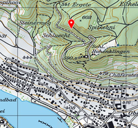
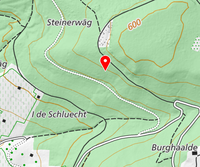
Hillside forest by Stein am Rhein, Switzerland
Participants
Plans
The hash seems to be on a hill-side. The incline should not be too steep, so it should be possible to reach the hash. The hash is also located between two roads, allowing an alternate vector if one of the roads should have the hash inaccessible.
Expedition
Due to time constraints I unfortunately can not do this.
Tracklog
Photos
Achievements

