Difference between revisions of "2015-11-15 27 -15"
From Geohashing
imported>Draradech (Created page with "{{meetup graticule | lat=27 | lon=-15 | date=2015-11-15}} __NOTOC__ == Location == Very close to a satellite control station of [https://en.wikipedia.org/wiki/Instituto_Naci...") |
imported>FippeBot m (Location) |
||
| (2 intermediate revisions by one other user not shown) | |||
| Line 4: | Line 4: | ||
== Location == | == Location == | ||
| − | Very close to a satellite control station of [https://en.wikipedia.org/wiki/Instituto_Nacional_de_T%C3%A9cnica_Aeroespacial INTA] (Spanish Space Agency). Luckily not | + | Very close to a satellite control station of [https://en.wikipedia.org/wiki/Instituto_Nacional_de_T%C3%A9cnica_Aeroespacial INTA] (Spanish Space Agency). Luckily not in the fenced area. |
== Participants == | == Participants == | ||
| Line 18: | Line 18: | ||
== Photos == | == Photos == | ||
<gallery perrow="6"> | <gallery perrow="6"> | ||
| − | Image:2015-11-15_27_-15_hash.jpg | | + | Image:2015-11-15_27_-15_hash.jpg | View from the hash |
Image:2015-11-15_27_-15_grin.jpg | Stupid grin | Image:2015-11-15_27_-15_grin.jpg | Stupid grin | ||
Image:2015-11-15_27_-15_proof.jpg | Reached | Image:2015-11-15_27_-15_proof.jpg | Reached | ||
| Line 29: | Line 29: | ||
[[Category:Expeditions with photos]] | [[Category:Expeditions with photos]] | ||
[[Category:Coordinates reached]] | [[Category:Coordinates reached]] | ||
| + | {{location|ES|CN|GC}} | ||
Latest revision as of 05:50, 15 August 2019
| Sun 15 Nov 2015 in 27,-15: 27.7606843, -15.6327538 geohashing.info google osm bing/os kml crox |
Location
Very close to a satellite control station of INTA (Spanish Space Agency). Luckily not in the fenced area.
Participants
- Draradech
- bilbo_b
Plans
Second hash on holiday, looks reachable. Not that far from our hotel as well.
Expedition
We planned to drive near the hash site, and just walk the last few meters. That didn't work out, the access road is for vehicles with permit only. No word about walking, though. So we parked the car and went the last km or so by foot (I always underestimate elevation changes, looks flat on the satellite image, but really isn't...). A lot of parabolic antennas and one for radar (it was spinning...)?
Photos
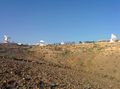
View from the hash

Stupid grin
Reached


Achievements
1 of 2 consecutive hashes, next: 2015-11-16_28_-15