Difference between revisions of "2015-12-06 51 9"
From Geohashing
imported>GeorgDerReisende (new report) |
imported>FippeBot m (Location) |
||
| (One intermediate revision by one other user not shown) | |||
| Line 1: | Line 1: | ||
| − | |||
| − | |||
| − | |||
| − | |||
| − | |||
| − | |||
| − | |||
| − | |||
| − | |||
| − | |||
{{meetup graticule | {{meetup graticule | ||
| lat=51 | | lat=51 | ||
| Line 19: | Line 9: | ||
== Location == | == Location == | ||
| − | + | ||
| + | The hash lay on the (wrong) side of the rivulet Esse near Burguffeln. | ||
== Participants == | == Participants == | ||
| − | + | ||
| − | + | [[User:GeorgDerReisende|GeorgDerReisende]] | |
== Plans == | == Plans == | ||
| − | + | ||
| + | Plans? I will go. | ||
== Expedition == | == Expedition == | ||
| − | |||
| − | + | I left home at 10 o'clock, took the trams 7 and RT 4 and the bus 100 to Schäferberg. Then I hitchhiked for 4.3 kilometers. I walked to the hash, passed a watermill, and arrived at the wrong side of the rivulet Esse. 11 meters too far away on the other side. | |
| − | |||
== Photos == | == Photos == | ||
| − | |||
| − | |||
| − | |||
<gallery perrow="5"> | <gallery perrow="5"> | ||
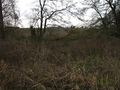
| + | Image:2015-12-06 51 9 GeorgDerReisende 7396.jpg | somewhere down in the valley | ||
| + | Image:2015-12-06 51 9 GeorgDerReisende 7397.jpg | the Lindenmühle | ||
| + | Image:2015-12-06 51 9 GeorgDerReisende 7402.jpg | the mill is running | ||
| + | Image:2015-12-06 51 9 GeorgDerReisende 7411.jpg | 28 meters to go | ||
| + | Image:2015-12-06 51 9 GeorgDerReisende 7414.jpg | 11 meters to go, the hash is at the fallen tree | ||
| + | Image:2015-12-06 51 9 GeorgDerReisende 7415.jpg | proof | ||
| + | Image:2015-12-06 51 9 GeorgDerReisende 7416.jpg | no luck today | ||
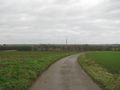
| + | Image:2015-12-06 51 9 GeorgDerReisende 7423.jpg | I could walk along the field for 350 meters | ||
| + | Image:2015-12-06 51 9 GeorgDerReisende 7425.jpg | view to Burguffeln | ||
</gallery> | </gallery> | ||
| − | + | [[Category:Expeditions]] | |
| − | |||
| − | |||
| − | |||
| − | |||
| − | |||
| − | |||
| − | |||
| − | |||
| − | |||
| − | |||
| − | |||
| − | |||
| − | |||
| − | |||
| − | |||
| − | |||
[[Category:Expeditions with photos]] | [[Category:Expeditions with photos]] | ||
| − | |||
| − | |||
| − | |||
| − | |||
| − | |||
| − | |||
| + | [[Category:Coordinates not reached]] | ||
| − | |||
| − | |||
| − | |||
| − | |||
[[Category:Not reached - Mother Nature]] | [[Category:Not reached - Mother Nature]] | ||
| − | + | {{location|DE|HE|KS}} | |
| − | |||
| − | |||
| − | |||
| − | |||
| − | |||
| − | |||
| − | |||
| − | |||
| − | |||
| − | |||
Latest revision as of 06:04, 15 August 2019
| Sun 6 Dec 2015 in 51,9: 51.4338856, 9.4378608 geohashing.info google osm bing/os kml crox |
Location
The hash lay on the (wrong) side of the rivulet Esse near Burguffeln.
Participants
Plans
Plans? I will go.
Expedition
I left home at 10 o'clock, took the trams 7 and RT 4 and the bus 100 to Schäferberg. Then I hitchhiked for 4.3 kilometers. I walked to the hash, passed a watermill, and arrived at the wrong side of the rivulet Esse. 11 meters too far away on the other side.
Photos
somewhere down in the valley
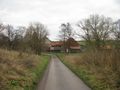
the Lindenmühle
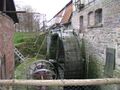
the mill is running
28 meters to go
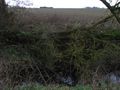
11 meters to go, the hash is at the fallen tree
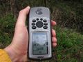
proof

no luck today
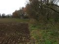
I could walk along the field for 350 meters
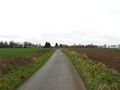
view to Burguffeln


