Difference between revisions of "2015-10-26 -38 144"
From Geohashing
imported>Benkaiser (Created page with "{{meetup graticule | lat=-38 | lon=144 | date=2015-10-26 }} == Location == In a paddock near Deans Marsh == Participants == Benjamin Kaiser Joel...") |
imported>FippeBot m (Location) |
||
| Line 36: | Line 36: | ||
[[Category:Expeditions with photos]] | [[Category:Expeditions with photos]] | ||
[[Category:Coordinates reached]] | [[Category:Coordinates reached]] | ||
| + | {{location|AU|VIC}} | ||
Revision as of 05:35, 15 August 2019
| Mon 26 Oct 2015 in -38,144: -38.3502114, 144.1396364 geohashing.info google osm bing/os kml crox |
Location
In a paddock near Deans Marsh
Participants
Joelle Wilder
Expedition
We decided to drive down to make it to the geohash, was a cruisy 30 minute drive on a beautiful day. Upon arriving we walked 250m into a field and arrived at the hashpoint with a lovely view of some sheep not far off. We then spent the rest of the afternoon with a drive down to Lorne.
Photos
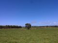
View from the hashpoint
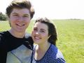
Selfie of Joelle and I
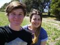
Selfie of Joelle and I + fly on my face
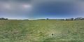
Photosphere of the road at the hashpoint
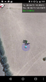
Screenshot at geohash


