Difference between revisions of "2015-12-27 49 8"
imported>DODO (→Expedition) |
imported>FippeBot m (Location) |
||
| (9 intermediate revisions by one other user not shown) | |||
| Line 29: | Line 29: | ||
== Plans == | == Plans == | ||
<!-- what were the original plans --> | <!-- what were the original plans --> | ||
| + | Maybe I have some time during a rowing expedition from Mannheim-Rheinau to Speyer. | ||
== Expedition == | == Expedition == | ||
<!-- how it all turned out. your narrative goes here. --> | <!-- how it all turned out. your narrative goes here. --> | ||
| − | + | As gracious the geohash god had been yesterday as cruel has (s)he been today. (S)he had chosen a place so close to my home like never before in the last two years. And I had hardly any time. | |
| + | |||
| + | I had planned to row from Mannheim-Rheinau to Speyer and back today with some friends of mine. We started to early (or I got out of bed to late) so I couldn't go to the hash before. At 10:30 we started rowing. The rhine is very low at the moment and when we just have left our harbor a big ship came along and made big waves. Usually these waves don't harm rowing boats but the water was so shallow that the waves broke and so we all got wet. Not very comfortable at this season although the weather was unusual warm. 4 kilometers later the same thing happened again and we had to stop in the Otterstädter Altrhein to empty our boat. But the rest of the tour to Speyer was pleasant and we arrived at 1 pm. We walked to the restaurant and to my surprise this was only 200 m away from todays hashpoint. So after dinner I told my companions about geohashing and that I had to go for a little walk. Dinner did last longer than expected and we had to hurry to come home before it was getting dark. Because of that my comrades couldn't come along with me. | ||
| + | |||
| + | So I quickly walked the 200m to the hash, took some pictures and hurried back to the place where we left our boat. We put it back into the water and rowed the way back to our club where we arrived at a quarter to five, one hour after we had left Speyer again. | ||
== Tracklog == | == Tracklog == | ||
<!-- if your GPS device keeps a log, you may post a link here --> | <!-- if your GPS device keeps a log, you may post a link here --> | ||
| + | [http://www.gpsies.com/map.do?fileId=xzjkjbhldlvaisgq 34 KM rowing and 1 KM walking] | ||
== Photos == | == Photos == | ||
| Line 42: | Line 48: | ||
--> | --> | ||
<gallery perrow="5"> | <gallery perrow="5"> | ||
| + | Image:2015-12-27_49_8-1.jpg|3 of my companions | ||
| + | Image:2015-12-27_49_8-2.jpg|the other two | ||
| + | Image:2015-12-27_49_8-3.jpg|behind the donkey | ||
| + | Image:2015-12-27_49_8-9.png|proof | ||
| + | Image:2015-12-27_49_8-4.jpg|view to the west | ||
| + | Image:2015-12-27_49_8-5.jpg|the east | ||
| + | Image:2015-12-27_49_8-6.jpg|the south | ||
| + | Image:2015-12-27_49_8-7.jpg|the north | ||
| + | Image:2015-12-27_49_8-8.jpg|the hasher | ||
</gallery> | </gallery> | ||
| Line 47: | Line 62: | ||
{{#vardefine:ribbonwidth|800px}} | {{#vardefine:ribbonwidth|800px}} | ||
<!-- Add any achievement ribbons you earned below, or remove this section --> | <!-- Add any achievement ribbons you earned below, or remove this section --> | ||
| + | {{land geohash | ||
| + | | latitude = 49 | ||
| + | | longitude = 8 | ||
| + | | date = 2015-12-27 | ||
| + | | name = DODO | ||
| + | }} | ||
| − | |||
| − | |||
| − | |||
| − | + | {{consecutive geohash | |
| − | + | | count = 2 | |
| − | + | | latitude = 49 | |
| − | + | | longitude = 8 | |
| + | | date = 2015-12-26 | ||
| + | | name = DODO | ||
| + | }} | ||
| − | + | There is no achievement for rowing to a hashpoint (if you don't reach the hp on the boat), and of course I had to drive to the rowing club by car so that that wouldn't have counted anyway. | |
| − | |||
[[Category:Expeditions]] | [[Category:Expeditions]] | ||
| − | + | ||
[[Category:Expeditions with photos]] | [[Category:Expeditions with photos]] | ||
| − | + | ||
| − | |||
| − | |||
| − | |||
| − | |||
[[Category:Coordinates reached]] | [[Category:Coordinates reached]] | ||
| − | + | {{location|DE|RP|SP}} | |
| − | |||
| − | |||
| − | |||
| − | |||
| − | |||
| − | |||
| − | |||
| − | |||
| − | |||
| − | |||
| − | |||
| − | |||
| − | |||
| − | |||
| − | |||
| − | |||
| − | |||
Latest revision as of 06:15, 15 August 2019
| Sun 27 Dec 2015 in 49,8: 49.3222562, 8.4434902 geohashing.info google osm bing/os kml crox |
Location
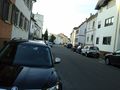
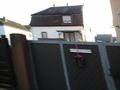
In the road Hinterm Esel (Behind the donkey) in Speyer.
Participants
Plans
Maybe I have some time during a rowing expedition from Mannheim-Rheinau to Speyer.
Expedition
As gracious the geohash god had been yesterday as cruel has (s)he been today. (S)he had chosen a place so close to my home like never before in the last two years. And I had hardly any time.
I had planned to row from Mannheim-Rheinau to Speyer and back today with some friends of mine. We started to early (or I got out of bed to late) so I couldn't go to the hash before. At 10:30 we started rowing. The rhine is very low at the moment and when we just have left our harbor a big ship came along and made big waves. Usually these waves don't harm rowing boats but the water was so shallow that the waves broke and so we all got wet. Not very comfortable at this season although the weather was unusual warm. 4 kilometers later the same thing happened again and we had to stop in the Otterstädter Altrhein to empty our boat. But the rest of the tour to Speyer was pleasant and we arrived at 1 pm. We walked to the restaurant and to my surprise this was only 200 m away from todays hashpoint. So after dinner I told my companions about geohashing and that I had to go for a little walk. Dinner did last longer than expected and we had to hurry to come home before it was getting dark. Because of that my comrades couldn't come along with me.
So I quickly walked the 200m to the hash, took some pictures and hurried back to the place where we left our boat. We put it back into the water and rowed the way back to our club where we arrived at a quarter to five, one hour after we had left Speyer again.
Tracklog
Photos
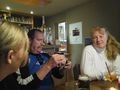
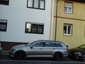
3 of my companions
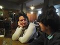
the other two
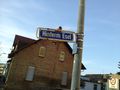
behind the donkey
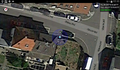
proof
view to the west
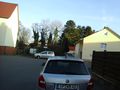
the east
the south
the north
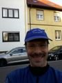
the hasher


Achievements
DODO earned the Land geohash achievement
|
DODO earned the Consecutive geohash achievement
|
There is no achievement for rowing to a hashpoint (if you don't reach the hp on the boat), and of course I had to drive to the rowing club by car so that that wouldn't have counted anyway.