Difference between revisions of "2015-12-28 47 -122"
From Geohashing
imported>Thomcat ([live picture]Creek from the other end [http://www.openstreetmap.org/?lat=47.79390940&lon=-122.32867760&zoom=16&layers=B000FTF @47.7939,-122.3287]) |
imported>Thomcat ([live picture]Creekside church [http://www.openstreetmap.org/?lat=47.79406860&lon=-122.32848140&zoom=16&layers=B000FTF @47.7941,-122.3285]) |
||
| Line 36: | Line 36: | ||
Image:2015-12-28_47_-122_thomcat_1451348859949.jpg|Creek from the other end [http://www.openstreetmap.org/?lat=47.79390940&lon=-122.32867760&zoom=16&layers=B000FTF @47.7939,-122.3287] | Image:2015-12-28_47_-122_thomcat_1451348859949.jpg|Creek from the other end [http://www.openstreetmap.org/?lat=47.79390940&lon=-122.32867760&zoom=16&layers=B000FTF @47.7939,-122.3287] | ||
| + | |||
| + | Image:2015-12-28_47_-122_thomcat_1451348925428.jpg|Creekside church [http://www.openstreetmap.org/?lat=47.79406860&lon=-122.32848140&zoom=16&layers=B000FTF @47.7941,-122.3285] | ||
</gallery> | </gallery> | ||
Revision as of 00:28, 29 December 2015
| Mon 28 Dec 2015 in Seattle: 47.7939146, -122.3286676 geohashing.info google osm bing/os kml crox |
Location
A creek next to a church parking lot just north of Lake Ballinger.
Participants
Plans
Stop by after work, hopefully during daylight (sunset is at 4:24 pm)
Expedition
Tracklog
Photos
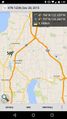
Hopefully the last screenshot I need for geohashing
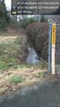
The creek @47.7936,-122.3291

geohasher @47.7939,-122.3287
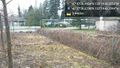
Creek from the other end @47.7939,-122.3287
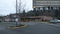
Creekside church @47.7941,-122.3285


Achievements