Difference between revisions of "2016-01-05 52 0"
From Geohashing
imported>Sourcerer m (→Planning) |
imported>Sourcerer m ([live picture] Arrival proof. [http://www.openstreetmap.org/?lat=52.10113764&lon=.92408538&zoom=16&layers=B000FTF @52.1011,.9241]) |
||
| Line 25: | Line 25: | ||
== Photos == | == Photos == | ||
<gallery> | <gallery> | ||
| + | |||
| + | Image:2016-01-05_52_0_Sourcerer_1451954157088.jpg | Arrival proof. [http://www.openstreetmap.org/?lat=52.10113764&lon=.92408538&zoom=16&layers=B000FTF @52.1011,.9241] | ||
</gallery> | </gallery> | ||
Revision as of 00:37, 5 January 2016
| Tue 5 Jan 2016 in Cambridge, UK: 52.1011510, 0.9241040 geohashing.info google osm bing/os kml crox |
Location
4) In a field between Nedging and Nedging Tye, Suffolk, UK.
Participants
Plans
Expedition four of four spanning midnight - 2015-11-08 52 1 Retro - 2016-01-04 52 1 - 2016-01-04 51 1 - 2016-01-05 52 0 - ETA 00:00.
Expedition
Photos
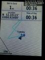
Arrival proof. @52.1011,.9241

Achievements
Expeditions and Plans
| 2016-01-05 | ||
|---|---|---|
| Cambridge, United Kingdom | Sourcerer | 4) In a field between Nedging and Nedging Tye, Suffolk, UK. |
| Amsterdam, Netherlands | JwB | A field between Harmelen and Woerden |
Sourcerer's Expedition Links
2016-01-04 51 1 - 2016-01-05 52 0 - LAST (until now) - KML file download of Sourcerer's expeditions for use with Google Earth.