Difference between revisions of "2016-01-16 60 22"
imported>PPP (→Expedition) |
imported>FippeBot m (Location) |
||
| (14 intermediate revisions by 2 users not shown) | |||
| Line 21: | Line 21: | ||
<!-- where you've surveyed the hash to be --> | <!-- where you've surveyed the hash to be --> | ||
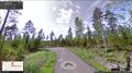
| − | Very close | + | Very close to hedgefence in the left at the address Risukarhikuja 8, 21420 Lieto [http://kansalaisen.karttapaikka.fi/linkki?scale=4000&text=Risukarhikuja+8%2C+21420+Lieto&srs=EPSG%3A3067&y=6717983&x=252102&lang=fi.] In the final frontier of the residential area of new family houses. |
| + | |||
| + | [[File:Turku 2016-01-16 60 22 Panorama.jpeg|800px]] | ||
Current Google street view [https://www.google.fi/maps/place/Risukarhikuja+8,+21420+Lieto/@60.5213477,22.4824489,3a,75y,282.93h,79.93t/data=!3m7!1e1!3m5!1socZohTHPQv2QFsPJKJ0WYg!2e0!6s%2F%2Fgeo1.ggpht.com%2Fcbk%3Fpanoid%3DocZohTHPQv2QFsPJKJ0WYg%26output%3Dthumbnail%26cb_client%3Dmaps_sv.tactile.gps%26thumb%3D2%26w%3D203%26h%3D100%26yaw%3D317.84943%26pitch%3D0!7i13312!8i6656!4m2!3m1!1s0x468c731a04908eb1:0x6f6d07f3b9db0ba] | Current Google street view [https://www.google.fi/maps/place/Risukarhikuja+8,+21420+Lieto/@60.5213477,22.4824489,3a,75y,282.93h,79.93t/data=!3m7!1e1!3m5!1socZohTHPQv2QFsPJKJ0WYg!2e0!6s%2F%2Fgeo1.ggpht.com%2Fcbk%3Fpanoid%3DocZohTHPQv2QFsPJKJ0WYg%26output%3Dthumbnail%26cb_client%3Dmaps_sv.tactile.gps%26thumb%3D2%26w%3D203%26h%3D100%26yaw%3D317.84943%26pitch%3D0!7i13312!8i6656!4m2!3m1!1s0x468c731a04908eb1:0x6f6d07f3b9db0ba] | ||
is from the August 2009 - time before the building of the houses. | is from the August 2009 - time before the building of the houses. | ||
| + | |||
| + | [[File:Turku_2016-01-16_60_22_GStreetview.jpeg|800px]] | ||
== Participants == | == Participants == | ||
| Line 33: | Line 37: | ||
== Plans == | == Plans == | ||
<!-- what were the original plans --> | <!-- what were the original plans --> | ||
| + | Checked friday evening what there is to do during the overnighter at Turku. | ||
| + | I'm not that much interested in geocaching nowadays so I checked also where the hashpoint was. | ||
| + | Luckily for me as I am bit lazy it seemed to be in the road. What more plans do you really need? | ||
== Expedition == | == Expedition == | ||
| Line 44: | Line 51: | ||
I could have reached the location without leaving my car, but I wanted to have better signal to my phone's GPS so I leaved the car. | I could have reached the location without leaving my car, but I wanted to have better signal to my phone's GPS so I leaved the car. | ||
| − | After some 10 or few more steps I was in the area according "Geohash droid" which I use - see the screenshot below. | + | After some 10 or few more steps I was in the area according "Geohash droid" which I use - see the screenshot below how far it was from the hotel. |
| Line 63: | Line 70: | ||
<gallery perrow="5"> | <gallery perrow="5"> | ||
| − | Image:2016-01-16_60_22_PPP_1452970359028.jpg|Done this - more to follow.... | + | Image:2016-01-16_60_22_PPP_1452970359028.jpg|Done this - more to follow. From my android @ the hotel... |
| + | |||
| + | Image:Turku 2016-01-16 60 22 GStreetview.jpeg| Before | ||
| + | |||
| + | Image:Turku 2016-01-16 60 22 Panorama.jpeg| After - Meet up | ||
| + | |||
</gallery> | </gallery> | ||
== Achievements == | == Achievements == | ||
{{#vardefine:ribbonwidth|800px}} | {{#vardefine:ribbonwidth|800px}} | ||
| − | |||
| − | |||
| − | |||
| − | |||
| − | |||
| − | |||
| − | |||
| − | |||
| − | |||
| − | |||
| − | |||
| − | |||
| − | |||
[[Category:Expeditions]] | [[Category:Expeditions]] | ||
| − | |||
[[Category:Expeditions with photos]] | [[Category:Expeditions with photos]] | ||
| − | |||
| − | |||
| − | |||
| − | |||
| − | |||
[[Category:Coordinates reached]] | [[Category:Coordinates reached]] | ||
| − | + | {{location|FI|19}} | |
| − | |||
| − | |||
| − | |||
| − | |||
| − | |||
| − | |||
| − | |||
| − | |||
| − | |||
| − | |||
| − | |||
| − | |||
| − | |||
| − | |||
| − | |||
| − | |||
| − | |||
Latest revision as of 06:30, 15 August 2019
| Sat 16 Jan 2016 in 60,22: 60.5212689, 22.4820224 geohashing.info google osm bing/os kml crox |
Location
Very close to hedgefence in the left at the address Risukarhikuja 8, 21420 Lieto [1] In the final frontier of the residential area of new family houses.

Current Google street view [2] is from the August 2009 - time before the building of the houses.

Participants
There was only me PPP (talk) 13:32, 16 January 2016 (EST) and the local male habitant from the Risukarhinkuja 6 whom I congratulated for archiving Couch Potato Geohash honorable mention and talked a while about geohashing.
Plans
Checked friday evening what there is to do during the overnighter at Turku. I'm not that much interested in geocaching nowadays so I checked also where the hashpoint was. Luckily for me as I am bit lazy it seemed to be in the road. What more plans do you really need?
Expedition
Left home around 10 at Helsinki. Highway 1 was in good winter condition - No snow but little icy in some places. We arrived to Turku around 13 o'clock after 181 km - Had to make a pitstop for fuel at the Salo.
After I left my significant other to hotel it was easy drive of 22 km to location was guided by my faithfull GPS. Although I have lived and worked in the past at Turku I cannot go anywhere without guidance.
I could have reached the location without leaving my car, but I wanted to have better signal to my phone's GPS so I leaved the car.
After some 10 or few more steps I was in the area according "Geohash droid" which I use - see the screenshot below how far it was from the hotel.

Weather was fine little cold, but no wind. EFTU 161120Z AUTO VRB01KT 9999 FEW047/// BKN059/// M12/M13 Q1012 R08/490195
Sun was shining momentarily and formed nice circle halos in the ice cristals. - No I didn't get any picture of those.
Tracklog
Photos
Done this - more to follow. From my android @ the hotel...
Before

After - Meet up