Difference between revisions of "2016-01-15 -36 175"
From Geohashing
imported>Jacksonz |
imported>Jacksonz m (Corrected Photo names) |
||
| Line 21: | Line 21: | ||
== Photos == | == Photos == | ||
<gallery perrow="4"> | <gallery perrow="4"> | ||
| − | File: | + | File:20160115 -36 175 GPS.jpg | GPS at the geohash |
| − | File: | + | File:20160115 -36 175 North.jpg | View to the North |
| − | File: | + | File:20160115 -36 175 East.jpg | View to the East |
| − | File: | + | File:20160115 -36 175 South.jpg | View to the South |
| − | File: | + | File:20160115 -36 175 West.jpg | View to the West |
| − | File: | + | File:20160115 -36 175 XKCD.jpg | The internet was here |
</gallery> | </gallery> | ||
Revision as of 11:06, 19 January 2016
| Fri 15 Jan 2016 in -36,175: -36.8838253, 175.0147260 geohashing.info google osm bing/os kml crox |
Contents
Location
Te Puru Park, Beachlands, Auckland
Participants
Plans
Noticed that today's Geohash was on the extreme western edge of the graticle, and realised that this would place the Coromandel Graticle within reasonable driving distance. It was a lovely summer's day, so took an extended lunch break to visit it.
Expedition
Left at midday in the hope of arriving at 1pm (4pm was not possible for me). As it happens, did not get to the geohash until 1:11pm. Took my photos in each direction and used a piece of chalk to mark the spot. Stayed about 30 minutes, before heading off to do a couple of nearby geocaches.
Photos
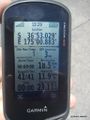
GPS at the geohash
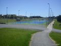
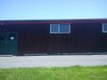
View to the North
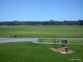
View to the East
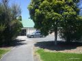
View to the South
View to the West
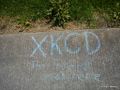
The internet was here


