Difference between revisions of "2016-01-21 52 1"
From Geohashing
imported>Sourcerer (→Planning) |
imported>Sourcerer m ([live picture] Arrival proof. [http://www.openstreetmap.org/?lat=52.40223706&lon=1.38464212&zoom=16&layers=B000FTF @52.4022,1.3846]) |
||
| Line 25: | Line 25: | ||
== Photos == | == Photos == | ||
<gallery perrow=4> | <gallery perrow=4> | ||
| + | |||
| + | Image:2016-01-21_52_1_Sourcerer_1453404377524.jpg | Arrival proof. [http://www.openstreetmap.org/?lat=52.40223706&lon=1.38464212&zoom=16&layers=B000FTF @52.4022,1.3846] | ||
</gallery> | </gallery> | ||
Revision as of 19:28, 21 January 2016
| Thu 21 Jan 2016 in Norwich, UK: 52.4022049, 1.3846535 geohashing.info google osm bing/os kml crox |
Location
A field south east of Saint Cross South Elmham, Suffolk, UK.
Participants
Plans
Expedition
Photos
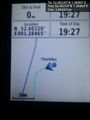
Arrival proof. @52.4022,1.3846

Achievements
Expeditions and Plans
| 2016-01-21 | ||
|---|---|---|
| Norwich, United Kingdom | Sourcerer | A field south east of Saint Cross South Elmham, Suffolk, UK. |
| Utrecht, Netherlands | JwB | A field in Flevoland |
| Närpiö, Finland | thestormer | A cow field in Närpes next to route 67. |
Sourcerer's Expedition Links
2016-01-16 52 1 - 2016-01-21 52 1 - 2016-01-22 52 1 - KML file download of Sourcerer's expeditions for use with Google Earth.