Difference between revisions of "2016-01-30 43 7"
From Geohashing
imported>Jiml (Expand Template) |
imported>FippeBot m (Location) |
||
| (4 intermediate revisions by 2 users not shown) | |||
| Line 1: | Line 1: | ||
| − | |||
| − | |||
| − | |||
| − | |||
<!-- If you did not specify these parameters in the template, please substitute appropriate values for IMAGE, LAT, LON, and DATE (YYYY-MM-DD format) | <!-- If you did not specify these parameters in the template, please substitute appropriate values for IMAGE, LAT, LON, and DATE (YYYY-MM-DD format) | ||
| Line 19: | Line 15: | ||
}} | }} | ||
| − | + | ||
__NOTOC__ | __NOTOC__ | ||
== Location == | == Location == | ||
| − | + | ||
| + | In the middle of a forest near Breil-sur-Roya (north-east of Nice). | ||
== Participants == | == Participants == | ||
| − | |||
| − | |||
| − | + | * [[User:Fractal|Fractal]] ([[User talk:Fractal|talk]]) | |
| − | + | * Monika | |
== Expedition == | == Expedition == | ||
| − | |||
| − | + | I ([[User:Fractal|Fractal]]) managed to convince Monika to go, by combining it with a hike on a nearby hiking trail. We had a very nice hike on the trail, and then we went to the hashpoint which was actually quite difficult to get to as it was in the middle of the forest and on a very non-horizontal ground, but we managed to reach it anyway \o/ | |
| − | |||
== Photos == | == Photos == | ||
| Line 42: | Line 35: | ||
Image:2012-##-## ## ## Alpha.jpg | Witty Comment | Image:2012-##-## ## ## Alpha.jpg | Witty Comment | ||
--> | --> | ||
| − | <gallery perrow="5"> | + | <gallery widths=200px heights=200px perrow="5"> |
| + | Image:2016-01-30 43 7-1.jpg | Us | ||
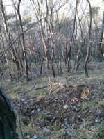
| + | Image:2016-01-30 43 7-2.jpg | The kind of terrain we had to go through | ||
| + | Image:2016-01-30 43 7-3.jpg | The hashpoint, maybe (I’m writing this expedition two years later) | ||
| + | Image:2016-01-30 43 7-4.jpg | The beautiful landscape that we could see during our hike | ||
| + | Image:2016-01-30 43 7-5.jpg | Surprised goats | ||
</gallery> | </gallery> | ||
| − | |||
| − | |||
| − | |||
| − | |||
| − | |||
| − | |||
| − | |||
| − | |||
| − | |||
| − | |||
| − | |||
| − | |||
| − | |||
| − | |||
| − | |||
| − | |||
| − | |||
| − | |||
[[Category:Expeditions]] | [[Category:Expeditions]] | ||
| − | |||
| − | |||
| − | |||
| − | |||
| − | |||
| − | |||
| − | |||
[[Category:Coordinates reached]] | [[Category:Coordinates reached]] | ||
| − | + | {{location|FR|06}} | |
| − | |||
| − | |||
| − | |||
| − | |||
| − | |||
| − | |||
| − | |||
| − | |||
| − | |||
| − | |||
| − | |||
| − | |||
| − | |||
| − | |||
| − | |||
| − | |||
| − | |||
Latest revision as of 01:35, 7 August 2019
| Sat 30 Jan 2016 in 43,7: 43.9269868, 7.5378281 geohashing.info google osm bing/os kml crox |
Location
In the middle of a forest near Breil-sur-Roya (north-east of Nice).
Participants
Expedition
I (Fractal) managed to convince Monika to go, by combining it with a hike on a nearby hiking trail. We had a very nice hike on the trail, and then we went to the hashpoint which was actually quite difficult to get to as it was in the middle of the forest and on a very non-horizontal ground, but we managed to reach it anyway \o/
Photos

Us

The kind of terrain we had to go through
The hashpoint, maybe (I’m writing this expedition two years later)

The beautiful landscape that we could see during our hike

Surprised goats


