Difference between revisions of "2016-01-31 49 8"
imported>Elimik31 (Created page with "{{subst:Expedition |lat = 49 |lon = 8 |date = 2016-01-31 }}") |
imported>FippeBot m (Location) |
||
| (4 intermediate revisions by one other user not shown) | |||
| Line 1: | Line 1: | ||
| − | |||
| − | |||
| − | |||
| − | |||
| − | |||
| − | |||
| − | |||
| − | |||
| − | |||
| − | |||
{{meetup graticule | {{meetup graticule | ||
| lat=49 | | lat=49 | ||
| Line 15: | Line 5: | ||
}} | }} | ||
| − | |||
__NOTOC__ | __NOTOC__ | ||
== Location == | == Location == | ||
| − | + | In a forest near Büchelberg, in Rheinland-Pfalz, West of the Rhine river, 17 km by air from Karlsruhe. | |
== Participants == | == Participants == | ||
| − | + | [[User:elimik31|elimik31]] | |
| − | |||
== Plans == | == Plans == | ||
| − | + | I had no plans, it was really spontaneous, but it seemed not that far away and I had already missed a nearby geohash the previous day. I was really tired today, but in the evening I felt a sudden urge to cycle and go on an adventure. In spite of the rain. Sometimes I am cruel to myself. | |
== Expedition == | == Expedition == | ||
| − | + | I was somewhere until 4 pm so I began cycling to the geohash when it was already late. I hadn't much of a plan, I just followed my Garmin, more or less. The actual distance that I cycled was much larger than the distance by air which was 17 km. That is due to the fact that I had to cross the Rhine river and there aren't many bridges. It was windy, raining a bit and after I crossed the Rhine river my Garmin let me through a lot of forest tracks, which shouldn't be much fun on a bicycle during rain. However, for some reason I don't understand, I had a lot of fun today, hadn't been geohashing in a while. At the hash location I had to walk 80 m through the deep forest with very little visibility. I waited a bit for my eyes adapt to the darkness, but it was quite scary, I imagined that I heard some boar noises. To the hash and back I cycled about 50 km. My phone batteries died, so no photos as proof, but even if I had it, it would have been to dark. I might upload a screenshot from my Garmin as a proof though. But first I need some hot tea and a shower. | |
| − | |||
| − | |||
| − | |||
== Photos == | == Photos == | ||
<!-- Insert pictures between the gallery tags using the following format: | <!-- Insert pictures between the gallery tags using the following format: | ||
| − | |||
--> | --> | ||
<gallery perrow="5"> | <gallery perrow="5"> | ||
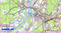
| + | Image:track_2016-01-31_49_8.png | My track | ||
</gallery> | </gallery> | ||
| − | |||
| − | |||
| − | |||
| − | |||
| − | |||
| − | |||
| − | |||
| − | |||
| − | |||
| − | |||
| − | |||
| − | |||
| − | |||
| − | |||
[[Category:Expeditions]] | [[Category:Expeditions]] | ||
| − | |||
| − | |||
| − | |||
| − | |||
| − | |||
| − | |||
| − | |||
[[Category:Coordinates reached]] | [[Category:Coordinates reached]] | ||
| − | + | {{location|DE|RP|GER}} | |
| − | |||
| − | |||
| − | |||
| − | |||
| − | |||
| − | |||
| − | |||
| − | |||
| − | |||
| − | |||
| − | |||
| − | |||
| − | |||
| − | |||
| − | |||
| − | |||
| − | |||
Latest revision as of 06:36, 15 August 2019
| Sun 31 Jan 2016 in 49,8: 49.0117833, 8.1763664 geohashing.info google osm bing/os kml crox |
Location
In a forest near Büchelberg, in Rheinland-Pfalz, West of the Rhine river, 17 km by air from Karlsruhe.
Participants
Plans
I had no plans, it was really spontaneous, but it seemed not that far away and I had already missed a nearby geohash the previous day. I was really tired today, but in the evening I felt a sudden urge to cycle and go on an adventure. In spite of the rain. Sometimes I am cruel to myself.
Expedition
I was somewhere until 4 pm so I began cycling to the geohash when it was already late. I hadn't much of a plan, I just followed my Garmin, more or less. The actual distance that I cycled was much larger than the distance by air which was 17 km. That is due to the fact that I had to cross the Rhine river and there aren't many bridges. It was windy, raining a bit and after I crossed the Rhine river my Garmin let me through a lot of forest tracks, which shouldn't be much fun on a bicycle during rain. However, for some reason I don't understand, I had a lot of fun today, hadn't been geohashing in a while. At the hash location I had to walk 80 m through the deep forest with very little visibility. I waited a bit for my eyes adapt to the darkness, but it was quite scary, I imagined that I heard some boar noises. To the hash and back I cycled about 50 km. My phone batteries died, so no photos as proof, but even if I had it, it would have been to dark. I might upload a screenshot from my Garmin as a proof though. But first I need some hot tea and a shower.
Photos
My track
