Difference between revisions of "2016-02-19 47 -122"
From Geohashing
imported>Zebburkeconte |
imported>FippeBot m (Location) |
||
| (4 intermediate revisions by 3 users not shown) | |||
| Line 1: | Line 1: | ||
| − | |||
| − | |||
| − | |||
| − | |||
| − | |||
| − | |||
| − | |||
| − | |||
| − | |||
{{meetup graticule | {{meetup graticule | ||
| lat=47 | | lat=47 | ||
| Line 15: | Line 6: | ||
}} | }} | ||
| − | + | ||
__NOTOC__ | __NOTOC__ | ||
| Line 22: | Line 13: | ||
== Participants == | == Participants == | ||
| − | [[User:Zebburkeconte|Zebburkeconte]] | + | *[[User:Zebburkeconte|Zebburkeconte]] |
| + | *[[User:benkaiser|benkaiser]] + Hayden + Joshua | ||
== Expedition == | == Expedition == | ||
| − | Not much to this one. Me and my dad drove over there. It was something like 20 minutes | + | Not much to this one. Me and my dad drove over there. It was something like 20 minutes drive. |
| + | |||
| + | [[User:benkaiser|benkaiser]] - Rounded up some friends and we also drove about 20 minutes (much later at night) to arrive at the hash. | ||
== Photos == | == Photos == | ||
| − | < | + | |
| − | Image: | + | <gallery perrow="5"> |
| − | --> | + | Image:2016-02-19_47_-122_1.jpg | The stupidest of Grins |
| + | Image:2016-02-19_47_-122_2.jpg | Proof | ||
| + | </gallery> | ||
| + | |||
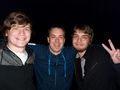
| + | [[User:benkaiser|benkaiser]] (and friends) | ||
| + | |||
<gallery perrow="5"> | <gallery perrow="5"> | ||
| + | Image:2016-02-19 47 -122 posers.jpg | The mates standing on the point | ||
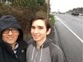
| + | Image:2016-02-19 47 -122 selfie.jpg | Selfie | ||
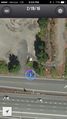
| + | Image:2016-02-19 47 -122 screenshot.png | Screenshot at the point | ||
</gallery> | </gallery> | ||
== Achievements == | == Achievements == | ||
{{#vardefine:ribbonwidth|800px}} | {{#vardefine:ribbonwidth|800px}} | ||
| − | |||
| − | + | {{land geohash | |
| − | + | | latitude = 47 | |
| − | + | | longitude = -122 | |
| − | + | | date = 2016-02-19 | |
| − | + | | name = zebburkeconte | |
| − | + | | image = | |
| − | + | }} | |
| − | |||
| − | |||
| − | |||
[[Category:Expeditions]] | [[Category:Expeditions]] | ||
| − | |||
[[Category:Expeditions with photos]] | [[Category:Expeditions with photos]] | ||
| − | |||
| − | |||
| − | |||
| − | |||
| − | |||
[[Category:Coordinates reached]] | [[Category:Coordinates reached]] | ||
| − | + | {{location|US|WA|KN}} | |
| − | |||
| − | |||
| − | |||
| − | |||
| − | |||
| − | |||
| − | |||
| − | |||
| − | |||
| − | |||
| − | |||
| − | |||
| − | |||
| − | |||
| − | |||
| − | |||
| − | |||
Latest revision as of 06:43, 15 August 2019
| Fri 19 Feb 2016 in 47,-122: 47.5802651, -122.1581315 geohashing.info google osm bing/os kml crox |
Location
On the shoulder of a road on the Eastside.
Participants
- Zebburkeconte
- benkaiser + Hayden + Joshua
Expedition
Not much to this one. Me and my dad drove over there. It was something like 20 minutes drive.
benkaiser - Rounded up some friends and we also drove about 20 minutes (much later at night) to arrive at the hash.
Photos
The stupidest of Grins
Proof


benkaiser (and friends)
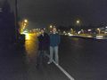
The mates standing on the point
Selfie
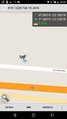
Screenshot at the point


Achievements
zebburkeconte earned the Land geohash achievement
|