Difference between revisions of "2016-03-23 49 8"
From Geohashing
imported>Q-Owl (Created page with "thumb|left|fenced area {{meetup graticule | lat=49 | lon=8 | date=2016-03-23 }}__NOTOC__ == Location == On a pasture near wikipedia:Groß...") |
imported>FippeBot m (Location) |
||
| (3 intermediate revisions by one other user not shown) | |||
| Line 7: | Line 7: | ||
== Location == | == Location == | ||
| − | On | + | On the [https://www.basf.com/en.html BASF] area near [[wikipedia:Frankenthal|Frankenthal]]. |
== Participants == | == Participants == | ||
| Line 15: | Line 15: | ||
== Plan == | == Plan == | ||
| − | Drive near the hashpoint, walk to it, take fotos and find a few geocaches. | + | Drive near the hashpoint, walk to it (if possible), take fotos and find a few geocaches. <br>On the satellite fotos seemed to be a chance to reach the hash point. |
== Expedition == | == Expedition == | ||
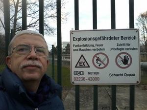
| − | + | I drove about 150 m next to the hash point and went near it. But there was a fence with barbed wire on top between me and the hp: Only 10 m distance. I took a GPS screenshot, a few fotos and left the place. | |
| − | + | ||
| − | + | About 1 km west from it I found a few geocaches. On the way back I stopped at IKEA's and bought big round crispbread, fischpaste and blueberry jam. :-) | |
== Photos == | == Photos == | ||
<gallery perrow="5" > | <gallery perrow="5" > | ||
| − | Image:2016-03-23 49 8 proof.png | | + | Image:2016-03-23 49 8 proof.png | 10 m off :-( |
| − | Image:2016-03-23 49 8 f1.jpg | Fenced . | + | Image:2016-03-23 49 8 f1.jpg | Fenced area |
| − | Image:2016-03-23 49 8 | + | Image:2016-03-23 49 8 night.jpg | BASF area at night |
| + | Image:2016-03-23 49 8 ikea.jpg | at IKEA's | ||
</gallery> | </gallery> | ||
<!-- | <!-- | ||
| Line 85: | Line 86: | ||
[[Category: Meetup on 2016-03-23]] | [[Category: Meetup on 2016-03-23]] | ||
[[Category: Meetup in 49 8]] | [[Category: Meetup in 49 8]] | ||
| + | {{location|DE|RP|FT}} | ||
Latest revision as of 06:58, 15 August 2019
| Wed 23 Mar 2016 in 49,8: 49.5465434, 8.4002527 geohashing.info google osm bing/os kml crox |
Location
On the BASF area near Frankenthal.
Participants
Plan
Drive near the hashpoint, walk to it (if possible), take fotos and find a few geocaches.
On the satellite fotos seemed to be a chance to reach the hash point.
Expedition
I drove about 150 m next to the hash point and went near it. But there was a fence with barbed wire on top between me and the hp: Only 10 m distance. I took a GPS screenshot, a few fotos and left the place.
About 1 km west from it I found a few geocaches. On the way back I stopped at IKEA's and bought big round crispbread, fischpaste and blueberry jam. :-)
Photos
Achievements / Honorable Mention
Q-Owl earned the Land geohash achievement
|
Q-Owl earned the No trespassing consolation prize
|
Other Geohashing Expeditions and Plans on this Day
Expeditions and Plans
| 2016-03-23 | ||
|---|---|---|
| Mannheim, Germany | Q-Owl | On the BASF area near Frankenthal. |
| Kassel, Germany | GeorgDerReisende | The hash lay in Hümme on the side of the former railway track of the Carlsb... |
| Norwich, United Kingdom | Sourcerer | A meadow close to the source of the river Chet, Norfolk, UK. |


