Difference between revisions of "2016-03-26 42 -85"
From Geohashing
imported>Mcbaneg (Created page with "<!-- If you did not specify these parameters in the template, please substitute appropriate values for IMAGE, LAT, LON, and DATE (YYYY-MM-DD format) {{{image|2016-03-26 42...") |
imported>Mcbaneg m (→Photos) |
||
| Line 39: | Line 39: | ||
Image:2016-03-26 42_-85_003.png | Proof. | Image:2016-03-26 42_-85_003.png | Proof. | ||
Image:2016-03-26 42_-85_008.jpg | Grins. | Image:2016-03-26 42_-85_008.jpg | Grins. | ||
| − | Image:2016-03-26 42_- | + | Image:2016-03-26 42_-85_007.jpg | Spruce tree. The satmap says the hashpoint is just to the right of the tree. |
</gallery> | </gallery> | ||
Revision as of 02:08, 27 March 2016
| Sat 26 Mar 2016 in 42,-85: 42.9628467, -85.5633580 geohashing.info google osm bing/os kml crox |
Location
Residential street, Forest Hills, MI
Participants
Expedition
Just a couple miles from home and good driving practice. This was a neighborhood of multifamily, single-story houses that looked very pleasant and well-kept. The house by the hashpoint had a lovely garden out front. The hashpoint appeared from the satmap to be a couple meters into the yard just east of a largish tree, but even on the sidewalk we were well within GPS error range. I made a quick step into the yard to get to our best guess of the true hashpoint but did not wait around for the GPS to settle.
Photos
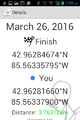
Proof.

Grins.
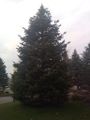
Spruce tree. The satmap says the hashpoint is just to the right of the tree.


