Difference between revisions of "2016-03-28 52 1"
From Geohashing
imported>ChromeCrusaders ([live picture]We did it [http://www.openstreetmap.org/?lat=52.79823160&lon=1.47689660&zoom=16&layers=B000FTF @52.7982,1.4769]) |
imported>ChromeCrusaders |
||
| Line 20: | Line 20: | ||
== Location == | == Location == | ||
<!-- where you've surveyed the hash to be --> | <!-- where you've surveyed the hash to be --> | ||
| − | + | A patch of Public Land very close to a patch of Private Land, East Ruston, Norwich | |
== Participants == | == Participants == | ||
<!-- who attended: If you link to your wiki user name in this section, your expedition will be picked up by the various statistics generated for geohashing. You may use three tildes ~ as a shortcut to automatically insert the user signature of the account you are editing with. | <!-- who attended: If you link to your wiki user name in this section, your expedition will be picked up by the various statistics generated for geohashing. You may use three tildes ~ as a shortcut to automatically insert the user signature of the account you are editing with. | ||
--> | --> | ||
| + | |||
| + | *[[User:ChromeCrusaders |ChromeCrusaders ]] | ||
== Plans == | == Plans == | ||
<!-- what were the original plans --> | <!-- what were the original plans --> | ||
| + | |||
| + | Spur of the moment idea as my friend and I found ourselfs bored. | ||
== Expedition == | == Expedition == | ||
| Line 35: | Line 39: | ||
-- [[User:ChromeCrusaders|ChromeCrusaders]] ([[User talk:ChromeCrusaders|talk]]) 16:43, 28 March 2016 (GMT+01:00) | -- [[User:ChromeCrusaders|ChromeCrusaders]] ([[User talk:ChromeCrusaders|talk]]) 16:43, 28 March 2016 (GMT+01:00) | ||
| − | + | ||
| − | + | *Arrived. | |
| + | |||
| + | -- [[User:ChromeCrusaders|ChromeCrusaders]] ([[User talk:ChromeCrusaders|talk]]) 18:02, 28 March 2016 (GMT+01:00) | ||
| + | |||
| + | Very easy drive by car, followed by about 20 steps of walking to reach the point. | ||
== Photos == | == Photos == | ||
<!-- Insert pictures between the gallery tags using the following format: | <!-- Insert pictures between the gallery tags using the following format: | ||
Image:2012-##-## ## ## Alpha.jpg | Witty Comment | Image:2012-##-## ## ## Alpha.jpg | Witty Comment | ||
| + | Image:521.jpeg | ||
--> | --> | ||
<gallery perrow="5"> | <gallery perrow="5"> | ||
Image:2016-03-28_52_1_ChromeCrusaders_1459184141594.jpg|We did it [http://www.openstreetmap.org/?lat=52.79823160&lon=1.47689660&zoom=16&layers=B000FTF @52.7982,1.4769] | Image:2016-03-28_52_1_ChromeCrusaders_1459184141594.jpg|We did it [http://www.openstreetmap.org/?lat=52.79823160&lon=1.47689660&zoom=16&layers=B000FTF @52.7982,1.4769] | ||
| + | Image:2016-03-28_52_1proof.jpeg | Proof. | ||
</gallery> | </gallery> | ||
| Line 50: | Line 60: | ||
{{#vardefine:ribbonwidth|800px}} | {{#vardefine:ribbonwidth|800px}} | ||
<!-- Add any achievement ribbons you earned below, or remove this section --> | <!-- Add any achievement ribbons you earned below, or remove this section --> | ||
| − | + | {{drag-along | |
| + | | latitude = 52 | ||
| + | | longitude = 1 | ||
| + | | date = 2016-03-28 | ||
| + | | partner = Joseph | ||
| + | | name = ChromeCrusaders | ||
| + | | image = Image:2012-##-## ## ## Alpha.jpg | ||
| + | }} | ||
<!-- =============== USEFUL CATEGORIES FOLLOW ================ | <!-- =============== USEFUL CATEGORIES FOLLOW ================ | ||
Delete the next line ONLY if you have chosen the appropriate categories below. If you are unsure, don't worry. People will read your report and help you with the classification. --> | Delete the next line ONLY if you have chosen the appropriate categories below. If you are unsure, don't worry. People will read your report and help you with the classification. --> | ||
[[Category:New report]] | [[Category:New report]] | ||
| − | |||
| − | |||
| − | |||
| − | |||
| − | |||
| − | |||
| − | |||
<!-- An actual expedition: | <!-- An actual expedition: | ||
[[Category:Expeditions]] | [[Category:Expeditions]] | ||
| − | |||
[[Category:Expeditions with photos]] | [[Category:Expeditions with photos]] | ||
| − | |||
[[Category:Expedition without GPS]] | [[Category:Expedition without GPS]] | ||
| − | |||
| − | |||
| − | |||
[[Category:Coordinates reached]] | [[Category:Coordinates reached]] | ||
| − | |||
| − | |||
| − | |||
| − | |||
| − | |||
| − | |||
| − | |||
| − | |||
| − | |||
| − | |||
| − | |||
| − | |||
| − | |||
| − | |||
| − | |||
| − | |||
| − | |||
| − | |||
Revision as of 19:49, 28 March 2016
| Mon 28 Mar 2016 in 52,1: 52.7981983, 1.4769133 geohashing.info google osm bing/os kml crox |
Location
A patch of Public Land very close to a patch of Private Land, East Ruston, Norwich
Participants
Plans
Spur of the moment idea as my friend and I found ourselfs bored.
Expedition
- On route
-- ChromeCrusaders (talk) 16:43, 28 March 2016 (GMT+01:00)
- Arrived.
-- ChromeCrusaders (talk) 18:02, 28 March 2016 (GMT+01:00)
Very easy drive by car, followed by about 20 steps of walking to reach the point.
Photos
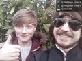
We did it @52.7982,1.4769
Proof.


Achievements
ChromeCrusaders earned the Drag-along achievement
|