Difference between revisions of "2016-03-29 62 22"
From Geohashing
imported>Thestormer (→Plans) |
imported>FippeBot m (Location) |
||
| (3 intermediate revisions by 2 users not shown) | |||
| Line 34: | Line 34: | ||
== Expedition == | == Expedition == | ||
<!-- how it all turned out. your narrative goes here. --> | <!-- how it all turned out. your narrative goes here. --> | ||
| + | The road here was ok, even if the last kilometer or so was a bit muddy and wet. We parked the car about 30 meters from ground zero, and luckily we didn't have to go too far out in the field, it was already getting quite muddy where the point was. We also saw the first bees of the year here, since there were beehives just on the other side of the road! | ||
== Tracklog == | == Tracklog == | ||
| Line 45: | Line 46: | ||
Image:2016-03-29_62_22_thestormer_1459253421339.jpg|A field near Koskenkorva [http://www.openstreetmap.org/?lat=62.67175140&lon=22.36797910&zoom=16&layers=B000FTF @62.6718,22.3680] | Image:2016-03-29_62_22_thestormer_1459253421339.jpg|A field near Koskenkorva [http://www.openstreetmap.org/?lat=62.67175140&lon=22.36797910&zoom=16&layers=B000FTF @62.6718,22.3680] | ||
| + | Image:2016-29-03-62-22-success.png | ||
| + | Image:2016-29-03-62-22-gps.jpg | ||
| + | Image:2016-29-03-62-22-beehives.jpg | ||
</gallery> | </gallery> | ||
== Achievements == | == Achievements == | ||
{{#vardefine:ribbonwidth|800px}} | {{#vardefine:ribbonwidth|800px}} | ||
| − | |||
| − | |||
| − | |||
| − | |||
| − | |||
| − | |||
| − | |||
| − | |||
| − | |||
| − | |||
| − | |||
| − | |||
| − | |||
[[Category:Expeditions]] | [[Category:Expeditions]] | ||
| − | |||
[[Category:Expeditions with photos]] | [[Category:Expeditions with photos]] | ||
| − | |||
| − | |||
| − | |||
| − | |||
| − | |||
[[Category:Coordinates reached]] | [[Category:Coordinates reached]] | ||
| − | + | {{location|FI|03}} | |
| − | |||
| − | |||
| − | |||
| − | |||
| − | |||
| − | |||
| − | |||
| − | |||
| − | |||
| − | |||
| − | |||
| − | |||
| − | |||
| − | |||
| − | |||
| − | |||
| − | |||
Latest revision as of 00:04, 16 August 2019
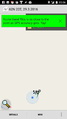
| Tue 29 Mar 2016 in 62,22: 62.6717039, 22.3680732 geohashing.info google osm bing/os kml crox |
Location
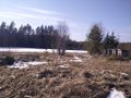
A field near Koskenkorva
Participants
Plans
Since we were going to Seinäjoki from Närpes today I checked if there would be a suitable geohash on the way, and yes indeed, there was. On a field near a road close to Koskenkorva there was a geohash that we easily could reach on the way, so I decided to put it on todays to-do list.
Expedition
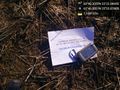
The road here was ok, even if the last kilometer or so was a bit muddy and wet. We parked the car about 30 meters from ground zero, and luckily we didn't have to go too far out in the field, it was already getting quite muddy where the point was. We also saw the first bees of the year here, since there were beehives just on the other side of the road!
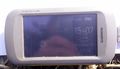
Tracklog
Photos
A field near Koskenkorva @62.6718,22.3680