Difference between revisions of "2016-04-10 49 8"
imported>DODO (→Expedition) |
imported>FippeBot m (Location) |
||
| (3 intermediate revisions by one other user not shown) | |||
| Line 40: | Line 40: | ||
== Tracklog == | == Tracklog == | ||
<!-- if your GPS device keeps a log, you may post a link here --> | <!-- if your GPS device keeps a log, you may post a link here --> | ||
| + | [https://www.komoot.de/tour/8511721 4 KM walking] I didn't track the car-drive. | ||
== Photos == | == Photos == | ||
| Line 45: | Line 46: | ||
Image:2012-##-## ## ## Alpha.jpg | Witty Comment | Image:2012-##-## ## ## Alpha.jpg | Witty Comment | ||
--> | --> | ||
| − | <gallery perrow=" | + | <gallery perrow="4"> |
| + | Image:2016-04-10_49_8-1.jpg|the parking area where I started... | ||
| + | Image:2016-04-10_49_8-2.jpg|... on this sunny way through the forest | ||
| + | Image:2016-04-10_49_8-7.png|To soon I reached the hash. | ||
| + | Image:2016-04-10_49_8-3.jpg|The view in three directions looks all the same | ||
| + | Image:2016-04-10_49_8-4.jpg|but in one direction (south) was the path | ||
| + | Image:2016-04-10_49_8-5.jpg|stupid grin | ||
| + | Image:2016-04-10_49_8-6.jpg|the new dune | ||
</gallery> | </gallery> | ||
| Line 51: | Line 59: | ||
{{#vardefine:ribbonwidth|800px}} | {{#vardefine:ribbonwidth|800px}} | ||
<!-- Add any achievement ribbons you earned below, or remove this section --> | <!-- Add any achievement ribbons you earned below, or remove this section --> | ||
| + | {{land geohash | ||
| + | | latitude = 49 | ||
| + | | longitude = 8 | ||
| + | | date = 2016-04-10 | ||
| + | | name = DODO | ||
| + | }} | ||
| − | |||
| − | |||
| − | |||
| − | |||
| − | |||
| − | |||
| − | |||
| − | |||
| − | |||
| − | |||
| − | |||
| − | |||
[[Category:Expeditions]] | [[Category:Expeditions]] | ||
| − | |||
[[Category:Expeditions with photos]] | [[Category:Expeditions with photos]] | ||
| − | |||
| − | |||
| − | |||
| − | |||
| − | |||
[[Category:Coordinates reached]] | [[Category:Coordinates reached]] | ||
| − | + | {{location|DE|BW|HD}} | |
| − | |||
| − | |||
| − | |||
| − | |||
| − | |||
| − | |||
| − | |||
| − | |||
| − | |||
| − | |||
| − | |||
| − | |||
| − | |||
| − | |||
| − | |||
| − | |||
| − | |||
Latest revision as of 00:10, 16 August 2019
| Sun 10 Apr 2016 in 49,8: 49.3151779, 8.6118037 geohashing.info google osm bing/os kml crox |
Location
Next to a path in the forest near Walldorf.
Participants
Plans
Expedition
Today was the official start of this years rowing season in my club and so I had to go rowing in the morning. I stayed there until a quarter past four. But the hash was so close to home that I had to go there. So I made a litte detour on my way home (in the end it was 13 kilometers more to drive, what matches perfectly with my fuel-policy). 2 kilometers from the hash was a parking area in the forest. Sun was shining, spring was everywhere and so it was a big pleasure to walk the way to the hash (although I was already tired from all the rowing today). I decided to make a little detour and got (a little) lost on my way back.
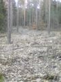
So I stumbled on a very sandy area, and a sign told me, that it was stubbed last year to build a dry grassland there. Those dunes had been quite familiar around here. They builded during the last ice age, but are pretty rare nowadays, partly because they were overgrown by the forest, mostly because they were used to win sand for building streets.
After 40 minutes and 4 kilometers walk I returned to my car and drove home.
Tracklog
4 KM walking I didn't track the car-drive.
Photos
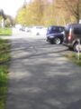
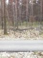
the parking area where I started...
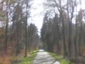
... on this sunny way through the forest
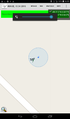
To soon I reached the hash.
The view in three directions looks all the same
but in one direction (south) was the path

stupid grin
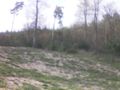
the new dune


Achievements
DODO earned the Land geohash achievement
|