Difference between revisions of "2016-04-17 52 1"
From Geohashing
imported>Sourcerer m (→Planning) |
imported>Sourcerer m (→New expedition) |
||
| Line 15: | Line 15: | ||
*[[User:Sourcerer|Sourcerer]] | *[[User:Sourcerer|Sourcerer]] | ||
| − | == Expedition == | + | == Expedition - Fail == |
| − | |||
| + | The hashpoint was in the paddock on the wrong side of a fence and the fast flowing stream. My closest approach was just before midnight. Just after midnight, I decided not to climb a gate and trespass. Expedition abandoned. | ||
== Photos == | == Photos == | ||
<gallery perrow="5"> | <gallery perrow="5"> | ||
| + | Image:2016-04-17 52 1 Sourcerer.jpg | Google Earth Track | ||
| + | Image:2016-04-17 52 1 Sourcerer Proof.jpg | Proof of Failure | ||
</gallery> | </gallery> | ||
| Line 34: | Line 36: | ||
}} | }} | ||
| − | |||
| − | |||
[[Category:Expeditions]] | [[Category:Expeditions]] | ||
[[Category:Expeditions with photos]] | [[Category:Expeditions with photos]] | ||
[[Category:Coordinates not reached]] | [[Category:Coordinates not reached]] | ||
| − | |||
Revision as of 23:27, 16 April 2016
| Sun 17 Apr 2016 in Norwich, UK: 52.3700107, 1.3712059 geohashing.info google osm bing/os kml crox |
Location
A stream-bed or paddock close to Metfield, Suffolk, UK,
Participants
Expedition - Fail
The hashpoint was in the paddock on the wrong side of a fence and the fast flowing stream. My closest approach was just before midnight. Just after midnight, I decided not to climb a gate and trespass. Expedition abandoned.
Photos
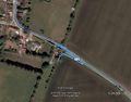
Google Earth Track
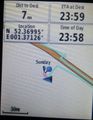
Proof of Failure


Achievements
Expeditions and Plans
| 2016-04-17 | ||
|---|---|---|
| Mannheim, Germany | DODO | A thicket near the community swimming pool in Schifferstadt. |
| Norwich, United Kingdom | Sourcerer | A stream-bed or paddock close to Metfield, Suffolk, UK, |
| Manchester, United Kingdom | Claire | 53.370°, 2.371° A field in Bowden |
Sourcerer's Expedition Links
2016-04-16 52 1 - 2016-04-17 52 1 - 2016-04-18 52 1 - KML file download of Sourcerer's expeditions for use with Google Earth.