Difference between revisions of "2016-04-28 49 10"
imported>Nicole1338 (→Tracklog) |
imported>FippeBot m (Location) |
||
| (9 intermediate revisions by 2 users not shown) | |||
| Line 47: | Line 47: | ||
{| | {| | ||
|- style="vertical-align:top;" | |- style="vertical-align:top;" | ||
| − | | style="width:300px;" | I forgot to track my route, so here is a picture of | + | | style="width:300px;" | I forgot to track my route, so here is a picture from the last part of my route and the detour because of the construction site. |
| [[Image:2016-04-28_49-10_Track.jpg |400px]] | | [[Image:2016-04-28_49-10_Track.jpg |400px]] | ||
|} | |} | ||
| Line 57: | Line 57: | ||
<gallery perrow="5"> | <gallery perrow="5"> | ||
| + | Image:2016-04-28_49-10_yay.png|yay[http://www.openstreetmap.org/?lat=49.54702860&lon=11.01949020&zoom=16&layers=B000FTF @49.5470,11.0195] | ||
Image:Arrived_web2.jpg|arrived[http://www.openstreetmap.org/?lat=49.54702860&lon=11.01949020&zoom=16&layers=B000FTF @49.5470,11.0195] | Image:Arrived_web2.jpg|arrived[http://www.openstreetmap.org/?lat=49.54702860&lon=11.01949020&zoom=16&layers=B000FTF @49.5470,11.0195] | ||
Image:2016-04-28_49-10_The_internet_was_here_web.jpg|The Internet was here[http://www.openstreetmap.org/?lat=49.54702860&lon=11.01949020&zoom=16&layers=B000FTF @49.5470,11.0195] | Image:2016-04-28_49-10_The_internet_was_here_web.jpg|The Internet was here[http://www.openstreetmap.org/?lat=49.54702860&lon=11.01949020&zoom=16&layers=B000FTF @49.5470,11.0195] | ||
| − | + | Image:2016-04-28_49-10_view_to_north.jpg|View to the north[http://www.openstreetmap.org/?lat=49.54702860&lon=11.01949020&zoom=16&layers=B000FTF @49.5470,11.0195] | |
| + | Image:2016-04-28_49-10_view_to_west.jpg|View to the west[http://www.openstreetmap.org/?lat=49.54702860&lon=11.01949020&zoom=16&layers=B000FTF @49.5470,11.0195] | ||
| + | Image:2016-04-28_49-10_view_to_south.jpg|View to the south[http://www.openstreetmap.org/?lat=49.54702860&lon=11.01949020&zoom=16&layers=B000FTF @49.5470,11.0195] | ||
| + | Image:2016-04-28_49-10_I_at_gz.jpg|I at ground zero[http://www.openstreetmap.org/?lat=49.54702860&lon=11.01949020&zoom=16&layers=B000FTF @49.5470,11.0195] | ||
</gallery> | </gallery> | ||
| Line 67: | Line 71: | ||
<!-- Add any achievement ribbons you earned below, or remove this section --> | <!-- Add any achievement ribbons you earned below, or remove this section --> | ||
| − | + | {{land geohash | |
| − | + | | latitude = 49 | |
| − | + | | longitude = 10 | |
| + | | date = 2016-04-28 | ||
| + | | name = Nicole1338 | ||
| + | | image = 2016-04-28_49-10_I_at_gz.jpg | ||
| + | | vehicle = car }} | ||
| − | |||
| − | |||
| − | |||
| − | |||
| − | |||
| − | |||
| − | |||
| − | |||
[[Category:Expeditions]] | [[Category:Expeditions]] | ||
| − | |||
[[Category:Expeditions with photos]] | [[Category:Expeditions with photos]] | ||
| − | |||
| − | |||
| − | |||
| − | |||
| − | |||
[[Category:Coordinates reached]] | [[Category:Coordinates reached]] | ||
| − | + | {{location|DE|BY|N}} | |
| − | |||
| − | |||
| − | |||
| − | |||
| − | |||
| − | |||
| − | |||
| − | |||
| − | |||
| − | |||
| − | |||
| − | |||
| − | |||
| − | |||
| − | |||
| − | |||
| − | |||
Latest revision as of 00:21, 16 August 2019
| Thu 28 Apr 2016 in 49,10: 49.5355529, 10.9962233 geohashing.info google osm bing/os kml crox |
Location
Meadow on a border to a privat property in Kleingründlach.
Participants
Plans
I was at work when I recognized that a geohash is not far away from me. Finally. I looked at the map and I decided to drive directly from work to the geohash. I know this area very well from geocaching, so I was in good spirits to find this place without problems.
Expedition
Finally, end of the work day. I was very excited to go to my first geohash point today. The weather was not bad, just a little bit cold and sometimes even the sun came out. I started from work and it was just about 3 km of driving away from me, but oh no.. there's a working site on the street which led to the hashpoint. Now I regret, that I haven't took the bike early today. After another 6 km and 10 minutes of driving I parked about 150 meter away from the point and I walked the remaining meters along the street. Shortly before the finish was a small ditch, the Kesselgraben. There were two possibilities to get around: Walk another 60 Meter to a small bridge or just jump over it. I decided for the second option. :) Another 10 meters of meadow between me and the point and finally I reached it!
I was very happy that I could finally made it to my first geohash today.
Tracklog
| I forgot to track my route, so here is a picture from the last part of my route and the detour because of the construction site. | 
|
Photos
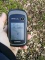
arrived@49.5470,11.0195
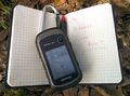
The Internet was here@49.5470,11.0195
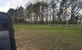
View to the north@49.5470,11.0195
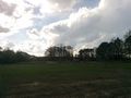
View to the west@49.5470,11.0195
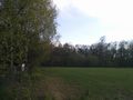
View to the south@49.5470,11.0195
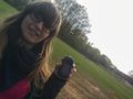
I at ground zero@49.5470,11.0195


Achievements
Nicole1338 earned the Land geohash achievement
|