Difference between revisions of "2016-04-29 47 19"
imported>Jiml m (Result codes look correct) |
imported>Nix78 (→Photos) |
||
| Line 33: | Line 33: | ||
<gallery perrow="5"> | <gallery perrow="5"> | ||
| − | Image:2016-04-29_47_19_Nix78_1461943222857.jpg|So, here I am on my first geohashing. No other hashers nearby, only a local who doesn't seem to understand why I'm standing on the edge of the field. I guess I'll complete this wiki later. :-) [http://www.openstreetmap.org/?lat=47.47430970&lon=19.30204780&zoom=16&layers=B000FTF @47.4743,19.3020] | + | Image:2016-04-29_47_19_Nix78_1461943222857.jpg|So, here I am on my first geohashing. No other hashers nearby, only a local who doesn't seem to understand why I'm standing on the edge of the field. I guess I'll complete this wiki later. :-) Sadly, no Tupid Grin, I was not prepared. :( [http://www.openstreetmap.org/?lat=47.47430970&lon=19.30204780&zoom=16&layers=B000FTF @47.4743,19.3020] |
Image:20160429_171213_HDR_.jpg | View from the field to the norhteast. | Image:20160429_171213_HDR_.jpg | View from the field to the norhteast. | ||
Image:20160429_171817_HDR_.jpg | The quiet suburb street. Looking southwest...ish. | Image:20160429_171817_HDR_.jpg | The quiet suburb street. Looking southwest...ish. | ||
Revision as of 08:13, 2 May 2016
| Fri 29 Apr 2016 in 47,19: 47.4743019, 19.3020541 geohashing.info google osm bing/os kml crox |
Location
At the edge of a field, on the end of a quiet suburb street. Your dream location for your first geohash.
Participants
Plans
A few days ago, years after I've first tried geohashing (which ended after a mere 3 days) I sort of incidentally reinstalled Geohash Droid (I was looking for something else in my history of ever installed apps). I was fiddling with may phone on the way home today and checked today's coordinates and I was surprised to see a not-so-far (12 or so kms) point. Not only was it close to where I live, it was on a field and looked like an example from Geohashing of Dummies: the get off the bus, walk a little and there you are type. THIS MUST BE A SIGN, I said to myself and so my epic journey has begun...
Expedition
As I expected,it was very easy: I traveled from Örs vezér tere to Kucorgó tér with bus 97E (during which I have read most of the wiki :) ) , walked all the way along a quiet suburb street, at the end, turned to the left, the the second street on the right and on the end of that street, there was this large tillage, where I quickly located the exact position (trying not stomping the seedlings). I took a few pictures, sent one of my first ever selfies here... and then... it was over. On my way back I took a few extra pictures of some fire hydrants, power substations, etc. (to put them to OSM later), I ate a celebratory ice cream and went home.
Photos

So, here I am on my first geohashing. No other hashers nearby, only a local who doesn't seem to understand why I'm standing on the edge of the field. I guess I'll complete this wiki later. :-) Sadly, no Tupid Grin, I was not prepared. :( @47.4743,19.3020
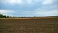
View from the field to the norhteast.
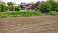
The quiet suburb street. Looking southwest...ish.
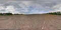
I even took a spherical panorama


Achievements
Nix78 earned the Land geohash achievement
|