Difference between revisions of "2016-04-29 47 19"
imported>Nix78 ([live picture]So, here I am on my first geohashing. No other hashers nearby, only a local who doesn't seem to understand why I'm standing on the edge of the field. I guess I'll complete this wiki later. :-) [http://www.openstreetmap.org/?lat=47.4743097...) |
imported>FippeBot m (Location) |
||
| (4 intermediate revisions by 3 users not shown) | |||
| Line 1: | Line 1: | ||
<!-- If you did not specify these parameters in the template, please substitute appropriate values for IMAGE, LAT, LON, and DATE (YYYY-MM-DD format) | <!-- If you did not specify these parameters in the template, please substitute appropriate values for IMAGE, LAT, LON, and DATE (YYYY-MM-DD format) | ||
| − | |||
| − | |||
| − | |||
| − | |||
| − | |||
And DON'T FORGET to add your expedition and the best photo you took to the gallery on the Main Page! We'd love to read your report, but that means we first have to discover it! :) | And DON'T FORGET to add your expedition and the best photo you took to the gallery on the Main Page! We'd love to read your report, but that means we first have to discover it! :) | ||
| Line 15: | Line 10: | ||
}} | }} | ||
| − | + | ||
__NOTOC__ | __NOTOC__ | ||
== Location == | == Location == | ||
| − | + | At the edge of a field, on the end of a quiet suburb street. Your dream location for your first geohash. | |
| + | |||
== Participants == | == Participants == | ||
| − | + | * [[User:Nix78|Nix78]] | |
| − | |||
== Plans == | == Plans == | ||
| − | + | ||
| + | A few days ago, years after I've first tried geohashing (which ended after a mere 3 days) I sort of incidentally reinstalled Geohash Droid (I was looking for something else in my history of ever installed apps). I was fiddling with may phone on the way home today and checked today's coordinates and I was surprised to see a not-so-far (12 or so kms) point. Not only was it close to where I live, it was on a field and looked like an example from Geohashing of Dummies: the get off the bus, walk a little and there you are type. THIS MUST BE A SIGN, I said to myself and so my epic journey has begun... | ||
== Expedition == | == Expedition == | ||
| − | + | As I expected,it was very easy: I traveled from Örs vezér tere to Kucorgó tér with bus 97E (during which I have read most of the wiki :) ) , walked all the way along a quiet suburb street, at the end, turned to the left, the the second street on the right and on the end of that street, there was this large tillage, where I quickly located the exact position (trying not stomping the seedlings). I took a few pictures, sent one of my first ever selfies here... and then... it was over. On my way back I took a few extra pictures of some fire hydrants, power substations, etc. (to put them to OSM later), I ate a celebratory ice cream and went home. | |
| + | |||
| − | |||
| − | |||
== Photos == | == Photos == | ||
| − | + | ||
| − | |||
| − | |||
<gallery perrow="5"> | <gallery perrow="5"> | ||
| − | Image:2016-04-29_47_19_Nix78_1461943222857.jpg|So, here I am on my first geohashing. No other hashers nearby, only a local who doesn't seem to understand why I'm standing on the edge of the field. I guess I'll complete this wiki later. :-) [http://www.openstreetmap.org/?lat=47.47430970&lon=19.30204780&zoom=16&layers=B000FTF @47.4743,19.3020] | + | Image:2016-04-29_47_19_Nix78_1461943222857.jpg|So, here I am on my first geohashing. No other hashers nearby, only a local who doesn't seem to understand why I'm standing on the edge of the field. I guess I'll complete this wiki later. :-) Sadly, no Tupid Grin, I was not prepared. :( [http://www.openstreetmap.org/?lat=47.47430970&lon=19.30204780&zoom=16&layers=B000FTF @47.4743,19.3020] |
| + | Image:20160429_171213_HDR_.jpg | View from the field to the norhteast. | ||
| + | Image:20160429_171817_HDR_.jpg | The quiet suburb street. Looking southwest...ish. | ||
| + | Image:2016-04-29_sp.jpg | I even took a spherical panorama | ||
</gallery> | </gallery> | ||
== Achievements == | == Achievements == | ||
{{#vardefine:ribbonwidth|800px}} | {{#vardefine:ribbonwidth|800px}} | ||
| − | |||
| − | + | {{land geohash | |
| − | + | | latitude = 47 | |
| − | + | | longitude = 19 | |
| − | + | | date = 2016-04-29 | |
| − | + | | name = Nix78 | |
| − | + | }} | |
| − | |||
| − | |||
| − | |||
| − | |||
[[Category:Expeditions]] | [[Category:Expeditions]] | ||
| − | |||
[[Category:Expeditions with photos]] | [[Category:Expeditions with photos]] | ||
| − | |||
| − | |||
| − | |||
| − | |||
| − | |||
[[Category:Coordinates reached]] | [[Category:Coordinates reached]] | ||
| − | + | {{location|HU|BU}} | |
| − | |||
| − | |||
| − | |||
| − | |||
| − | |||
| − | |||
| − | |||
| − | |||
| − | |||
| − | |||
| − | |||
| − | |||
| − | |||
| − | |||
| − | |||
| − | |||
| − | |||
Latest revision as of 00:22, 16 August 2019
| Fri 29 Apr 2016 in 47,19: 47.4743019, 19.3020541 geohashing.info google osm bing/os kml crox |
Location
At the edge of a field, on the end of a quiet suburb street. Your dream location for your first geohash.
Participants
Plans
A few days ago, years after I've first tried geohashing (which ended after a mere 3 days) I sort of incidentally reinstalled Geohash Droid (I was looking for something else in my history of ever installed apps). I was fiddling with may phone on the way home today and checked today's coordinates and I was surprised to see a not-so-far (12 or so kms) point. Not only was it close to where I live, it was on a field and looked like an example from Geohashing of Dummies: the get off the bus, walk a little and there you are type. THIS MUST BE A SIGN, I said to myself and so my epic journey has begun...
Expedition
As I expected,it was very easy: I traveled from Örs vezér tere to Kucorgó tér with bus 97E (during which I have read most of the wiki :) ) , walked all the way along a quiet suburb street, at the end, turned to the left, the the second street on the right and on the end of that street, there was this large tillage, where I quickly located the exact position (trying not stomping the seedlings). I took a few pictures, sent one of my first ever selfies here... and then... it was over. On my way back I took a few extra pictures of some fire hydrants, power substations, etc. (to put them to OSM later), I ate a celebratory ice cream and went home.
Photos

So, here I am on my first geohashing. No other hashers nearby, only a local who doesn't seem to understand why I'm standing on the edge of the field. I guess I'll complete this wiki later. :-) Sadly, no Tupid Grin, I was not prepared. :( @47.4743,19.3020
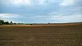
View from the field to the norhteast.
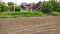
The quiet suburb street. Looking southwest...ish.
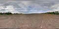
I even took a spherical panorama


Achievements
Nix78 earned the Land geohash achievement
|