Difference between revisions of "2016-04-27 42 -85"
imported>Mcbaneg |
imported>FippeBot m (Location) |
||
| (One intermediate revision by one other user not shown) | |||
| Line 30: | Line 30: | ||
It was in fact accessible. I was able to park nearby and walk along a grassy/brushy tractor road far enough from the adjoining houses that it didn't feel intrusive, and I saw no signs restricting access. The hashpoint was on a slope with a nice view of the airport. It's a pretty sleepy place: the only action I could see was a couple of deer running past a hangar. | It was in fact accessible. I was able to park nearby and walk along a grassy/brushy tractor road far enough from the adjoining houses that it didn't feel intrusive, and I saw no signs restricting access. The hashpoint was on a slope with a nice view of the airport. It's a pretty sleepy place: the only action I could see was a couple of deer running past a hangar. | ||
| − | I might have been more cautious had I read this | + | I might have been more cautious had I read this [http://woodtv.com/2015/01/19/police-plane-crashes-near-lowell-airport news article] ahead of time. Seems like this little airport has more excitement than it might like! |
| − | |||
| − | |||
| − | |||
| − | |||
== Photos == | == Photos == | ||
| Line 58: | Line 54: | ||
[[Category:Expeditions with photos]] | [[Category:Expeditions with photos]] | ||
[[Category:Coordinates reached]] | [[Category:Coordinates reached]] | ||
| + | {{location|US|MI|KN}} | ||
Latest revision as of 00:21, 16 August 2019
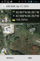
| Wed 27 Apr 2016 in 42,-85: 42.9574304, -85.3507117 geohashing.info google osm bing/os kml crox |
Location
Near the end of runway 12, Lowell City Airport, Lowell, MI
Participants
Expedition
This looked interesting: just under the glide path for the general-aviation Lowell City Airport. It wasn't clear whether I would be able to get access. I thought it was pretty likely I'd find "Airport-No Trespassing" signs. Nonetheless it was a nice evening and nobody was home when I came home from work so I left a note that said "Geohashing in Lowell. Home 8-830" and gave it a shot.
It was in fact accessible. I was able to park nearby and walk along a grassy/brushy tractor road far enough from the adjoining houses that it didn't feel intrusive, and I saw no signs restricting access. The hashpoint was on a slope with a nice view of the airport. It's a pretty sleepy place: the only action I could see was a couple of deer running past a hangar.
I might have been more cautious had I read this news article ahead of time. Seems like this little airport has more excitement than it might like!
Photos
Parking spot.
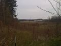
First view of airport during approach.
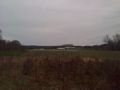
View SE toward airport from hashpoint.
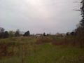
View W from hashpoint.
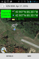
Proof.

Grin.
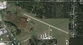
Satmap of airport. I'm not sure I want to live in that next-to-last house on Forstrom Drive SE.


