Difference between revisions of "2016-04-30 34 -117"
imported>AeroIllini ([live picture]Standing on the spot! Just a few hundred feet outside the fence line of Southern California Logistics Airport in Victorville. [http://www.openstreetmap.org/?lat=34.62325660&lon=-117.37955600&zoom=16&layers=B000FTF @34.6233,-117.3796]) |
imported>FippeBot m (Location) |
||
| (14 intermediate revisions by one other user not shown) | |||
| Line 20: | Line 20: | ||
== Location == | == Location == | ||
<!-- where you've surveyed the hash to be --> | <!-- where you've surveyed the hash to be --> | ||
| + | In the desert just to the east of the fence line of the Southern California Logistics Airport in Victorville, CA. | ||
== Participants == | == Participants == | ||
<!-- who attended: If you link to your wiki user name in this section, your expedition will be picked up by the various statistics generated for geohashing. You may use three tildes ~ as a shortcut to automatically insert the user signature of the account you are editing with. | <!-- who attended: If you link to your wiki user name in this section, your expedition will be picked up by the various statistics generated for geohashing. You may use three tildes ~ as a shortcut to automatically insert the user signature of the account you are editing with. | ||
--> | --> | ||
| + | * [[User:AeroIllini|AeroIllini]] | ||
== Plans == | == Plans == | ||
| Line 30: | Line 32: | ||
== Expedition == | == Expedition == | ||
<!-- how it all turned out. your narrative goes here. --> | <!-- how it all turned out. your narrative goes here. --> | ||
| + | [[User:AeroIllini|AeroIllini]], while visiting Victorville on a business trip from Seattle, stopped by the point in the early afternoon to snap a few photos. | ||
| + | |||
| + | Travel method was via rental car on roads around the airport that became increasingly less paved with proximity to the point, and then by foot in the last 1000 feet or so. | ||
| + | |||
| + | In the area, a line of tires was found, as well as a wooden structure, a fire pit shielded by a wall of tires, and some other evidence of human activity. | ||
| + | |||
| + | This was the first point in a Consecutive Hash Achievement. See [[2016-05-01 34 -117]] for the next expedition. | ||
== Tracklog == | == Tracklog == | ||
| Line 41: | Line 50: | ||
Image:2016-04-30_34_-117_AeroIllini_1462045990095.jpg|Standing on the spot! Just a few hundred feet outside the fence line of Southern California Logistics Airport in Victorville. [http://www.openstreetmap.org/?lat=34.62325660&lon=-117.37955600&zoom=16&layers=B000FTF @34.6233,-117.3796] | Image:2016-04-30_34_-117_AeroIllini_1462045990095.jpg|Standing on the spot! Just a few hundred feet outside the fence line of Southern California Logistics Airport in Victorville. [http://www.openstreetmap.org/?lat=34.62325660&lon=-117.37955600&zoom=16&layers=B000FTF @34.6233,-117.3796] | ||
| + | |||
| + | Image:2016-04-30_34_-117_AeroIllini_1462051646160.jpg|Found a curious line of tires out in the desert. | ||
| + | |||
| + | Image:2016-04-30_34_-117_AeroIllini_1462051696594.jpg|A tire-shielded fire pit. | ||
| + | |||
| + | Image:2016-04-30_34_-117_AeroIllini_1462051754274.jpg|Wooden structure | ||
| + | |||
| + | Image:2016-04-30_34_-117_AeroIllini_1462051807421.jpg|The road, leading toward KVCV airport. | ||
| + | |||
| + | Image:2016-04-30_34_-117_AeroIllini_1462051901731.jpg|A bridge over a trench. | ||
</gallery> | </gallery> | ||
| Line 47: | Line 66: | ||
<!-- Add any achievement ribbons you earned below, or remove this section --> | <!-- Add any achievement ribbons you earned below, or remove this section --> | ||
| − | + | {{consecutive geohash 2 | |
| − | |||
| − | |||
| − | + | | count = 2 | |
| − | + | | latitude = 34 | |
| − | + | | longitude = -117 | |
| − | -- | + | | date = 2016-04-30 |
| + | | name = AeroIllini | ||
| + | | image = 2016-05-01_34_-117_AeroIllini_1462113741138.jpg | ||
| − | + | }} | |
| − | |||
[[Category:Expeditions]] | [[Category:Expeditions]] | ||
| − | + | [[Category:Coordinates reached]] | |
[[Category:Expeditions with photos]] | [[Category:Expeditions with photos]] | ||
| − | + | {{location|US|CA|SA}} | |
| − | |||
| − | |||
| − | |||
| − | |||
| − | |||
| − | |||
| − | |||
| − | |||
| − | |||
| − | |||
| − | |||
| − | |||
| − | |||
| − | |||
| − | |||
| − | |||
| − | |||
| − | |||
| − | |||
| − | |||
| − | |||
| − | |||
| − | |||
Latest revision as of 00:23, 16 August 2019
| Sat 30 Apr 2016 in 34,-117: 34.6232513, -117.3795681 geohashing.info google osm bing/os kml crox |
Location
In the desert just to the east of the fence line of the Southern California Logistics Airport in Victorville, CA.
Participants
Plans
Expedition
AeroIllini, while visiting Victorville on a business trip from Seattle, stopped by the point in the early afternoon to snap a few photos.
Travel method was via rental car on roads around the airport that became increasingly less paved with proximity to the point, and then by foot in the last 1000 feet or so.
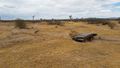
In the area, a line of tires was found, as well as a wooden structure, a fire pit shielded by a wall of tires, and some other evidence of human activity.
This was the first point in a Consecutive Hash Achievement. See 2016-05-01 34 -117 for the next expedition.
Tracklog
Photos
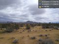
Standing on the spot! Just a few hundred feet outside the fence line of Southern California Logistics Airport in Victorville. @34.6233,-117.3796
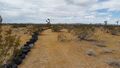
Found a curious line of tires out in the desert.
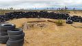
A tire-shielded fire pit.
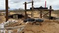
Wooden structure
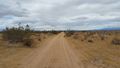
The road, leading toward KVCV airport.
A bridge over a trench.


Achievements
AeroIllini earned the Consecutive geohash achievement
|