Difference between revisions of "2016-05-04 39 -77"
From Geohashing
imported>Mckaysalisbury (adding basic achievements) |
imported>FippeBot m (Location) |
||
| (2 intermediate revisions by one other user not shown) | |||
| Line 39: | Line 39: | ||
== Achievements == | == Achievements == | ||
{{#vardefine:ribbonwidth|800px}} | {{#vardefine:ribbonwidth|800px}} | ||
| + | {{No_batteries_geohash | latitude = 39 | longitude = -77 | date = 2016-05-04 | name = [[User:Mckaysalisbury|McKay]] ([[User talk:Mckaysalisbury|talk]]) | image = 2016-05-04 39 -77 Crude.jpg}} | ||
| + | |||
[[Category:Expeditions]] | [[Category:Expeditions]] | ||
| Line 44: | Line 46: | ||
[[Category:Expedition without GPS]] | [[Category:Expedition without GPS]] | ||
[[Category:Coordinates reached]] | [[Category:Coordinates reached]] | ||
| + | {{location|US|VA|LD}} | ||
Latest revision as of 01:48, 7 August 2019

| Wed 4 May 2016 in 39,-77: 39.1440569, -77.6638713 geohashing.info google osm bing/os kml crox |
Location
On Rambling Farm Dr. Near Hamilton, VA
Participants
Plans
- 10:20 AM - Hmm, I think I'll head out there. 2 Hour drive for my first time in the graticule? I'll think about it over breakfast.
- 11:50 AM - I'm going. I'll be there in about an hour. I'm going to try for No Batteries Geohash. Should be easy enough with the poster, and a couple of notes on the back. McKay (talk) 15:52, 4 May 2016 (UTC)
Expedition
I took the poster, and drew a crude map on the back, and I left. I went up route 7, got off on the 704 to Colonial, then took that to Bettis, and that to Rambling Farm Dr. I looked around and found a few landmarks and took a spherical photo stitch.
Photos

The camera looking in the SW direction (with guy with stupid grin)

The camera looking in the SE direction (with guy with stupid grin)

The camera looking in the NW direction (with guy with stupid grin)
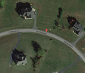
Google's image of the area
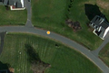
Bing's image of the area
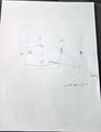
My crude map drawn on the back of the poster.


Achievements
McKay (talk) earned the No Batteries Geohash Achievement
|