Difference between revisions of "2008-05-29 47 -122"
From Geohashing
imported>Thomcat (Created Seattle visit page using new template.) |
imported>Thomcat (Added photos) |
||
| Line 16: | Line 16: | ||
Second geohash in a week, and 250 miles west of my last one. They were laying down gravel on a rural road, so I had to move the car. I stayed until just after 3pm, and I brought two games with me. | Second geohash in a week, and 250 miles west of my last one. They were laying down gravel on a rural road, so I had to move the car. I stayed until just after 3pm, and I brought two games with me. | ||
| − | + | <gallery> | |
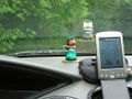
| + | Image:2008_05_29_47_-122_gps.jpg|GPS fix, in Pacific Standard Time | ||
| + | Image:2008_05_29_47_-122_truck.jpg|The truck moves up the road while I pull into a driveway. | ||
| + | Image:2008_05_29_47_-122.jpg|Thomcat makes his appearance. | ||
| + | </gallery> | ||
[[Category:Expeditions with photos]] | [[Category:Expeditions with photos]] | ||
[[Category:Expeditions]] | [[Category:Expeditions]] | ||
Revision as of 15:37, 30 May 2008
| Thu 29 May 2008 in 47,-122: 47.4647016, -122.0341244 geohashing.info google osm bing/os kml crox |
About
This hash is located south of Issaquah in the Seattle graticle. It is a rural road part way up Cedar Mountain.
Expeditions
Thomcat
Second geohash in a week, and 250 miles west of my last one. They were laying down gravel on a rural road, so I had to move the car. I stayed until just after 3pm, and I brought two games with me.
GPS fix, in Pacific Standard Time

The truck moves up the road while I pull into a driveway.

Thomcat makes his appearance.


