Difference between revisions of "2016-05-29 50 9"
imported>DODO (→Tracklog) |
imported>FippeBot m (Location) |
||
| (5 intermediate revisions by one other user not shown) | |||
| Line 29: | Line 29: | ||
== Plans == | == Plans == | ||
<!-- what were the original plans --> | <!-- what were the original plans --> | ||
| + | See [[2016-05-28_49_9]] | ||
== Expedition == | == Expedition == | ||
<!-- how it all turned out. your narrative goes here. --> | <!-- how it all turned out. your narrative goes here. --> | ||
| − | + | Even during my excellent meal yesterday it was raining all the time and it continued raining all night long. Furthermore the ladies announced an early return, my feet were aching, and breakfast started not before eight on sunday, so I won't start early.I really considered to walk to the station in Heigenbrücken and just ride home. Even more as the breakfast was as good as the dinner, and it got later and later. And the hash won't probably be reachable anyway. But when I started finally at 9:30 the rain came to a sudden stop and the fog rising from the hills around was looking so beautiful that I couldn't resist (I luckily didn't mention that the forest and the paths and the grass and everything would be very wet after all the rain). | |
| + | |||
| + | Anyway, I walked again. First I followed the valley for half an hour but soon I had to climb the next mountain again (it seems to be characteristic for the Spessart to let the paths follow the slope line - so they are shortest). But when I was back on the height again - wet not only from gras and wood but mostly from my own sweat - the path was beautiful and the forest was lighter and looked more friendly than yesterday. Again and again it was interrupted by some fields and even some villages came in view. | ||
| + | |||
| + | After a long time of walking I reached a place called Eidengesäß (oath bottom). From here it wasn't far to the hash anymore and the forest changed to some open fields and grasslands. After a while I reached the tennis club. Access was really easy although two people were playing tennis at the court but didn't get bothered by me. I hoped for some drink at the tennis club but nobody else was there. So I walked to the terrace of the club house where the hast was located, but under the roof gps-reception was really bad and I didn't wan't to dance around to much for not getting to much attention fron the players. So I just got a miserable proof, but you see the terrace at the pictures. By the way, this seems to be the area with the most funny village names in Germany. The village the club belongs to is called Linsengericht (lentil dish). | ||
| + | |||
| + | After some photos I continued my way to the station in Gelnhausen what was just two more kilometers to go. When I came near the station I see a train leave. Two minutes earlier ... At the station I realized that that train was twenty minutes late and I just had 40 minutes to wait. An ideal occasion to celebrate my success (especially the completed minesweeper achievement) with some ice-cream. | ||
== Tracklog == | == Tracklog == | ||
| Line 43: | Line 50: | ||
--> | --> | ||
<gallery perrow="5"> | <gallery perrow="5"> | ||
| + | Image:2016-05-29_50_9-00.jpg|for, forest and lake | ||
| + | Image:2016-05-29_50_9-01.jpg|bridge? | ||
| + | Image:2016-05-29_50_9-02.jpg|nice | ||
| + | Image:2016-05-29_50_9-03.jpg|impressive | ||
| + | Image:2016-05-29_50_9-04.jpg|church and ... | ||
| + | Image:2016-05-29_50_9-05.jpg|...fire brigae of Eidengesäß | ||
| + | Image:2016-05-29_50_9-06.jpg|view to the hash | ||
| + | Image:2016-05-29_50_9-12.png|kind of proof | ||
| + | Image:2016-05-29_50_9-07.jpg|and the happy hasher | ||
| + | Image:2016-05-29_50_9-08.jpg|some people playing hash-tennis | ||
| + | Image:2016-05-29_50_9-09.jpg|Linsengericht (and there are villages connected to) | ||
| + | Image:2016-05-29_50_9-11.jpg|celebration | ||
</gallery> | </gallery> | ||
| Line 49: | Line 68: | ||
<!-- Add any achievement ribbons you earned below, or remove this section --> | <!-- Add any achievement ribbons you earned below, or remove this section --> | ||
| − | + | {{land geohash | |
| − | + | | latitude = 50 | |
| − | + | | longitude = 9 | |
| + | | date = 2016-05-29 | ||
| + | | name = DODO | ||
| + | }} | ||
| − | + | {{consecutive geohash | |
| − | + | | count = 2 | |
| − | [[ | + | | latitude = 49 |
| − | -- | + | | longitude = 9 |
| + | | date = 2016-05-28 | ||
| + | | name = [[User:DODO|DODO]] | ||
| + | }} | ||
| + | |||
| + | {{Walk geohash | ||
| + | | latitude = 50 | ||
| + | | longitude = 9 | ||
| + | | date = 2016-05-29 | ||
| + | | name = DODO | ||
| + | | distance = 32 KM | ||
| + | }} | ||
| − | + | {{Minesweeper geohash | |
| + | | graticule = Mannheim, Germany | ||
| + | | ranknumber = 8 | ||
| + | | nw = true | ||
| + | | w = true | ||
| + | | sw = true | ||
| + | | n = true | ||
| + | | s = true | ||
| + | | ne = true | ||
| + | | e = true | ||
| + | | se=true | ||
| + | | name = DODO | ||
| + | }} | ||
| − | |||
[[Category:Expeditions]] | [[Category:Expeditions]] | ||
| − | |||
| − | |||
| − | |||
| − | |||
| − | |||
| − | |||
| − | |||
[[Category:Coordinates reached]] | [[Category:Coordinates reached]] | ||
| − | + | {{location|DE|HE|MKK}} | |
| − | |||
| − | |||
| − | |||
| − | |||
| − | |||
| − | |||
| − | |||
| − | |||
| − | |||
| − | |||
| − | |||
| − | |||
| − | |||
| − | |||
| − | |||
| − | |||
| − | |||
Latest revision as of 01:51, 7 August 2019
| Sun 29 May 2016 in 50,9: 50.1879472, 9.2120262 geohashing.info google osm bing/os kml crox |
Location
At the tennis club in Linsengericht (what really means lentil dish).
Participants
Plans
See 2016-05-28_49_9
Expedition
Even during my excellent meal yesterday it was raining all the time and it continued raining all night long. Furthermore the ladies announced an early return, my feet were aching, and breakfast started not before eight on sunday, so I won't start early.I really considered to walk to the station in Heigenbrücken and just ride home. Even more as the breakfast was as good as the dinner, and it got later and later. And the hash won't probably be reachable anyway. But when I started finally at 9:30 the rain came to a sudden stop and the fog rising from the hills around was looking so beautiful that I couldn't resist (I luckily didn't mention that the forest and the paths and the grass and everything would be very wet after all the rain).
Anyway, I walked again. First I followed the valley for half an hour but soon I had to climb the next mountain again (it seems to be characteristic for the Spessart to let the paths follow the slope line - so they are shortest). But when I was back on the height again - wet not only from gras and wood but mostly from my own sweat - the path was beautiful and the forest was lighter and looked more friendly than yesterday. Again and again it was interrupted by some fields and even some villages came in view.
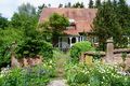
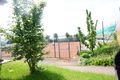
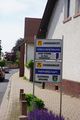
After a long time of walking I reached a place called Eidengesäß (oath bottom). From here it wasn't far to the hash anymore and the forest changed to some open fields and grasslands. After a while I reached the tennis club. Access was really easy although two people were playing tennis at the court but didn't get bothered by me. I hoped for some drink at the tennis club but nobody else was there. So I walked to the terrace of the club house where the hast was located, but under the roof gps-reception was really bad and I didn't wan't to dance around to much for not getting to much attention fron the players. So I just got a miserable proof, but you see the terrace at the pictures. By the way, this seems to be the area with the most funny village names in Germany. The village the club belongs to is called Linsengericht (lentil dish).
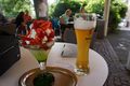
After some photos I continued my way to the station in Gelnhausen what was just two more kilometers to go. When I came near the station I see a train leave. Two minutes earlier ... At the station I realized that that train was twenty minutes late and I just had 40 minutes to wait. An ideal occasion to celebrate my success (especially the completed minesweeper achievement) with some ice-cream.
Tracklog
Photos
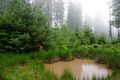
for, forest and lake
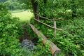
bridge?
nice
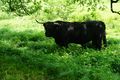
impressive
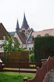
church and ...
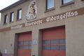
...fire brigae of Eidengesäß
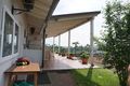
view to the hash
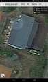
kind of proof

and the happy hasher
some people playing hash-tennis
Linsengericht (and there are villages connected to)
celebration


Achievements
DODO earned the Land geohash achievement
|
DODO earned the Consecutive geohash achievement
|
DODO earned the Walk geohash Achievement
|
DODO completed the Minesweeper Geohash achievement
|