Difference between revisions of "2016-05-30 43 -85"
imported>Mcbaneg (Created page with "<!-- If you did not specify these parameters in the template, please substitute appropriate values for IMAGE, LAT, LON, and DATE (YYYY-MM-DD format) {{{image|dummy.jpg}}}|...") |
imported>FippeBot m (Location) |
||
| (2 intermediate revisions by one other user not shown) | |||
| Line 8: | Line 8: | ||
And DON'T FORGET to add your expedition and the best photo you took to the gallery on the Main Page! We'd love to read your report, but that means we first have to discover it! :) | And DON'T FORGET to add your expedition and the best photo you took to the gallery on the Main Page! We'd love to read your report, but that means we first have to discover it! :) | ||
--> | --> | ||
| − | + | ||
{{meetup graticule | {{meetup graticule | ||
| Line 28: | Line 28: | ||
== Expedition == | == Expedition == | ||
| − | Beautiful Memorial Day expedition. It looked like most of the approach could be made along a power line right of way. | + | Beautiful Memorial Day expedition. It looked like most of the approach could be made along a power line right of way. Sometimes those are passable, sometimes not. In this case we lucked out. The power company is in the process of replacing a wooden pylon with metal ones, and their installation vehicle had mowed a lovely, easy-to-walk road along the right of way to within about 60 m of the hashpoint. When we arrived at the point where the grassy section and the new road ended, we faced an impenetrable-looking sassafras thicket. But at that point we went south into the open and navigable forest and were able to reach the hashpoint pretty easily. |
<!-- Insert pictures between the gallery tags using the following format: | <!-- Insert pictures between the gallery tags using the following format: | ||
| Line 51: | Line 51: | ||
[[Category:Expeditions with photos]] | [[Category:Expeditions with photos]] | ||
[[Category:Coordinates reached]] | [[Category:Coordinates reached]] | ||
| + | {{location|US|MI|KN}} | ||
Latest revision as of 00:40, 16 August 2019
| Mon 30 May 2016 in 43,-85: 43.1077141, -85.5989759 geohashing.info google osm bing/os kml crox |
Location
Hardwood forest near Belmont Ave, Plainfield, MI
Participants
Expedition
Beautiful Memorial Day expedition. It looked like most of the approach could be made along a power line right of way. Sometimes those are passable, sometimes not. In this case we lucked out. The power company is in the process of replacing a wooden pylon with metal ones, and their installation vehicle had mowed a lovely, easy-to-walk road along the right of way to within about 60 m of the hashpoint. When we arrived at the point where the grassy section and the new road ended, we faced an impenetrable-looking sassafras thicket. But at that point we went south into the open and navigable forest and were able to reach the hashpoint pretty easily.
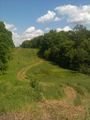
Lucky break: road toward hashpoint..
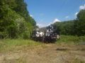
The power company's pole-planting machine.
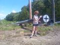
The finest Phillips screw I've ever seen.
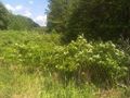
Sassafras thicket, encouraging us to choose a different route from here.
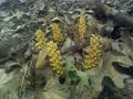
Anybody know what this is?
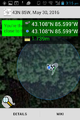
Proof.

Grins.


