Difference between revisions of "2016-06-01 49 8"
imported>DODO (→Participants) |
imported>FippeBot m (Location) |
||
| (7 intermediate revisions by one other user not shown) | |||
| Line 29: | Line 29: | ||
== Plans == | == Plans == | ||
<!-- what were the original plans --> | <!-- what were the original plans --> | ||
| + | To go there after work and expand my ride home to a nice tron-loop. | ||
== Expedition == | == Expedition == | ||
<!-- how it all turned out. your narrative goes here. --> | <!-- how it all turned out. your narrative goes here. --> | ||
| + | I left the office at a quarter to five and had a quite uneventful ride through the southern districts of Mannheim.But when I came close to the hash I took a wrong turn To early and then the road that I wanted to take to fix my mistake was blocked. So I had to turn back and the tron was lost. Nevertheless, I reached the hashpoint some minutes later - or what I thought it would be the hashpoint. Hashdriod had a slightly different opinion. Well, that's not all true. He located the cashpoint exactly where I stood, but first he saw me on the opposite side of the broad road, 34 m away, and after I had taken some pictures, he was sure, I was inside the house, still 12m of the point. | ||
| + | |||
| + | Well, I think the pictures proof that I wasn't inside the house and I can claim this as a success. | ||
| + | |||
| + | Unfortunately I have a lot of work to do at the moment and so I don't have the time to edit the pictures for this tour (or for the much more urgent ones [[2016-05-28_49_9]] or [[2016-05-29_50_9]]). Could have done instead of going hashing but I set wrong priorities :-( | ||
== Tracklog == | == Tracklog == | ||
<!-- if your GPS device keeps a log, you may post a link here --> | <!-- if your GPS device keeps a log, you may post a link here --> | ||
| + | [https://www.komoot.de/tour/9538309 52 KM by bull] | ||
== Photos == | == Photos == | ||
| Line 40: | Line 47: | ||
Image:2012-##-## ## ## Alpha.jpg | Witty Comment | Image:2012-##-## ## ## Alpha.jpg | Witty Comment | ||
--> | --> | ||
| − | <gallery perrow=" | + | <gallery perrow="4"> |
| + | Image:2016-06-01_49_8-1.jpg|I came along [[2015-09-09 49 8]] | ||
| + | Image:2016-06-01_49_8-2.jpg|proof of transport | ||
| + | Image:2016-06-01_49_8-3.jpg|view from the hash westwards | ||
| + | Image:2016-06-01_49_8-4.jpg|to the south | ||
| + | Image:2016-06-01_49_8-5.jpg|to the hasher | ||
| + | Image:2016-06-01_49_8-6.jpg|and the southeast | ||
| + | Image:2016-06-01_49_8-7.png|of course I wasn't inside the house but in front of it | ||
</gallery> | </gallery> | ||
| Line 47: | Line 61: | ||
<!-- Add any achievement ribbons you earned below, or remove this section --> | <!-- Add any achievement ribbons you earned below, or remove this section --> | ||
| − | + | {{land geohash | |
| − | + | | latitude = 49 | |
| − | + | | longitude = 8 | |
| − | + | | date = 2016-06-01 | |
| − | + | | name = DODO | |
| − | + | }} | |
| − | |||
| − | |||
| − | |||
| − | |||
| − | |||
[[Category:Expeditions]] | [[Category:Expeditions]] | ||
| − | |||
| − | |||
| − | |||
| − | |||
| − | |||
| − | |||
| − | |||
[[Category:Coordinates reached]] | [[Category:Coordinates reached]] | ||
| − | + | {{location|DE|BW|MA}} | |
| − | |||
| − | |||
| − | |||
| − | |||
| − | |||
| − | |||
| − | |||
| − | |||
| − | |||
| − | |||
| − | |||
| − | |||
| − | |||
| − | |||
| − | |||
| − | |||
| − | |||
Latest revision as of 00:40, 16 August 2019
| Wed 1 Jun 2016 in 49,8: 49.4777521, 8.5068011 geohashing.info google osm bing/os kml crox |
Location
On the pavement of a road in Mannheim-Neuostheim.
Participants
Plans
To go there after work and expand my ride home to a nice tron-loop.
Expedition
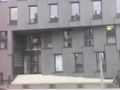
I left the office at a quarter to five and had a quite uneventful ride through the southern districts of Mannheim.But when I came close to the hash I took a wrong turn To early and then the road that I wanted to take to fix my mistake was blocked. So I had to turn back and the tron was lost. Nevertheless, I reached the hashpoint some minutes later - or what I thought it would be the hashpoint. Hashdriod had a slightly different opinion. Well, that's not all true. He located the cashpoint exactly where I stood, but first he saw me on the opposite side of the broad road, 34 m away, and after I had taken some pictures, he was sure, I was inside the house, still 12m of the point.
Well, I think the pictures proof that I wasn't inside the house and I can claim this as a success.
Unfortunately I have a lot of work to do at the moment and so I don't have the time to edit the pictures for this tour (or for the much more urgent ones 2016-05-28_49_9 or 2016-05-29_50_9). Could have done instead of going hashing but I set wrong priorities :-(
Tracklog
Photos
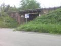
I came along 2015-09-09 49 8
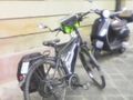
proof of transport
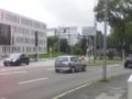
view from the hash westwards
to the south

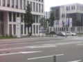
to the hasher
and the southeast
of course I wasn't inside the house but in front of it


Achievements
DODO earned the Land geohash achievement
|