Difference between revisions of "2016-06-01 52 1"
From Geohashing
imported>Sourcerer (→New expedition) |
imported>Sourcerer m (→Photos) |
||
| Line 23: | Line 23: | ||
<gallery perrow="5"> | <gallery perrow="5"> | ||
Image:2016-06-01 52 1 Sourcerer.jpg | Failure to reach the point. | Image:2016-06-01 52 1 Sourcerer.jpg | Failure to reach the point. | ||
| + | Image:2016-06-01 52 1 Sourcerer Fail.jpg | 150 metres to go. | ||
</gallery> | </gallery> | ||
Revision as of 22:05, 2 June 2016
| Wed 1 Jun 2016 in Norwich, UK: 52.4777521, 1.5068011 geohashing.info google osm bing/os kml crox |
Location
A sugar beet field near Geldeston, Norfolk, UK.
Participants
Expedition - Fail
The hashpoint was 140 metres from the road. The sugar beet was growing well. Access without damage might have been possible but it was border line. I decided not to proceed.
Photos
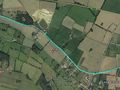
Failure to reach the point.
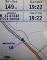
150 metres to go.


Achievements
Expeditions and Plans
| 2016-06-01 | ||
|---|---|---|
| Mannheim, Germany | DODO | On the pavement of a road in Mannheim-Neuostheim. |
| Norwich, United Kingdom | Sourcerer | A sugar beet field near Geldeston, Norfolk, UK. |
| Utrecht, Netherlands | JwB | Between bikepath and motorway on Larserweg, near Lelystad |
| Malmö, Sweden | Fasanen | Södra Kungsgatan 9, Skurup, Sweden |
Sourcerer's Expedition Links
2016-05-31 52 -3 - 2016-06-01 52 1 - 2016-06-02 52 1 - KML file download of Sourcerer's expeditions for use with Google Earth.