Difference between revisions of "2016-06-19 60 28"
imported>Tilley (What is Tilley doing in Lappeenranta?) |
imported>FippeBot m (Location) |
||
| (3 intermediate revisions by one other user not shown) | |||
| Line 13: | Line 13: | ||
== Expedition == | == Expedition == | ||
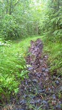
[[File:2016-06-19_60_28_WP_20160619_10_10_04_Pro_1500px.jpg|200px|thumb|left|The "road".]] | [[File:2016-06-19_60_28_WP_20160619_10_10_04_Pro_1500px.jpg|200px|thumb|left|The "road".]] | ||
| − | This weekend in Lappeenranta there was the largest annual orienteering competition in Finland, the [http://www.jukola.com/2016/en/ Jukola relay]. Just the day before, I had been drafted into a team participating the relay as a substitute for a person who had gotten sick. So, after almost sleepless night and starting at 4:45 am and orienteering 14,1 km in 3 hours and 10 minutes in a challenging weather and terrain and being able to lift my team from position 1574 to 1546 during my leg, I wondered what to do. Well, I was still wearing orienteering clothes and the hashpoint of the current graticule was only a few kilometers away, hmm, that is a tough one... | + | This weekend in Lappeenranta there was the largest annual orienteering competition in Finland with 17500 participants, the [http://www.jukola.com/2016/en/ Jukola relay]. Just the day before, I had been drafted into a team participating the relay as a substitute for a person who had gotten sick. So, after almost sleepless night and starting at 4:45 am and orienteering 14,1 km in 3 hours and 10 minutes in a challenging weather and terrain and being able to lift my team from position 1574 to 1546 during my leg, I wondered what to do. Well, I was still wearing orienteering clothes and the hashpoint of the current graticule was only a few kilometers away, hmm, that is a tough one... |
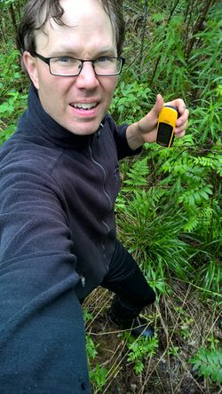
[[File:2016-06-19_60_28_WP_20160619_10_15_17_Pro_1500px.jpg|250px|thumb|right|The pose on the hashpoint.]] | [[File:2016-06-19_60_28_WP_20160619_10_15_17_Pro_1500px.jpg|250px|thumb|right|The pose on the hashpoint.]] | ||
| Line 21: | Line 21: | ||
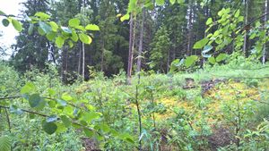
[[File:2016-06-19_60_28_WP_20160619_10_15_34_Pro_1500px.jpg|300px|thumb|left|A view from the hashpoint towards the clearing.]] | [[File:2016-06-19_60_28_WP_20160619_10_15_34_Pro_1500px.jpg|300px|thumb|left|A view from the hashpoint towards the clearing.]] | ||
| − | Finding my way towards the point with a gps device and the map from a smartphone felt odd after spending whole morning orienteering with more traditional equipment. I actually really missed compass! It is a good device to instantly tell which direction a trail goes. The hashpoint was nevertheless reached, and my clothes didn't even get any more wet than they already were (because they were soaked already)! The point reminded me of some of the checkpoints of the race: a wet and dense thicket near a forest clearing. I took some pictures and walked back to the car. Then I drove home, exhausted but happy. Too bad the point wasn't on the actual competition | + | Finding my way towards the point with a gps device and the map from a smartphone felt odd after spending whole morning orienteering with more traditional equipment. I actually really missed compass! It is a good device to instantly tell which direction a trail goes. The hashpoint was nevertheless reached, and my clothes didn't even get any more wet than they already were (because they were soaked already)! The point reminded me of some of the checkpoints of the race: a wet and dense thicket near a forest clearing. I took some pictures and walked back to the car. Then I drove home, exhausted but happy. Too bad the point wasn't on the actual competition area, there would have been the largest meetup of all time! |
== Additional photos == | == Additional photos == | ||
| Line 36: | Line 36: | ||
{{#vardefine:ribbonwidth|800px}} | {{#vardefine:ribbonwidth|800px}} | ||
| − | {{land geohash | latitude = | + | {{land geohash | latitude = 60 | longitude = 28 | date = 2016-06-19 | name = Tilley | image = 2016-06-19_60_28_WP_20160619_10_15_17_Pro_1500px.jpg |
}} | }} | ||
| Line 44: | Line 44: | ||
[[Category:Expeditions with photos]] | [[Category:Expeditions with photos]] | ||
[[Category:Coordinates reached]] | [[Category:Coordinates reached]] | ||
| + | {{location|FI|02}} | ||
Latest revision as of 00:49, 16 August 2019
| Sun 19 Jun 2016 in 60,28: 60.9355965, 28.0722268 geohashing.info google osm bing/os kml crox |
Location
In Pienenahonmäki, Lappeenranta. The point lies in the forest.
Participants
Expedition
This weekend in Lappeenranta there was the largest annual orienteering competition in Finland with 17500 participants, the Jukola relay. Just the day before, I had been drafted into a team participating the relay as a substitute for a person who had gotten sick. So, after almost sleepless night and starting at 4:45 am and orienteering 14,1 km in 3 hours and 10 minutes in a challenging weather and terrain and being able to lift my team from position 1574 to 1546 during my leg, I wondered what to do. Well, I was still wearing orienteering clothes and the hashpoint of the current graticule was only a few kilometers away, hmm, that is a tough one...
This was a perfect opportunity to score a new graticule for myself. My legs, however, said that they willingly would not want to take another step, ever. So I had to resort to the car and drove to the vicinity of the point. There I parked to a start of a forest trail, the hashpoint being 478 meters away. Beforehand I had examined the map, that there was some roads/trails going almost directly to the hashpoint, but it was good I didn't try driving them. They weren't really roads but tractor-tracks, and my SUV definitely wouldn't have been able to tackle those. Well, walking 1,28 km in a leisurely pace didn't feel too bad and most certainly was good for the legs as a recovering exercise.
Finding my way towards the point with a gps device and the map from a smartphone felt odd after spending whole morning orienteering with more traditional equipment. I actually really missed compass! It is a good device to instantly tell which direction a trail goes. The hashpoint was nevertheless reached, and my clothes didn't even get any more wet than they already were (because they were soaked already)! The point reminded me of some of the checkpoints of the race: a wet and dense thicket near a forest clearing. I took some pictures and walked back to the car. Then I drove home, exhausted but happy. Too bad the point wasn't on the actual competition area, there would have been the largest meetup of all time!
Additional photos
Achievements
Tilley earned the Land geohash achievement
|


